1970s Maps of Panola County, Mississippi
Explore 4 historic maps of Panola County from the 1970s. These maps offer a rare glimpse into what life looked like during the 1970s — showing old roads, neighborhoods, homes, and landmarks that have changed or disappeared over time.
Whether you're researching your family's past, planning a metal detecting trip, or studying how Panola County's landscape evolved across the 1970s, these high-resolution maps are a powerful tool for exploring the history of this region.
- Focus on a specific era: All maps on this page are from the 1970s, giving you a focused view of this time period.
- See what’s changed: Compare century-old streets, trails, and buildings to today's modern landscape using overlays and satellite layers.
- Research with precision: Use these maps for genealogy, historical research, land use analysis, or educational projects.
- View, download, or print: Maps are fully viewable online in high resolution, and can be downloaded or printed for your own records.
Start exploring Panola County's history through authentic maps from the 1970s. This is your window into the past.
Panola County, MS maps
(4)- 1971 Map of Tyro, 1973 Print
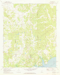 1971 Tyro1973 Print · USGSThe rural borderlands of Lafayette, Tate, and Marshall counties are captured here in the early 1970s before modern development altered these small communities. Researchers can trace family sites at Mt Patient Cem, Langstons Cem, and rural hubs like Harmontown and Tyro.2 unique versions available
 - 1975 Map of Senatobia SW, 1976 Print
 1975 Senatobia SW1976 Print · USGSPanola County agricultural life and small-town footprints are captured in this mid-seventies aerial survey. Genealogists and researchers can trace property lines and land use between the settlements of Senatobia, Como, and New Town.
 - 1975 Map of Sardis NW, 1976 Print
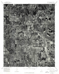
 1975 Sardis NW1976 Print · USGSPanola County in the mid-1970s is revealed in this detailed aerial survey, showing the town and its surrounding agricultural landscape. Researchers can trace the development of Sardis and the surrounding farmsteads across the Mississippi terrain.
 - 1975 Map of Sardis SW, 1976 Print
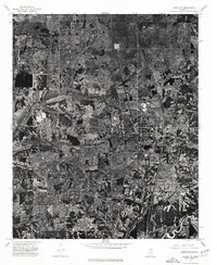
 1975 Sardis SW1976 Print · USGSBatesville and the Panola County countryside are captured from the air in the mid-1970s, showing the town's expansion toward the Little Tallahatchie River. Trace property lines and evolving street grids around Batesville on this detailed orthophoto.
End of results
Showing maps 1-4 of 4
Top cities of Panola County
- Batesville historical maps
- Sardis historical maps
- Como historical maps
- Courtland historical maps
- Pope historical maps
Frequently asked questions
- What are the different types of historical maps available for Panola County?
- What is the oldest map of Panola County?
- Where can I purchase historical maps of Panola County for my home or office?
- Where can I download high-res historical maps of Panola County?
- Are there historical topographic maps available for Panola County?
- Is there historical aerial imagery available for Panola County?
- Where are historical maps of Panola County sourced from?