1960s Maps of Panola County, Mississippi
Explore 4 historic maps of Panola County from the 1960s. These maps offer a rare glimpse into what life looked like during the 1960s — showing old roads, neighborhoods, homes, and landmarks that have changed or disappeared over time.
Whether you're researching your family's past, planning a metal detecting trip, or studying how Panola County's landscape evolved across the 1960s, these high-resolution maps are a powerful tool for exploring the history of this region.
- Focus on a specific era: All maps on this page are from the 1960s, giving you a focused view of this time period.
- See what’s changed: Compare century-old streets, trails, and buildings to today's modern landscape using overlays and satellite layers.
- Research with precision: Use these maps for genealogy, historical research, land use analysis, or educational projects.
- View, download, or print: Maps are fully viewable online in high resolution, and can be downloaded or printed for your own records.
Start exploring Panola County's history through authentic maps from the 1960s. This is your window into the past.
Panola County, MS maps
(4)- 1960 Map of Helena
 1960 Helena1960 Print · USGSThe Arkansas and Mississippi Delta regions meet along the great river bends during a period of significant agricultural and rail expansion. Genealogists and historians can trace the paths of the Missouri Pacific railroad through Clarendon or locate landings along the Mississippi River and White River.
 - 1962 Map of Crowder, 1965 Print
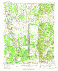 1962 Crowder1965 Print · USGSThe Mississippi Delta meets the eastern hills in the early sixties, showing a landscape shaped by massive water-management projects and deep family roots. Genealogists can locate Shady Grove Cemetery, Walkers Chapel, and the community of Charleston.3 unique versions available
 - 1963 Map of Sledge, 1965 Print
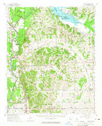
 1963 Sledge1965 Print · USGSNorthwest Mississippi in the early sixties is shown here as a landscape of Delta bayous and rail-side settlements. Genealogists can trace family roots at McDonald Grove Ch, Curtis Station, and the old Chickasaw Boundary Line.2 unique versions available
 - 1963 Map of Crenshaw, 1965 Print
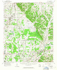
 1963 Crenshaw1965 Print · USGSNorthwest Mississippi in the early sixties reveals a landscape of delta lowlands and upland reservoirs where the Illinois Central rail line connects small rural hubs. Genealogists can locate family landmarks like Brooks Chapel, Kelley's Crossing, and the small community of Strayhorn.
End of results
Showing maps 1-4 of 4
Top cities of Panola County
- Batesville historical maps
- Sardis historical maps
- Como historical maps
- Courtland historical maps
- Pope historical maps
Frequently asked questions
- What are the different types of historical maps available for Panola County?
- What is the oldest map of Panola County?
- Where can I purchase historical maps of Panola County for my home or office?
- Where can I download high-res historical maps of Panola County?
- Are there historical topographic maps available for Panola County?
- Is there historical aerial imagery available for Panola County?
- Where are historical maps of Panola County sourced from?