1920s Maps of Barry County, Missouri
Explore 1 historic maps of Barry County from the 1920s. These maps offer a rare glimpse into what life looked like during the 1920s — showing old roads, neighborhoods, homes, and landmarks that have changed or disappeared over time.
Whether you're researching your family's past, planning a metal detecting trip, or studying how Barry County's landscape evolved across the 1920s, these high-resolution maps are a powerful tool for exploring the history of this region.
- Focus on a specific era: All maps on this page are from the 1920s, giving you a focused view of this time period.
- See what’s changed: Compare century-old streets, trails, and buildings to today's modern landscape using overlays and satellite layers.
- Research with precision: Use these maps for genealogy, historical research, land use analysis, or educational projects.
- View, download, or print: Maps are fully viewable online in high resolution, and can be downloaded or printed for your own records.
Start exploring Barry County's history through authentic maps from the 1920s. This is your window into the past.
Barry County, MO maps
(1)- 1927 Map of Shell Knob
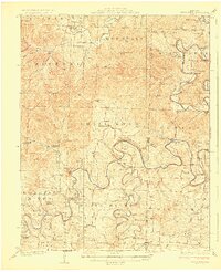 1927 Shell Knob1927 Print · USGSThe river valleys of the Missouri Ozarks are captured here in the mid-twenties, showing the intricate landscape of the White and James Rivers before they were dammed. Researchers can trace family homesteads near numerous country schools like Gaddis School or locate historic river crossings such as Schreiner Ferry and Big Creek Ford.3 unique versions available
End of results
Showing maps 1-1 of 1
Top cities of Barry County
- Cassville historical maps
- Purdy historical maps
- Seligman historical maps
- Exeter historical maps
- Wheaton historical maps
- Washburn historical maps
See more
Frequently asked questions
- What are the different types of historical maps available for Barry County?
- What is the oldest map of Barry County?
- Where can I purchase historical maps of Barry County for my home or office?
- Where can I download high-res historical maps of Barry County?
- Are there historical topographic maps available for Barry County?
- Is there historical aerial imagery available for Barry County?
- Where are historical maps of Barry County sourced from?