1970s Maps of Barry County, Missouri
Explore 21 historic maps of Barry County from the 1970s. These maps offer a rare glimpse into what life looked like during the 1970s — showing old roads, neighborhoods, homes, and landmarks that have changed or disappeared over time.
Whether you're researching your family's past, planning a metal detecting trip, or studying how Barry County's landscape evolved across the 1970s, these high-resolution maps are a powerful tool for exploring the history of this region.
- Focus on a specific era: All maps on this page are from the 1970s, giving you a focused view of this time period.
- See what’s changed: Compare century-old streets, trails, and buildings to today's modern landscape using overlays and satellite layers.
- Research with precision: Use these maps for genealogy, historical research, land use analysis, or educational projects.
- View, download, or print: Maps are fully viewable online in high resolution, and can be downloaded or printed for your own records.
Start exploring Barry County's history through authentic maps from the 1970s. This is your window into the past.
Barry County, MO maps
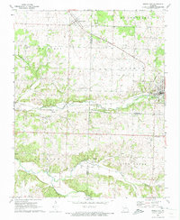
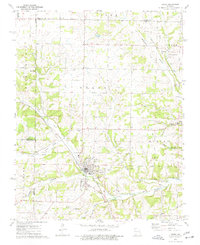
(21)- 1972 Map of Monett, 1973 Print
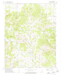
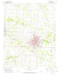 1972 Monett1973 Print · USGSMonett and Pierce City sit at a critical rail junction in the early seventies, marking a landscape defined by small-town industry and traditional community centers. Genealogists can locate family landmarks like Waldensian Church, St Marys Cemetery, and Liberty Church Cemetery.
 - 1972 Map of Verona, 1973 Print
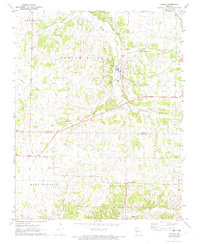 1972 Verona1973 Print · USGSThe Lawrence and Barry County border comes to life in the early seventies as the St Louis - San Francisco rail line cuts through Verona. Genealogists can trace family footprints at New Liberty Ch and Spring River Cem.
 - 1972 Map of McDowell, 1973 Print
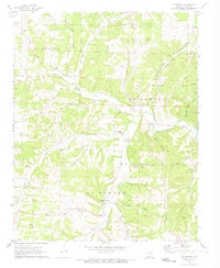 1972 McDowell1973 Print · USGSThe Barry County hill country is shown here in the early seventies, centered on the community of McDowell. Researchers can locate several rural landmarks including Buffington Cem, Victory Ch, and unique geological features like Stansberry Cave.
 - 1972 Map of Purdy, 1973 Print
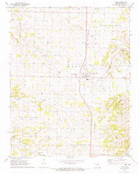 1972 Purdy1973 Print · USGSBarry County was a landscape of rail-connected towns and country parishes in the early seventies, centered on the St Louis - San Francisco line. Genealogists can locate family landmarks like Henderson Cem, Stinett Cem, and the settlement of Corsicana.
 - 1972 Map of Grandview, 1973 Print
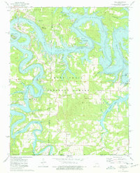
 1972 Grandview1973 Print · USGSThe rural Ozarks near the Missouri border come to life in this early 1970s portrait of Berryville and the Kings River valley. Genealogists and hikers can trace the Old Railroad Grade or locate family sites like Williams Cem and Blackjack Ch.
 - 1972 Map of Pierce City, 1973 Print
 1972 Pierce City1973 Print · USGSThe rail-and-creek landscape of Southwest Missouri comes to life in the early seventies, showing the area as the railroad era matured. Genealogists and historians can trace families near Pierce City, Yonkerville, and the rural Berwick Ch.
 - 1972 Map of Eureka Springs, 1973 Print
 1972 Eureka Springs1973 Print · USGSEureka Springs and the surrounding Ozark hills are captured in the early seventies, a landscape defined by deep river valleys and spiritual landmarks. Genealogists and historians can trace the OLD RAILROAD GRADE past Gaskins Switch or locate the Rock Springs Ch and Eureka Springs Cem.
 - 1972 Map of Wheaton, 1973 Print
 1972 Wheaton1973 Print · USGSThe rural landscapes of Barry and Newton Counties come to life in this early 1970s survey of the Missouri Ozarks. Genealogists and local historians can trace family-named sites like Barker Cem, the community at Fairview, and Mt Olive Ch.
 - 1974 Map of Shell Knob, 1977 Print
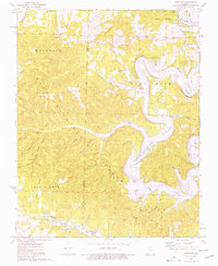
 1974 Shell Knob1977 Print · USGSThe Ozark plateau of southwest Missouri is captured here in the mid-1970s, showcasing a landscape of national forest and scattered mountain settlements. Genealogists can locate several family cemeteries like Doughty Cem and Snyder Cem alongside rural hubs such as Hill City and Lohmer.2 unique versions available
 - 1974 Map of Crane, 1977 Print
 1974 Crane1977 Print · USGSStone County and the settlement of Crane are documented here in the mid-seventies, showing a landscape defined by railroad corridors and spring-fed hollows. Family historians can locate several local burial grounds and churches, including the Masonic Cem, Hood Cem, and Shiloh Ch.
 - 1974 Map of Elsey, 1977 Print
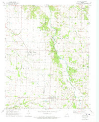
 1974 Elsey1977 Print · USGSStone County’s rugged Ozark terrain and river valleys are captured here in the 1970s as the James River flows toward the reservoir. Genealogists can locate several remote burial sites and congregations, including Carney Cem, Wilson Cem, and Vine Hill Ch.
 - 1974 Map of Exeter, 1977 Print
 1974 Exeter1977 Print · USGSBarry County in the mid-seventies maintains its rural character as the St Louis-San Francisco railroad continues to link the towns of Butterfield and Exeter. Researchers can trace old family sites at Vineyard Cem or follow the path of the Old Railroad Grade through the hills.
 - 1974 Map of Golden, 1977 Print
 1974 Golden1977 Print · USGSThe Missouri-Arkansas border region in the mid-1970s shows the impact of large-scale water management on the Ozark landscape. Researchers can trace the intersections of forest and lake life through landmarks like Golden, Rock Creek Ch, and the Easley Cem.
 - 1974 Map of Viola, 1977 Print
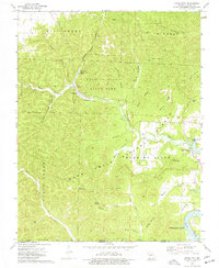
 1974 Viola1977 Print · USGSThe Missouri Ozarks are revealed in the mid-seventies just as the recreation economy took hold along the shores of Table Rock Lake. Genealogists and local historians can trace family markers at Viola Cem or locate the rural Carr Lane Ch and Shell Knob Lookout Tower.
 - 1974 Map of Aurora, 1977 Print
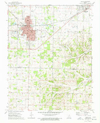 1974 Aurora1977 Print · USGSAurora and the surrounding Ozark foothills are captured here in the mid-1970s, showcasing the region's transition from prairie to plateau. Researchers can trace historic family landmarks such as Buck Prairie Cem, Wise Spring, and the rural community of Revisville.
 - 1974 Map of Eagle Rock, 1977 Print
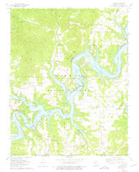
 1974 Eagle Rock1977 Print · USGSThe Missouri Ozarks meet the rising waters of the White River in the mid-1970s, where Barry County’s deep hollows were being shaped by recreation and forestry. Researchers can find family-named landmarks like Munsey Cem and Panther Cave, or trace the Roaring River from its spring to Table Rock Lake.
 - 1974 Map of Seligman, 1977 Print
 1974 Seligman1977 Print · USGSBarry County, Missouri, is captured in the mid-seventies just as the St Louis-San Francisco rail line connected the hill towns of Washburn and Seligman. Researchers can trace rural lineages through sites like the Washburn Prairie Cem, Rock Springs Ch, and McCann Cave.
 - 1974 Map of Cape Fair, 1977 Print
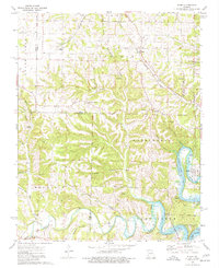
 1974 Cape Fair1977 Print · USGSThe James River and Table Rock Lake define this Stone County landscape in the 1970s, showcasing a mix of deep Ozark hollows and modern lakefront access. Genealogists and hikers can locate Cape Fair Cem, the Woolly Creek Community Hall, and the remote Piney Creek Cave.
 - 1974 Map of Jenkins, 1977 Print
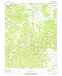
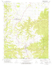
 1974 Jenkins1977 Print · USGSThe Ozark highlands of Barry County appear here in the mid-seventies, centered on the rural crossroads of Jenkins and Scholten. Genealogists and local historians can trace family locations near Mars Hill Ch, the Clio Cem, and the Jenkins Lookout Tower.
 - 1974 Map of Cassville, 1977 Print
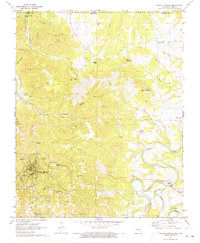
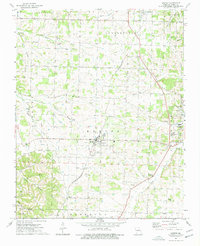
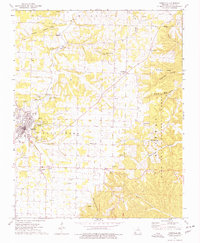 1974 Cassville1977 Print · USGSCassville and the surrounding Barry County landscape are captured here in the mid-seventies, showing the transition from town to the Ozark hollows. Researchers can trace family sites at Oak Hill Cem and Horner Cem or locate regional landmarks like Crystal Caverns.
 - 1979 Map of Fayetteville, 1980 Print
 1979 Fayetteville1980 Print · USGSNorthwest Arkansas and the tristate corner show a booming corridor of rail-linked towns and highland forests in the late seventies. Researchers can trace historic landmarks like Pea Ridge National Military Park, the Frisco RR, and the University of Arkansas.2 unique versions available
End of results
Showing maps 1-21 of 21
Top cities of Barry County
- Cassville historical maps
- Purdy historical maps
- Seligman historical maps
- Exeter historical maps
- Wheaton historical maps
- Washburn historical maps
See more
Frequently asked questions
- What are the different types of historical maps available for Barry County?
- What is the oldest map of Barry County?
- Where can I purchase historical maps of Barry County for my home or office?
- Where can I download high-res historical maps of Barry County?
- Are there historical topographic maps available for Barry County?
- Is there historical aerial imagery available for Barry County?
- Where are historical maps of Barry County sourced from?