1990s Maps of Barry County, Missouri
Explore 7 historic maps of Barry County from the 1990s. These maps offer a rare glimpse into what life looked like during the 1990s — showing old roads, neighborhoods, homes, and landmarks that have changed or disappeared over time.
Whether you're researching your family's past, planning a metal detecting trip, or studying how Barry County's landscape evolved across the 1990s, these high-resolution maps are a powerful tool for exploring the history of this region.
- Focus on a specific era: All maps on this page are from the 1990s, giving you a focused view of this time period.
- See what’s changed: Compare century-old streets, trails, and buildings to today's modern landscape using overlays and satellite layers.
- Research with precision: Use these maps for genealogy, historical research, land use analysis, or educational projects.
- View, download, or print: Maps are fully viewable online in high resolution, and can be downloaded or printed for your own records.
Start exploring Barry County's history through authentic maps from the 1990s. This is your window into the past.
Barry County, MO maps
(7)- 1999 Map of Viola, 2002 Print
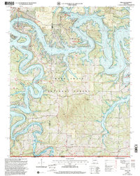 1999 Viola2002 Print · USGSTable Rock Lake dominates this Ozark landscape at the close of the century, where the Missouri and Arkansas border meets. Genealogists and local historians can trace rural roots through landmarks like Carr Lane Ch, Viola Cem, and the settlement of Nauvoo.
 - 1999 Map of Cape Fair, 2002 Print
 1999 Cape Fair2002 Print · USGSThe Ozark hill country of Stone County comes alive in this late twentieth-century survey of the Table Rock Lake shoreline. Researchers can locate the community of Cape Fair, find local landmarks like Virgin Bluff, and trace the rugged Piney Creek Wilderness Boundary.
 - 1999 Map of Golden, 2002 Print
 1999 Golden2002 Print · USGSTable Rock Lake winds through the Ozark hills of Missouri and Arkansas in the late nineties, defining a landscape of deep-water coves and forested ridges. Researchers can locate family burial sites like Painter Cem or trace the rural character of Golden and Mano.
 - 1999 Map of Eagle Rock, 2002 Print
 1999 Eagle Rock2002 Print · USGSBarry County during the late nineties shows a landscape defined by the conservation of the Ozarks and the rising waters of the White River. Researchers can locate the Munsey Cem, trace the waters of Radium Spring, or explore Roaring River State Park.
 - 1999 Map of Seligman, 2002 Print
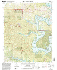
 1999 Seligman2002 Print · USGSBarry County and the Missouri-Arkansas border appear in the late 1990s as a landscape of timbered ridges and family cemeteries. Researchers can trace land ties at Washburn Prairie Cemetery or locate landmarks like McCann Cave and Rock Springs Church.
 - 1999 Map of Cassville, 2002 Print
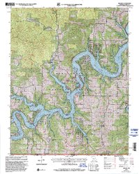
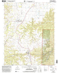
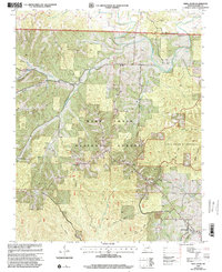
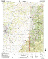 1999 Cassville2002 Print · USGSCassville and the western edge of the Ozarks are captured here at the close of the century, showing a landscape defined by forest hollows and deep springs. Genealogists can locate family sites at Quaker Cem Merles Chapel, Ennis Cem, and Union Chapel or trace the roads through Corder Hollow.
 - 1999 Map of Shell Knob, 2002 Print
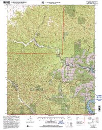
 1999 Shell Knob2002 Print · USGSBarry County in the late 1990s is characterized by the deep hollows of the Ozarks and the established community of Shell Knob. Genealogists and hikers can trace family sites like Pierce Cem, visit Rockhouse Spring, or explore the primitive paths of the Piney Creek Wilderness.
End of results
Showing maps 1-7 of 7
Top cities of Barry County
- Cassville historical maps
- Purdy historical maps
- Seligman historical maps
- Exeter historical maps
- Wheaton historical maps
- Washburn historical maps
See more
Frequently asked questions
- What are the different types of historical maps available for Barry County?
- What is the oldest map of Barry County?
- Where can I purchase historical maps of Barry County for my home or office?
- Where can I download high-res historical maps of Barry County?
- Are there historical topographic maps available for Barry County?
- Is there historical aerial imagery available for Barry County?
- Where are historical maps of Barry County sourced from?