1940s Maps of Barry County, Missouri
Explore 9 historic maps of Barry County from the 1940s. These maps offer a rare glimpse into what life looked like during the 1940s — showing old roads, neighborhoods, homes, and landmarks that have changed or disappeared over time.
Whether you're researching your family's past, planning a metal detecting trip, or studying how Barry County's landscape evolved across the 1940s, these high-resolution maps are a powerful tool for exploring the history of this region.
- Focus on a specific era: All maps on this page are from the 1940s, giving you a focused view of this time period.
- See what’s changed: Compare century-old streets, trails, and buildings to today's modern landscape using overlays and satellite layers.
- Research with precision: Use these maps for genealogy, historical research, land use analysis, or educational projects.
- View, download, or print: Maps are fully viewable online in high resolution, and can be downloaded or printed for your own records.
Start exploring Barry County's history through authentic maps from the 1940s. This is your window into the past.
Barry County, MO maps
(9)- 1941 Map of Rocky Comfort, 1962 Print
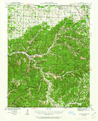 1941 Rocky Comfort1962 Print · USGSThe Missouri Ozarks are captured here in the early 1940s, showing a landscape defined by the winding Big Sugar Creek and the Missouri and Arkansas railroad. Researchers can trace rural life through dozens of local sites like Chitwood Cem, Rocky Comfort, and the Spring Hill Sch.2 unique versions available
 - 1942 Map of Aurora, 1961 Print
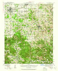 1942 Aurora1961 Print · USGSThe northern Ozarks come to life in this mid-century survey of the rugged borderlands where three counties meet. Researchers can trace the path of the Missouri Pacific railroad through Aurora or locate family roots at rural landmarks like Charity Cem and Mountain Home Sch.2 unique versions available
 - 1943 Map of Ritchey
 1943 Ritchey1943 Print · USGSSouthwest Missouri during the war years shows a landscape of busy railroads and emerging military sites. Genealogists can trace family roots through numerous local landmarks like Odd Fellows Cem, Dungy Mine, and rural centers such as Stark City.2 unique versions available
 - 1943 Map of Monett
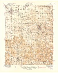
 1943 Monett1943 Print · USGSCrossing the Barry and Lawrence County line during the mid-forties, this map reveals the vital railroad hub at Monett and its surrounding farmsteads. Genealogists can trace family names through landmarks like Red Mill, Arnold Chapel, and the Cox Cem.3 unique versions available
 - 1943 Map of Rocky Comfort
 1943 Rocky Comfort1943 Print · USGSThe Ozark highlands of McDonald County come into sharp focus during the early 1940s, showing a landscape of deep hollows and high ridges. Genealogists can trace family roots through numerous rural landmarks like Seven Star Sch, Greason Cem, and the village of Powell.3 unique versions available
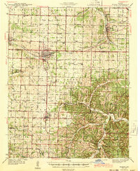
 - 1944 Map of Cassville
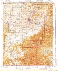 1944 Cassville1944 Print · USGSBarry County and the Missouri Ozarks come alive in the late 1930s, showing the early development of Roaring River State Park. Researchers can trace old family names and sites at True Love Cem, Pender Switch, and the CCC Camp near Cassville.2 unique versions available
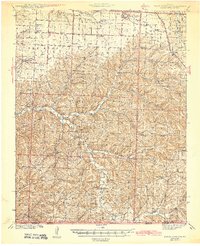
 - 1945 Map of Harrison
 1945 Harrison1945 Print · USGSThe Ozark and Boston Mountains straddle the Missouri-Arkansas border during the mid-forties, showing a landscape of forest ridges and river valleys. Genealogists and historians can trace rail-connected towns like Monett and West Plains or early lake developments at Bull Shoals Res and Norfork Lake.
 - 1945 Map of Aurora
 1945 Aurora1945 Print · USGSThe Ozark plateau around Aurora and Crane is captured here during the mid-forties, showing a landscape defined by rail junctions and rural school districts. Researchers can trace ancestral locations like Stubblefield Cem, the Clay Hill Ch, and old springs including Bean Factory Spr.2 unique versions available
 - 1949 Map of Harrison
 1949 Harrison1949 Print · USGSThe Ozark highlands of northern Arkansas and southern Missouri are shown just after the war, when the White River still followed its original course. Genealogists and historians can trace rail lines like the Missouri & Arkansas RR and locate rural hubs like Harrison, Eureka Springs, and Mountain Home.
End of results
Showing maps 1-9 of 9
Top cities of Barry County
- Cassville historical maps
- Purdy historical maps
- Seligman historical maps
- Exeter historical maps
- Wheaton historical maps
- Washburn historical maps
See more
Frequently asked questions
- What are the different types of historical maps available for Barry County?
- What is the oldest map of Barry County?
- Where can I purchase historical maps of Barry County for my home or office?
- Where can I download high-res historical maps of Barry County?
- Are there historical topographic maps available for Barry County?
- Is there historical aerial imagery available for Barry County?
- Where are historical maps of Barry County sourced from?