1940s Maps of Boone County, Missouri
Explore 10 historic maps of Boone County from the 1940s. These maps offer a rare glimpse into what life looked like during the 1940s — showing old roads, neighborhoods, homes, and landmarks that have changed or disappeared over time.
Whether you're researching your family's past, planning a metal detecting trip, or studying how Boone County's landscape evolved across the 1940s, these high-resolution maps are a powerful tool for exploring the history of this region.
- Focus on a specific era: All maps on this page are from the 1940s, giving you a focused view of this time period.
- See what’s changed: Compare century-old streets, trails, and buildings to today's modern landscape using overlays and satellite layers.
- Research with precision: Use these maps for genealogy, historical research, land use analysis, or educational projects.
- View, download, or print: Maps are fully viewable online in high resolution, and can be downloaded or printed for your own records.
Start exploring Boone County's history through authentic maps from the 1940s. This is your window into the past.
Boone County, MO maps
(10)- 1940 Map of Columbia
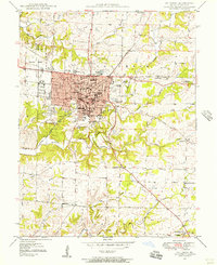
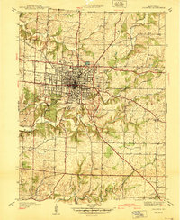 1940 Columbia1940 Print · USGSMid-century Columbia and the University of Missouri are captured here just before the post-war building boom transformed the campus and surrounding Boone County landscape. Researchers can locate vanished landmarks like the original Columbia Airport, the State Serum Plant, and historic rural schoolhouses including Bethel Sch and Keene Sch.
 - 1942 Map of Jefferson City
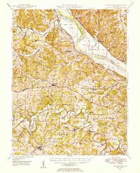
 1942 Jefferson City1942 Print · USGSJefferson City and the surrounding river bluffs are captured in the early years of the war, when rail travel and state agriculture dominated the landscape. Genealogists can locate family-named landmarks and rural schools like Hall Sch, Williams Cem, and the small settlement of New Bloomfield.2 unique versions available
 - 1944 Map of Millersburg, 1963 Print
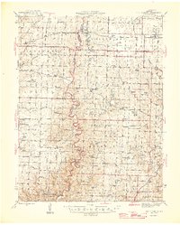
 1944 Millersburg1963 Print · USGSCentral Missouri's rural heartland is documented here in the mid-1940s, showing a landscape shaped by coal mining and country school districts. Trace local history at Stephens and Millersburg, or find family sites like Hundley Cem and Monocle Chapel.
 - 1945 Map of Centralia
 1945 Centralia1945 Print · USGSNorth Central Missouri is shown just after the war, featuring a landscape defined by its rail junctions and numerous rural school districts. Genealogists can trace family heritage through dozens of named sites like Skull Lick Cem, Hallsville, and Angell Sch.2 unique versions available
 - 1946 Map of Millersburg
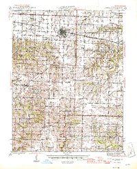
 1946 Millersburg1946 Print · USGSMid-Missouri farming and mining communities come alive in this mid-century survey of the Boone and Callaway county line. Genealogists and historians can locate dozens of rural landmarks, from the Manacle Chapel and Hundley Cem to local schools like Sunrise Sch.2 unique versions available
 - 1947 Map of Jefferson City, 1949 Print
 1947 Jefferson City1949 Print · USGSCentral Missouri and the northern Ozarks come into focus in this late 1940s survey of the river-and-rail landscape. Genealogists and historians can trace the growth of Jefferson City and Sedalia or locate family roots near Bagnell Dam and the Lake of the Ozarks.
 - 1948 Map of Centertown, 1954 Print
 1948 Centertown1954 Print · USGSMid-Missouri farming life in the late forties is captured here, centered on the river bluffs and rail lines between Centertown and Russellville. Researchers can trace rural school districts like Brick School and locate family burial grounds including Enloe Cem and Eberhardt Cem.
 - 1948 Map of Columbia, 1956 Print
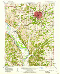
 1948 Columbia1956 Print · USGSColumbia is shown just after the war as a growing university town and regional hub. Local researchers can trace the historic campuses of the University of Missouri and Stephens College, or locate rural landmarks like Sugar Grove Ch and Jewell Cem.2 unique versions available
 - 1948 Map of Columbia, 1960 Print
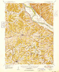
 1948 Columbia1960 Print · USGSMid-century Boone County is captured here just as the educational and agricultural landscape began its post-war transition. Genealogists can trace family landmarks like Sugar Grove Ch and Vaughter Sch or follow the Missouri Pacific along the Missouri River.2 unique versions available
 - 1949 Map of Centertown
 1949 Centertown1949 Print · USGSMid-Missouri river life and rural settlement are captured here just after the war, from the Missouri River bottoms to the uplands. Genealogists can trace family roots through numerous sites like Sweetwater Cem, Bonds Chapel, and the National Cem.
End of results
Showing maps 1-10 of 10
Top cities of Boone County
- Columbia historical maps
- Centralia historical maps
- Ashland historical maps
- Hallsville historical maps
- Sturgeon historical maps
- Rocheport historical maps
See more
Frequently asked questions
- What are the different types of historical maps available for Boone County?
- What is the oldest map of Boone County?
- Where can I purchase historical maps of Boone County for my home or office?
- Where can I download high-res historical maps of Boone County?
- Are there historical topographic maps available for Boone County?
- Is there historical aerial imagery available for Boone County?
- Where are historical maps of Boone County sourced from?