2000-2009 Maps of Boone County, Missouri
Explore 4 historic maps of Boone County from 2000-2009. These maps offer a rare glimpse into what life looked like during the 2000s — showing old roads, neighborhoods, homes, and landmarks that have changed or disappeared over time.
Whether you're researching your family's past, planning a metal detecting trip, or studying how Boone County's landscape evolved across the 2000s, these high-resolution maps are a powerful tool for exploring the history of this region.
- Focus on a specific era: All maps on this page are from the 2000s, giving you a focused view of this time period.
- See what’s changed: Compare century-old streets, trails, and buildings to today's modern landscape using overlays and satellite layers.
- Research with precision: Use these maps for genealogy, historical research, land use analysis, or educational projects.
- View, download, or print: Maps are fully viewable online in high resolution, and can be downloaded or printed for your own records.
Start exploring Boone County's history through authentic maps from the 2000s. This is your window into the past.
Boone County, MO maps
(4)- 2000 Map of Millersburg, 2002 Print
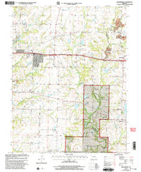 2000 Millersburg2002 Print · USGSBoone and Callaway Counties are captured here at the end of the twentieth century, showing a mix of national forest lands and rural settlements. Genealogists can trace family landmarks like Cedar Ch Cem, Olivet Ch, and the crossroads at Harg.
 - 2000 Map of Hartsburg, 2003 Print
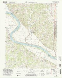 2000 Hartsburg2003 Print · USGSThe Missouri River bluffs and bottomlands are captured here at the end of the twentieth century. Genealogists and historians can trace family sites like Steeley Cem and Bonds Chapel, or locate the Indian Mound and State Auxiliary Prison (Church Farm).
 - 2000 Map of Jefferson City NW, 2003 Print
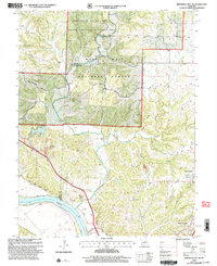 2000 Jefferson City NW2003 Print · USGSCallaway County and the Missouri River bottomlands are captured here at the turn of the millennium as a blend of conservation forest and river-fed agriculture. Researchers can trace family history at Wallace Cemetery or explore the corridor of the Katy Trail State Park near the State Prison Farm.
 - 2000 Map of Millersburg SW, 2003 Print
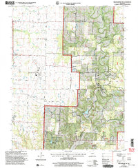 2000 Millersburg SW2003 Print · USGSSouthern Boone County at the turn of the century shows a landscape where university research lands and national forest meet regional infrastructure. Genealogists and local historians can locate Barnes Chapel, Harris Cem, and the rural community of Englewood.
End of results
Showing maps 1-4 of 4
Top cities of Boone County
- Columbia historical maps
- Centralia historical maps
- Ashland historical maps
- Hallsville historical maps
- Sturgeon historical maps
- Rocheport historical maps
See more
Frequently asked questions
- What are the different types of historical maps available for Boone County?
- What is the oldest map of Boone County?
- Where can I purchase historical maps of Boone County for my home or office?
- Where can I download high-res historical maps of Boone County?
- Are there historical topographic maps available for Boone County?
- Is there historical aerial imagery available for Boone County?
- Where are historical maps of Boone County sourced from?