Old Maps of Boone County, Missouri for Hiking & Exploration
Hike through history with 130 historic maps of Boone County. Explore old trails, ghost towns, and forgotten backroads — perfect for outdoor adventurers and local explorers.
- Rediscover forgotten places: Map out old mining camps, roads, and footpaths that no longer exist on modern maps.
- Layer with modern tools: Combine with LiDAR or satellite views to plan hikes through historical terrain.
- Made for exploration: Popular among hikers, overlanders, and local history lovers.
Use these maps to find adventure and explore the hidden past of Boone County.
Boone County, MO maps
(130)- 1886 Map of Jefferson City
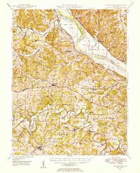
 1886 Jefferson City1886 Print · USGSMid-Missouri was a bustling corridor of river traffic and rail expansion during the 1880s. You can trace the early tracks of the Missouri Pacific Railroad and locate vanished river landings like Nashville or Providence along the winding Missouri River.
 - 1888 Map of Boonville
 1888 Boonville1888 Print · USGSCentral Missouri comes to life in the late nineteenth century as the river economy of Boonville meets the iron rails of the Missouri Pacific Railroad. Genealogists and historians can trace old community centers like Latham Store, Chouteau Springs, and the townships of Richland and Saline.5 unique versions available
 - 1890 Map of Moberly
 1890 Moberly1890 Print · USGSMid-Missouri at the close of the frontier era was a landscape defined by the iron rails of the Wabash and Chicago & Alton lines. Genealogists can trace early homesteads and rail stops from Moberly to Centralia, and find rural communities like Middle Grove or Dripping Spring.6 unique versions available
 - 1890 Map of Glasgow
 1890 Glasgow1890 Print · USGSCentral Missouri in the late nineteenth century was a bustling intersection of river traffic and new rail lines. Genealogists and historians can trace family roots through riverfront towns like Arrow Rock and Glasgow, or locate rural sites like Jackman Mills and Whites Store.5 unique versions available
 - 1894 Map of Jefferson City
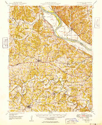
 1894 Jefferson City1894 Print · USGSMid-Missouri during the late nineteenth century was a landscape of river landings and burgeoning rail towns. Genealogists and historians can trace early track layouts of the Missouri Pacific Railroad and locate interior settlements like Ashland, Millersburg, and Centretown.4 unique versions available
 - 1917 Map of Sturgeon
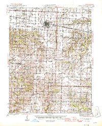
 1917 Sturgeon1917 Print · USGSMid-Missouri rural life is captured here in the years before the First World War, centered on the Sturgeon rail connection. Researchers can trace ancestral farmsteads through dozens of local landmarks like Indian Mound, Stephens, and the many country schoolhouses like Wade School.3 unique versions available
 - 1935 Map of Columbia
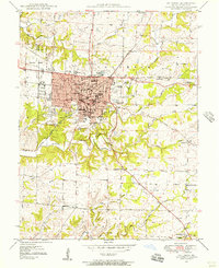
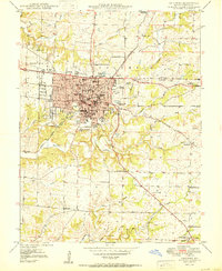
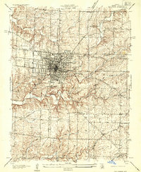 1935 Columbia1935 Print · USGSMid-1930s Columbia is captured here as a burgeoning college town and regional crossroads just before the expansion of the modern highway system. Researchers can trace the early footprints of the University of Missouri, locate the original Columbia Airport, and find rural landmarks like Sugar Grove Sch and Bethel Ch.
 - 1939 Map of Jefferson City, 1954 Print
 1939 Jefferson City1954 Print · USGSMissouri's capital and the surrounding river bluffs are captured here in the late thirties, showing the region's transition between rural farmland and state governance. Researchers can locate family landmarks like Providence Cem, the Algoa Reformatory, and various schools such as Sycamore Sch.2 unique versions available
 - 1940 Map of Columbia
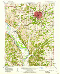
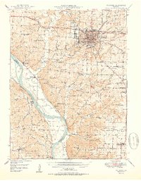
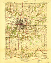 1940 Columbia1940 Print · USGSMid-century Columbia and the University of Missouri are captured here just before the post-war building boom transformed the campus and surrounding Boone County landscape. Researchers can locate vanished landmarks like the original Columbia Airport, the State Serum Plant, and historic rural schoolhouses including Bethel Sch and Keene Sch.
 - 1942 Map of Jefferson City
 1942 Jefferson City1942 Print · USGSJefferson City and the surrounding river bluffs are captured in the early years of the war, when rail travel and state agriculture dominated the landscape. Genealogists can locate family-named landmarks and rural schools like Hall Sch, Williams Cem, and the small settlement of New Bloomfield.2 unique versions available
 - 1944 Map of Millersburg, 1963 Print
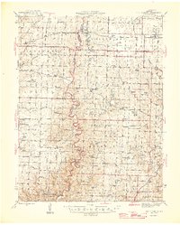
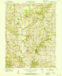
 1944 Millersburg1963 Print · USGSCentral Missouri's rural heartland is documented here in the mid-1940s, showing a landscape shaped by coal mining and country school districts. Trace local history at Stephens and Millersburg, or find family sites like Hundley Cem and Monocle Chapel.
 - 1945 Map of Centralia
 1945 Centralia1945 Print · USGSNorth Central Missouri is shown just after the war, featuring a landscape defined by its rail junctions and numerous rural school districts. Genealogists can trace family heritage through dozens of named sites like Skull Lick Cem, Hallsville, and Angell Sch.2 unique versions available
 - 1946 Map of Millersburg
 1946 Millersburg1946 Print · USGSMid-Missouri farming and mining communities come alive in this mid-century survey of the Boone and Callaway county line. Genealogists and historians can locate dozens of rural landmarks, from the Manacle Chapel and Hundley Cem to local schools like Sunrise Sch.2 unique versions available
 - 1947 Map of Jefferson City, 1949 Print
 1947 Jefferson City1949 Print · USGSCentral Missouri and the northern Ozarks come into focus in this late 1940s survey of the river-and-rail landscape. Genealogists and historians can trace the growth of Jefferson City and Sedalia or locate family roots near Bagnell Dam and the Lake of the Ozarks.
 - 1948 Map of Centertown, 1954 Print
 1948 Centertown1954 Print · USGSMid-Missouri farming life in the late forties is captured here, centered on the river bluffs and rail lines between Centertown and Russellville. Researchers can trace rural school districts like Brick School and locate family burial grounds including Enloe Cem and Eberhardt Cem.
 - 1948 Map of Columbia, 1956 Print
 1948 Columbia1956 Print · USGSColumbia is shown just after the war as a growing university town and regional hub. Local researchers can trace the historic campuses of the University of Missouri and Stephens College, or locate rural landmarks like Sugar Grove Ch and Jewell Cem.2 unique versions available
 - 1948 Map of Columbia, 1960 Print
 1948 Columbia1960 Print · USGSMid-century Boone County is captured here just as the educational and agricultural landscape began its post-war transition. Genealogists can trace family landmarks like Sugar Grove Ch and Vaughter Sch or follow the Missouri Pacific along the Missouri River.2 unique versions available
 - 1949 Map of Centertown
 1949 Centertown1949 Print · USGSMid-Missouri river life and rural settlement are captured here just after the war, from the Missouri River bottoms to the uplands. Genealogists can trace family roots through numerous sites like Sweetwater Cem, Bonds Chapel, and the National Cem.
 - 1950 Map of Columbia
 1950 Columbia1950 Print · USGSMid-century Columbia and its surrounding Boone County landscape are captured here just after the post-war culture revision. Researchers can trace the early footprint of the University of Missouri, locate family sites near Jewell Cem, or find rural landmarks like Sugar Grove Ch.2 unique versions available
 - 1950 Map of Columbia
 1950 Columbia1950 Print · USGSMid-century Columbia and the Missouri River bottoms are captured here during a period of steady institutional and rail-driven growth. Genealogists and researchers can locate numerous country schools and churches like Mt Zion Ch, Huntsdale, and Valley Springs Sch.2 unique versions available
 - 1952 Map of Rocheport, 1953 Print
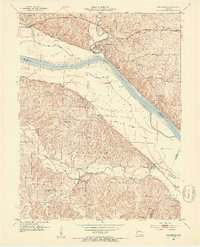 1952 Rocheport1953 Print · USGSThe river bluffs of Boone and Cooper County come alive in the early fifties, showing the vital junctions of the Missouri River and two major rail lines. Researchers can trace the layout of Rocheport, locate family sites like Gooch Mill, or find old rural landmarks like Highland Sch and Copp Chapel.4 unique versions available
 - 1952 Map of Hilldale, 1953 Print
 1952 Hilldale1953 Print · USGSThe rural borderlands of Howard and Boone counties are captured here in the early fifties, showing a landscape defined by winding creeks and a dense network of country schools. Researchers can trace local heritage through sites like Moniteau Chapel, Ricketts Cem, and the Union Sch house.2 unique versions available
 - 1953 Map of Moberly
 1953 Moberly1953 Print · USGSMid-century north-central Missouri is documented here as a bustling intersection of river commerce and heavy rail. Researchers can trace historic family-named landmarks and transport hubs from the Missouri River corridor to the rail yards of Moberly, Chillicothe, and Macon.
 - 1954 Map of Jefferson City
 1954 Jefferson City1954 Print · USGSCentral Missouri in the early postwar years showcases a landscape defined by the winding Lake of the Ozarks and the state capital at Jefferson City. Researchers can trace the mid-century rail networks of the Missouri Pacific RR and locate rural communities like Tuscumbia, St Elizabeth, and St Anthony.2 unique versions available
 - 1954 Map of Moberly, 1969 Print
 1954 Moberly1969 Print · USGSMid-century Missouri is captured here during a period of transition for its river towns and rail hubs. Genealogists and historians can trace the paths of the Wabash railroad through Moberly or explore the riverside layout of Lexington and Brunswick.3 unique versions available
Showing maps 1-25 of 130
Top cities of Boone County
- Columbia historical maps
- Centralia historical maps
- Ashland historical maps
- Hallsville historical maps
- Sturgeon historical maps
- Rocheport historical maps
See more
Frequently asked questions
- What are the different types of historical maps available for Boone County?
- What is the oldest map of Boone County?
- Where can I purchase historical maps of Boone County for my home or office?
- Where can I download high-res historical maps of Boone County?
- Are there historical topographic maps available for Boone County?
- Is there historical aerial imagery available for Boone County?
- Where are historical maps of Boone County sourced from?