1980s Maps of Maries County, Missouri
Explore 15 historic maps of Maries County from the 1980s. These maps offer a rare glimpse into what life looked like during the 1980s — showing old roads, neighborhoods, homes, and landmarks that have changed or disappeared over time.
Whether you're researching your family's past, planning a metal detecting trip, or studying how Maries County's landscape evolved across the 1980s, these high-resolution maps are a powerful tool for exploring the history of this region.
- Focus on a specific era: All maps on this page are from the 1980s, giving you a focused view of this time period.
- See what’s changed: Compare century-old streets, trails, and buildings to today's modern landscape using overlays and satellite layers.
- Research with precision: Use these maps for genealogy, historical research, land use analysis, or educational projects.
- View, download, or print: Maps are fully viewable online in high resolution, and can be downloaded or printed for your own records.
Start exploring Maries County's history through authentic maps from the 1980s. This is your window into the past.
Maries County, MO maps
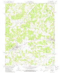
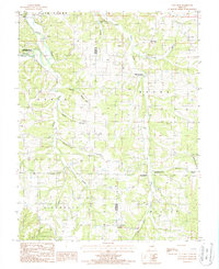
(15)- 1980 Map of Nagogami Lodge, 1981 Print
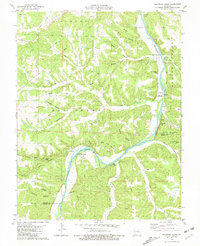 1980 Nagogami Lodge1981 Print · USGSThe Gasconade River flows through Maries and Phelps counties in the early 1980s, revealing a landscape of remote hollows and riverside retreats. Trace family roots at Hughes Chapel and Ramsey Cem, or locate landmarks like Nagogami Lodge and Stickney.
 - 1980 Map of Vichy, 1981 Print
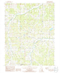
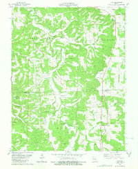 1980 Vichy1981 Print · USGSThe northern Ozarks come into focus in the late seventies as the area around Vichy balances its rural roots with aviation and industry. Genealogists can trace family names across a dozen burial sites like Tennison Cem or locate the Macedonia Ch and local Claypits.
 - 1981 Map of Vienna
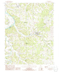
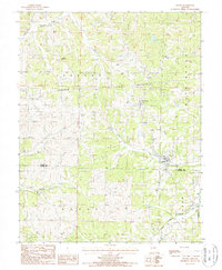
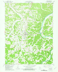 1981 Vienna1981 Print · USGSVienna and the surrounding Maries County countryside are captured here in the early eighties, centered between two major river systems. Genealogists can trace family landmarks like Poor Farm Cem and Visitation Ch or locate the site of Kilns south of town.
 - 1981 Map of Freeburg
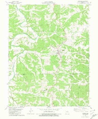 1981 Freeburg1981 Print · USGSFreeburg and the surrounding Ozark foothills are captured here in the early eighties as a network of rural roads and family hollows. Genealogists and local historians can trace landmarks like Holy Family Cem, the Maries River, and old Kilns near the county line.
 - 1981 Map of Belle
 1981 Belle1981 Print · USGSThe tri-county borderlands of Maries, Gasconade, and Osage Counties come alive in this early 1980s survey of the Missouri uplands. Local historians can trace the network of clay mining and rural life through landmarks like Beulah Ch and numerous family plots such as Backues Cem and Heyer Cem.
 - 1981 Map of Summerfield
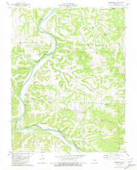 1981 Summerfield1981 Print · USGSThe Gasconade River breaks through Osage and Maries counties in the early 1980s, revealing a landscape of limestone bluffs and rural settlements. Genealogists and historians can trace family locations at Summerfield, the Pilot Knob Ch, and Branson Cemetery.
 - 1981 Map of Paydown
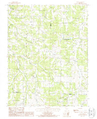
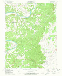 1981 Paydown1981 Print · USGSThe Gasconade River breaks through the Missouri hills in the early 1980s, revealing a landscape of remote settlements and riverside recreation. Genealogists and local historians can trace family roots at Snodgrass Cem, Union Hill Ch Cem, and the high-elevation Vichy Lookout Tower.2 unique versions available
 - 1983 Map of Lake Of The Ozarks, 1984 Print
 1983 Lake Of The Ozarks1984 Print · USGSThe Lake of the Ozarks region in the early eighties shows a landscape of deep river bends and growing recreation. Genealogists can trace family names and small settlements from Versailles to Meta and locate old mining sites like Tiff Mine.
 - 1985 Map of Sullivan
 1985 Sullivan1985 Print · USGSMid-1980s Missouri comes into focus here as the Ozark landscape balances industrial mining with river recreation. Genealogists and historians can trace the St Louis-San Francisco RR through Sullivan and locate landmarks like Pea Ridge Mine or St Cloud Church.3 unique versions available
 - 1987 Map of Big Bend
 1987 Big Bend1987 Print · USGSThe Maries River valley comes into sharp focus during the late 1980s, showing a landscape shaped by both nature and modern infrastructure. Researchers can trace the rural layout of Big Bend, locate the settlement of Shantytown, and find family sites near Clifty Hollow.
 - 1987 Map of Van Cleve
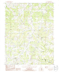
 1987 Van Cleve1987 Print · USGSMaries and Miller counties are seen here in the late eighties, a landscape defined by the winding course of Tavern Creek. Researchers can trace old family locations and local settlements like Van Cleve, Meyerstown, and the Boeckman Bridge State Wildlife Area.
 - 1987 Map of Brinktown, 1988 Print
 1987 Brinktown1988 Print · USGSMaries County near the close of the twentieth century was a landscape of winding river valleys and quiet rural outposts. Local historians can trace family locations near Brinktown and Venus, or locate sites like the Cem and the Gravel Pit along the Maries River.
 - 1987 Map of Brays, 1988 Print
 1987 Brays1988 Print · USGSThe rural borderlands of Miller, Maries, and Pulaski counties are captured in the late 1980s as a landscape of winding creeks and wooded ridges. Researchers can trace family roots at several small Cem sites or follow the paths of Little Tavern Creek and the Maries River.
 - 1987 Map of Meta, 1988 Print
 1987 Meta1988 Print · USGSOsage and Cole counties in the mid-1980s reveal a landscape of river-bottom commerce and hilltop communication towers. Researchers can trace the winding Osage River past St Thomas or locate industrial sites like the Kilns and Meta Tower Site.
 - 1987 Map of Argyle, 1988 Print
 1987 Argyle1988 Print · USGSThe borderlands of Osage and Maries counties are captured here in the late twentieth century, showing a landscape of winding creeks and small crossroads. Genealogists can trace family footprints near Argyle, Koeltztown, and the Cem along the banks of Loose Creek.
End of results
Showing maps 1-15 of 15
Top cities of Maries County
Frequently asked questions
- What are the different types of historical maps available for Maries County?
- What is the oldest map of Maries County?
- Where can I purchase historical maps of Maries County for my home or office?
- Where can I download high-res historical maps of Maries County?
- Are there historical topographic maps available for Maries County?
- Is there historical aerial imagery available for Maries County?
- Where are historical maps of Maries County sourced from?