Old Maps of Ozark County, Missouri for Hiking & Exploration
Hike through history with 199 historic maps of Ozark County. Explore old trails, ghost towns, and forgotten backroads — perfect for outdoor adventurers and local explorers.
- Rediscover forgotten places: Map out old mining camps, roads, and footpaths that no longer exist on modern maps.
- Layer with modern tools: Combine with LiDAR or satellite views to plan hikes through historical terrain.
- Made for exploration: Popular among hikers, overlanders, and local history lovers.
Use these maps to find adventure and explore the hidden past of Ozark County.
Ozark County, MO maps
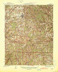
(199)- 1890 Map of Mountain Home, 1954 Print
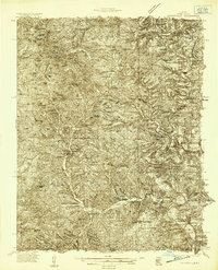
 1890 Mountain Home1954 Print · USGSThe Ozark plateau in the late nineteenth century remains a rugged landscape of winding river valleys and isolated hilltop settlements. Genealogists can trace family footprints across Mountain Home, Buffalo City, and Calico Rock before modern dams reshaped the White River.
 - 1891 Map of Mountain Home
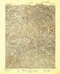
 1891 Mountain Home1891 Print · USGSThe Ozark wilderness around Mountain Home is shown here in the late nineteenth century, dominated by a wild river system. Researchers can trace the network of old river crossings like Traceys F'y and Nelsons F'y alongside early towns such as Buffalo City.
 - 1893 Map of Yellville
 1893 Yellville1893 Print · USGSNorthern Arkansas in the late nineteenth century was a world defined by its rivers and local crossings. You can trace the ancestral ferry routes along the White River and locate settlements with unique local nicknames like Peel (Needmore) and St Joe (Monkey Run).2 unique versions available
 - 1894 Map of Mountain Home
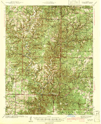
 1894 Mountain Home1894 Print · USGSNorthern Arkansas in the 1890s was a rugged territory defined by the winding White and Buffalo rivers. Genealogists and local historians can trace early river crossings and settlements like Traceys Fy & Fd, Ships Fy, Buffalo City, and Henderson.6 unique versions available
 - 1903 Map of Yellville
 1903 Yellville1903 Print · USGSNorth Central Arkansas in the late nineteenth century is a land of winding river valleys and ridge-top settlements. Genealogists can trace early homesteads and river crossings like Denton Ferry, Yellville, and the remote outposts of Dodd City or St. Joe.
 - 1905 Map of Yellville
 1905 Yellville1905 Print · USGSThe Ozark Mountains and the winding White River define this area at the start of the twentieth century. Genealogists can trace family names through dozens of river crossings and small settlements like Denton Ferry, Rush, and Elixir Springs.3 unique versions available
 - 1929 Map of Yellville, 1954 Print
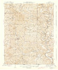
 1929 Yellville1954 Print · USGSThe Ozark river valleys and early rail corridors of north-central Arkansas are shown here during the late 1920s. Researchers can trace historic river crossings like Whites Ferry and Moony Ford or locate regional hubs such as Yellville and Cotter.
 - 1934 Map of Gainesville
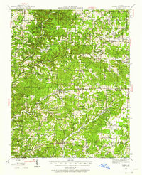
 1934 Gainesville1934 Print · USGSOzark County in the mid-1930s is a landscape of river-dependent settlements and ridges. Genealogists can trace family roots through sites like Price Cem, Smith Chapel, and numerous river crossings including White Ferry and Osburn Ford.2 unique versions available
 - 1936 Map of Thornfield
 1936 Thornfield1936 Print · USGSOzark County in the mid-1930s is a landscape of high ridges and deep river hollows where rural life centered on local schoolhouses and isolated post offices. Researchers can trace family history through sites like Franklin Grove Cem, Thornfield, and Igo School.
 - 1936 Map of Ava
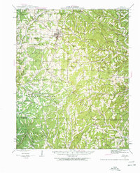
 1936 Ava1936 Print · USGSIn the mid-1930s, this area of the Ozarks was a tapestry of small school districts and rural congregations. Genealogists can trace family footprints across Old Toledo, find remote burial sites like Mt Lebanon Cem, or locate landmarks such as Happy Home Ch.
 - 1937 Map of Buckhart
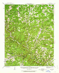
 1937 Buckhart1937 Print · USGSThe Ozark ridges of Douglas and Ozark counties are shown here in the late 1930s, featuring a landscape of isolated farmsteads and rural schoolhouses. Researchers can locate family roots at Rockbridge, trace the waters of Bryant Creek, or find ancestral burial sites like Yates Cem.
 - 1937 Map of Bradleyville
 1937 Bradleyville1937 Print · USGSDouglas County in the late 1930s was a landscape of remote hollows and high ridges connected by a network of one-room schools and small post offices. Trace family roots at Huffman Cem or locate forgotten community hubs like Old Merritt and Lone Star Sch.
 - 1939 Map of Topaz
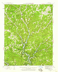
 1939 Topaz1939 Print · USGSThe North Fork River valley in Douglas and Ozark counties is captured here in the late 1930s, showing a landscape defined by riverside mills and rural schools. Genealogists can trace family landmarks across Richville, Siloam Springs, and Hammonds Mill, or find remote sites like Mitts Cem and Little Zion Sch.3 unique versions available
 - 1940 Map of Gainesville
 1940 Gainesville1940 Print · USGSOzark County at the end of the 1930s reveals a landscape of isolated river fords and high-ridge settlements. Genealogists and historians can trace family locations near landmarks like Gainesville, Price Cem, and White Ferry.2 unique versions available
 - 1941 Map of Topaz
 1941 Topaz1941 Print · USGSThe Ozark plateau of the late thirties and early forties comes alive here, showing the river-bound communities of Douglas and Howell Counties. Researchers can locate vanished rural landmarks like Omba Store, Hammonds Mill, and numerous country schools such as New Jail Sch.
 - 1942 Map of Ava, 1960 Print
 1942 Ava1960 Print · USGSThe Missouri Ozarks are captured here during the early 1940s, showing a landscape defined by isolated farmsteads and rural school districts. Genealogists can locate family landmarks like Whites Creek Cem, Nubbin Ridge Sch, and the community of Toledo.2 unique versions available
 - 1943 Map of Protem
 1943 Protem1943 Print · USGSThe Ozark backcountry of Taney and Ozark Counties is shown here in the 1940s, before modern developments changed the landscape. Researchers can find numerous rural schoolhouses like Liberty Sch and family landmarks such as Merritt Cem and Dean Ranch.
 - 1943 Map of Thornfield, 1959 Print
 1943 Thornfield1959 Print · USGSOzark County and the Arkansas border are captured here in the 1940s, highlighting a landscape of river-valley settlements and rural hollows. Genealogists can trace family sites at Franklin Grove Cem, Turnbo Cem, and numerous country schools like Northview Sch.
 - 1943 Map of Buckhart, 1963 Print
 1943 Buckhart1963 Print · USGSThe Ozark plateau of Douglas and Ozark Counties is shown here in the 1940s, a landscape of isolated ridges and creek-side settlements. Researchers can trace family history through dozens of rural landmarks like John Smith Sch, Vera Cruz, and the Tedrick Cem.2 unique versions available
 - 1943 Map of Bradleyville, 1968 Print
 1943 Bradleyville1968 Print · USGSThe Missouri Ozarks during the 1940s are documented here, showing the rural communities of Taney and Douglas counties. Genealogists can trace family homesteads near Bradleyville or locate remote landmarks like Huffman Cem and Whiteside Sch.2 unique versions available
 - 1944 Map of Cureall, 1962 Print
 1944 Cureall1962 Print · USGSThe Missouri-Arkansas borderlands come alive in this mid-century survey of the Ozarks during a time when rural life centered on local river crossings and country schoolhouses. Trace family history through the numerous sites like Alice Mine, Breakup Mill, and Cureall Cem.2 unique versions available
 - 1945 Map of Ava
 1945 Ava1945 Print · USGSThe Missouri Ozarks are documented here in the mid-1940s, revealing a landscape defined by small ridge-top settlements and valley schoolhouses. Genealogists can trace family roots through sites like Liberty Cemetery, Almartha, and the Crossroads School.2 unique versions available
 - 1945 Map of Harrison
 1945 Harrison1945 Print · USGSThe Ozark and Boston Mountains straddle the Missouri-Arkansas border during the mid-forties, showing a landscape of forest ridges and river valleys. Genealogists and historians can trace rail-connected towns like Monett and West Plains or early lake developments at Bull Shoals Res and Norfork Lake.
 - 1945 Map of Thornfield
 1945 Thornfield1945 Print · USGSOzark County in the mid-1940s is captured here through its river-valley settlements and isolated upland schools. Genealogists and historians can trace family locations through named river crossings like Neasby Ford and local landmarks like Franklin Grove Ch or the settlement of Romance.2 unique versions available
 - 1945 Map of Bradleyville
 1945 Bradleyville1945 Print · USGSThe Missouri Ozarks are revealed in the mid-1940s, showing a landscape of small settlements and township life. Trace family roots through many rural schoolhouses like High Lonesome Sch and remote cemeteries like Old Merritt Cem.
Showing maps 1-25 of 199
Top cities of Ozark County
Frequently asked questions
- What are the different types of historical maps available for Ozark County?
- What is the oldest map of Ozark County?
- Where can I purchase historical maps of Ozark County for my home or office?
- Where can I download high-res historical maps of Ozark County?
- Are there historical topographic maps available for Ozark County?
- Is there historical aerial imagery available for Ozark County?
- Where are historical maps of Ozark County sourced from?