1960s Maps of Ozark County, Missouri
Explore 19 historic maps of Ozark County from the 1960s. These maps offer a rare glimpse into what life looked like during the 1960s — showing old roads, neighborhoods, homes, and landmarks that have changed or disappeared over time.
Whether you're researching your family's past, planning a metal detecting trip, or studying how Ozark County's landscape evolved across the 1960s, these high-resolution maps are a powerful tool for exploring the history of this region.
- Focus on a specific era: All maps on this page are from the 1960s, giving you a focused view of this time period.
- See what’s changed: Compare century-old streets, trails, and buildings to today's modern landscape using overlays and satellite layers.
- Research with precision: Use these maps for genealogy, historical research, land use analysis, or educational projects.
- View, download, or print: Maps are fully viewable online in high resolution, and can be downloaded or printed for your own records.
Start exploring Ozark County's history through authentic maps from the 1960s. This is your window into the past.
Ozark County, MO maps
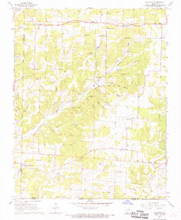
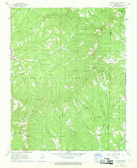
(19)- 1964 Map of Harrison
 1964 Harrison1964 Print · USGSThe Ozark and Boston Mountains of Arkansas and Missouri are captured here in the mid-sixties, showing the rugged highlands before extensive modern development. Genealogists and historians can trace family-named peaks like Gaither Mountain and follow the St Louis-San Francisco RR through Monett and Purdy.
 - 1965 Map of Clarkridge, 1967 Print
 1965 Clarkridge1967 Print · USGSThe northern Arkansas borderlands meet the winding shoreline of Norfork Lake in this mid-1960s survey. Researchers can trace family sites at Quality Ridge Cem, Maynard Cem, and the community of Clarkridge.4 unique versions available
 - 1965 Map of Gamaliel, 1967 Print
 1965 Gamaliel1967 Print · USGSThe northern reaches of the Ozarks meet the waters of the White River basin in the mid-1960s. Researchers can trace the shoreline to Gamaliel Landing, locate family sites at Fluty Cem, and find the rural community of Henderson at the edge of Norfork Lake.2 unique versions available
 - 1966 Map of Gepp, 1967 Print
 1966 Gepp1967 Print · USGSThe Missouri-Arkansas borderlands come alive in the mid-sixties, showing a rural landscape of scattered farmsteads and creek-side settlements. Researchers can trace family roots at Gobbler Trot Cem, visit the Enterprise Ch, or explore the crossroads at Vidette.
 - 1966 Map of Midway, 1967 Print
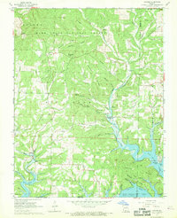
 1966 Midway1967 Print · USGSBaxter County at the height of the reservoir era shows the dramatic impact of the White River dams on the Ozark landscape. Researchers can trace family roots through sites like Three Brothers Cemetery, Liberty Church, and the high-water lines of Bull Shoals Lake.3 unique versions available
 - 1968 Map of Caulfield
 1968 Caulfield1968 Print · USGSThe Missouri-Arkansas borderlands come alive in the late sixties, showing a landscape of deep hollows and rural outposts. Genealogists and historians can locate family landmarks like Joyes Cem, the Alice Mine, and country churches including Shady Grove Ch.
 - 1968 Map of Protem, 1969 Print
 1968 Protem1969 Print · USGSThe northern Taney County hills meet the rising waters of the White River in the late sixties. Genealogists can locate family burial sites at Rueter Cemetery and Merritt Cemetery or trace landmarks like Blackjack Knob and the Mark Twain School.2 unique versions available
 - 1968 Map of Sycamore, 1969 Print
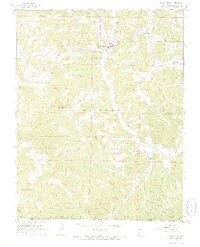
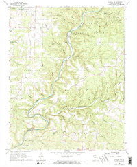
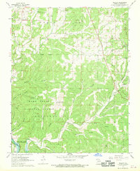
 1968 Sycamore1969 Print · USGSOzark County in the late sixties reveals a landscape of deep creek meanders and traditional Ozark industry. Trace the historic Hodgson Mill and rural community hubs like Zanoni, Smith Chapel, and Sanders Cem.
 - 1968 Map of Pottersville, 1969 Print
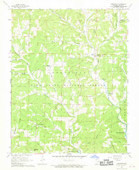
 1968 Pottersville1969 Print · USGSAcross the Howell County hills in the late 1960s, this survey captures a network of rural Ozark communities and isolated farmsteads. Genealogists and historians can trace family roots at Pottersville Cem, Union Grove Ch, and the settlement of Cureall.
 - 1968 Map of Protem NE, 1969 Print
 1968 Protem NE1969 Print · USGSThe wooded border of Taney and Ozark Counties comes into sharp focus during the late 1960s, showing the intersection of forest management and rural life. Researchers can locate remote landmarks like the Caney Lookout Tower, the Hercules settlement, and springs such as Rock Spring.2 unique versions available
 - 1968 Map of Gainesville, 1969 Print
 1968 Gainesville1969 Print · USGSGainesville and the surrounding Ozark County hill country are captured here in the late sixties, just as the region straddles the Missouri-Arkansas border. Researchers can locate family landmarks like Sims Cem, the lookout at Timbered Knob, and the Charcoal Ovens near Lilly Ridge.3 unique versions available
 - 1968 Map of Udall, 1969 Print
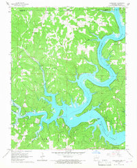
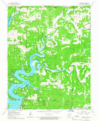
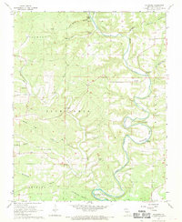
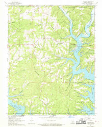
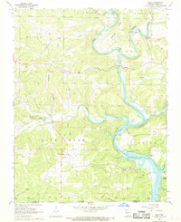 1968 Udall1969 Print · USGSOzark County at the Missouri-Arkansas border is seen here in the late sixties, just as the North Fork River fills into Norfork Lake. Local historians can locate the historic Dawt Mill, family burial grounds at Sallee Cem, and the rural community of Howards Ridge.2 unique versions available
 - 1968 Map of Bakersfield, 1969 Print
 1968 Bakersfield1969 Print · USGSBakersfield and the Ozark county line are captured here in the late sixties, showing a landscape of deep timbered hollows and small border settlements. Researchers can locate country burial sites like Fore Cem and Hawkins Ridge Cem or trace the drainage of Bennetts Bayou near the state line.2 unique versions available
 - 1968 Map of Cureall NW, 1969 Print
 1968 Cureall NW1969 Print · USGSThe Missouri Ozarks are captured here in the late sixties, showcasing the winding North Fork River as it cuts through the Mark Twain National Forest. Researchers can locate rural landmarks like New Liberty Ch, Duncan Ford, and several family cemeteries including Oak Mound Cem and Frazier Cem.2 unique versions available
 - 1968 Map of Theodosia, 1970 Print
 1968 Theodosia1970 Print · USGSThe Ozark hills and the rising waters of the White River watershed are captured here just as the modern reservoir landscape was maturing. Researchers can trace rural lineages through sites like Dugginsville, True Hope Ch, and family landmarks such as Lutie Cem.2 unique versions available
 - 1968 Map of Isabella, 1970 Print
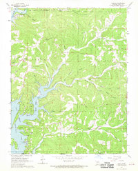 1968 Isabella1970 Print · USGSThe Ozark shorelines of Bull Shoals Lake are captured here in the late sixties as the area transitioned into a regional recreation center. Genealogists and local historians can locate remote landmarks like Pontiac Ch, Upton Cem, and the high peak of Wilkinson Knob.2 unique versions available
 - 1968 Map of Thornfield, 1970 Print
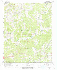
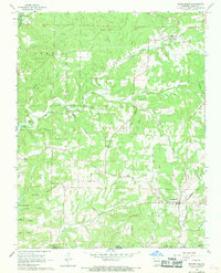
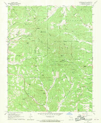
 1968 Thornfield1970 Print · USGSOzark County in the late sixties shows a landscape of deep hollows and high ridges as the reservoir waters reached their southern limits. Genealogists and researchers can trace family sites at Welsh Cem, the Mt Lebanon Ch, and the community of Thornfield.
 - 1968 Map of Willhoit, 1970 Print
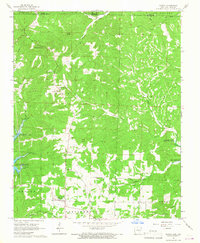
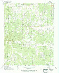
 1968 Willhoit1970 Print · USGSOzark County in the late sixties shows a landscape of timbered ridges and family-named hollows within the national forest. Researchers can locate many local burial sites and landmarks including Peters Cem, the Nottinghill Lookout Tower, and Romance.
 - 1968 Map of Gainesville NW, 1970 Print
 1968 Gainesville NW1970 Print · USGSThe Ozark highlands are captured here in the late sixties, centered on the protected wilderness of the Caney Mountain State Game Refuge. Genealogists and historians can trace family-named sites such as Sheppard Cem, the Romance Lookout Tower, and Brushy Knob Ch.
End of results
Showing maps 1-19 of 19
Top cities of Ozark County
Frequently asked questions
- What are the different types of historical maps available for Ozark County?
- What is the oldest map of Ozark County?
- Where can I purchase historical maps of Ozark County for my home or office?
- Where can I download high-res historical maps of Ozark County?
- Are there historical topographic maps available for Ozark County?
- Is there historical aerial imagery available for Ozark County?
- Where are historical maps of Ozark County sourced from?