1940s Maps of Pettis County, Missouri
Explore 9 historic maps of Pettis County from the 1940s. These maps offer a rare glimpse into what life looked like during the 1940s — showing old roads, neighborhoods, homes, and landmarks that have changed or disappeared over time.
Whether you're researching your family's past, planning a metal detecting trip, or studying how Pettis County's landscape evolved across the 1940s, these high-resolution maps are a powerful tool for exploring the history of this region.
- Focus on a specific era: All maps on this page are from the 1940s, giving you a focused view of this time period.
- See what’s changed: Compare century-old streets, trails, and buildings to today's modern landscape using overlays and satellite layers.
- Research with precision: Use these maps for genealogy, historical research, land use analysis, or educational projects.
- View, download, or print: Maps are fully viewable online in high resolution, and can be downloaded or printed for your own records.
Start exploring Pettis County's history through authentic maps from the 1940s. This is your window into the past.
Pettis County, MO maps
(9)- 1940 Map of Sweet Springs
 1940 Sweet Springs1940 Print · USGSWestern Missouri in the late thirties is revealed here as a landscape of interconnected river valleys and tightly knit rural communities. Genealogists and historians can trace family roots through numerous country schools and landmarks like High Hill Cem, Bleak Mound, and the Missouri Pacific rail line.
 - 1941 Map of Sweet Springs
 1941 Sweet Springs1941 Print · USGSCentral Missouri farmland at the end of the Depression is defined here by the winding Blackwater River and the critical Missouri Pacific rail line. Genealogists and local historians can locate dozens of country schools and churches, such as Holy Cross Sch, Dunksburg, and the High Hill Cem.2 unique versions available
 - 1944 Map of Sedalia West, 1963 Print
 1944 Sedalia West1963 Print · USGSCentral Missouri at the end of the Second World War shows a rural landscape surrounding the growing city of Sedalia. Genealogists and historians can trace family locations through numerous rural landmarks like Quisenberry Sch, Memorial Park Cem, and the State Fair Grounds.
 - 1944 Map of Sedalia East, 1966 Print
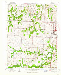
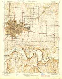
 1944 Sedalia East1966 Print · USGSAs Sedalia expanded during the mid-forties, it remained a vital railroad hub anchored by the Missouri Pacific Shops. Genealogists can trace family roots through numerous neighborhood schools like Whittier Sch or rural landmarks like Hebrew Cem and Backbone Ford.
 - 1945 Map of Sweet Springs
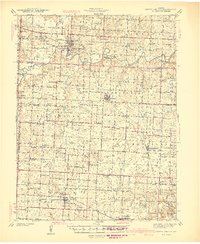
 1945 Sweet Springs1945 Print · USGSCentral Missouri farmland at the end of the 1930s is revealed here, spanning the intersection of four counties. Genealogists can trace family roots through numerous rural landmarks like Holy Cross Ch, Weber Sch, and the isolated High Hill Cem.2 unique versions available
 - 1946 Map of Sedalia West
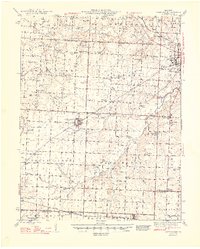
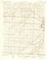 1946 Sedalia West1946 Print · USGSWestern Pettis County comes alive in this post-war survey, showing the agricultural prairie and rural school districts surrounding the county seat. Genealogists can locate family landmarks like Quisenberry Cem, Mc Kee Chapel, and the State Fair Grounds.2 unique versions available
 - 1946 Map of Sedalia East
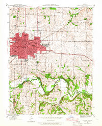
 1946 Sedalia East1946 Print · USGSMid-century Pettis County centers on the bustling railroad city of Sedalia and its surrounding rural townships. Genealogists and historians can trace the foundations of local life through the Missouri Pacific Shops, Hebrew Cem, and country schools like Striped College Sch.2 unique versions available
 - 1947 Map of Jefferson City, 1949 Print
 1947 Jefferson City1949 Print · USGSCentral Missouri and the northern Ozarks come into focus in this late 1940s survey of the river-and-rail landscape. Genealogists and historians can trace the growth of Jefferson City and Sedalia or locate family roots near Bagnell Dam and the Lake of the Ozarks.
 - 1948 Map of Green Ridge
 1948 Green Ridge1948 Print · USGSMid-Missouri farming and rail life are preserved here in the late 1940s, centered on the junction of three major railroads. Genealogists can locate dozens of rural landmarks, from the Quisenberry Cem to the one-room Prairie Flower Sch and McKee Chapel.2 unique versions available
End of results
Showing maps 1-9 of 9
Top cities of Pettis County
- Sedalia historical maps
- La Monte historical maps
- Smithton historical maps
- Green Ridge historical maps
- Houstonia historical maps
- Hughesville historical maps
Frequently asked questions
- What are the different types of historical maps available for Pettis County?
- What is the oldest map of Pettis County?
- Where can I purchase historical maps of Pettis County for my home or office?
- Where can I download high-res historical maps of Pettis County?
- Are there historical topographic maps available for Pettis County?
- Is there historical aerial imagery available for Pettis County?
- Where are historical maps of Pettis County sourced from?