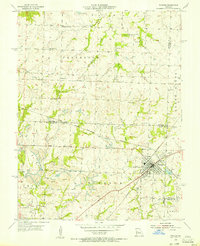
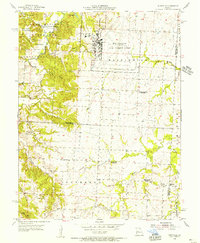
1950s Maps of Pettis County, Missouri
Explore 10 historic maps of Pettis County from the 1950s. These maps offer a rare glimpse into what life looked like during the 1950s — showing old roads, neighborhoods, homes, and landmarks that have changed or disappeared over time.
Whether you're researching your family's past, planning a metal detecting trip, or studying how Pettis County's landscape evolved across the 1950s, these high-resolution maps are a powerful tool for exploring the history of this region.
- Focus on a specific era: All maps on this page are from the 1950s, giving you a focused view of this time period.
- See what’s changed: Compare century-old streets, trails, and buildings to today's modern landscape using overlays and satellite layers.
- Research with precision: Use these maps for genealogy, historical research, land use analysis, or educational projects.
- View, download, or print: Maps are fully viewable online in high resolution, and can be downloaded or printed for your own records.
Start exploring Pettis County's history through authentic maps from the 1950s. This is your window into the past.
Pettis County, MO maps
(10)- 1953 Map of Nelson, 1955 Print
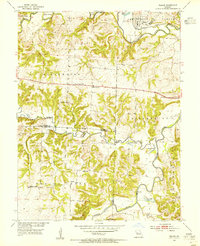 1953 Nelson1955 Print · USGSMid-Missouri farming and river life are preserved here during the early fifties, where the Blackwater River and Lamine River meet. Researchers can locate vanished rural landmarks like Postal Sch, Millers Chapel, and the Raines Cemetery.2 unique versions available
 - 1953 Map of Longwood, 1955 Print
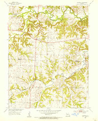 1953 Longwood1955 Print · USGSThe borderlands of Saline and Pettis Counties come alive in the early 1950s, showing a landscape defined by the Blackwater River and rural township life. Genealogists and historians can locate family landmarks like Witcher Cem or trace the old roads near Marshall Junction and Longwood.2 unique versions available
 - 1953 Map of Clifton City, 1955 Print
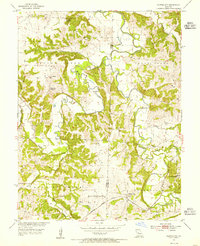 1953 Clifton City1955 Print · USGSThe Pettis and Cooper county line comes alive in the early fifties, centered on the railroad hub of Clifton City. Genealogists can trace family roots at St Josephs Cem, Lee Cem, and the sites of local schools like Scott Sch.2 unique versions available
 - 1953 Map of Beaman, 1955 Print
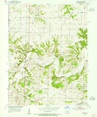 1953 Beaman1955 Print · USGSPettis County rural life is frozen in time during the early fifties, showing a landscape of small schools and creek-side settlements. You can trace family roots at High Hill Cem or locate the Woodland Sch (Abandoned) and the Missouri Kansas Texas line.2 unique versions available
 - 1954 Map of Jefferson City
 1954 Jefferson City1954 Print · USGSCentral Missouri in the early postwar years showcases a landscape defined by the winding Lake of the Ozarks and the state capital at Jefferson City. Researchers can trace the mid-century rail networks of the Missouri Pacific RR and locate rural communities like Tuscumbia, St Elizabeth, and St Anthony.2 unique versions available
 - 1955 Map of Windsor, 1956 Print
 1955 Windsor1956 Print · USGSThe rail junctions and coal mines of Henry County are captured here in the mid-1950s as industry shaped the West Central Missouri landscape. Genealogists and local historians can trace the foundations of Windsor through landmarks like Laurel Oak Cem, the Windsor Fairgrounds, and the rural Sunny Side Sch.2 unique versions available
 - 1955 Map of Burtville, 1956 Print
 1955 Burtville1956 Print · USGSMid-century Johnson County is captured here during the expansion of Whiteman Air Force Base alongside the developing Knob Noster State Park. Genealogists can locate legacy sites like Ellis Cem, the settlement of Burtville, and several rural schoolhouses.2 unique versions available
 - 1955 Map of Jefferson City, 1967 Print
 1955 Jefferson City1967 Print · USGSCentral Missouri in the mid-fifties is defined by the winding Missouri River and the expanding reach of Lake of the Ozarks. Researchers can trace the rail corridors of the Missouri Pacific or locate the early footprint of Whiteman AFB and Jefferson City.4 unique versions available
 - 1958 Map of Jefferson City
 1958 Jefferson City1958 Print · USGSCentral Missouri in the late fifties shows a region transforming through the growth of Whiteman Air Force Base and the Lake of the Ozarks. Researchers can trace rail lines like the Missouri Pacific or find family roots at Enloe Cemetery and Mount Pleasant Cem.
 - 1959 Map of Jefferson City
 1959 Jefferson City1959 Print · USGSCentral Missouri is captured during the mid-fifties as the river economy and rail networks like the Missouri Pacific met the rise of the automobile. Local researchers can trace family landmarks and rural infrastructure from the Lake of the Ozarks up to Providence Cemetery and Knob Noster State Park.
End of results
Showing maps 1-10 of 10
Top cities of Pettis County
- Sedalia historical maps
- La Monte historical maps
- Smithton historical maps
- Green Ridge historical maps
- Houstonia historical maps
- Hughesville historical maps
Frequently asked questions
- What are the different types of historical maps available for Pettis County?
- What is the oldest map of Pettis County?
- Where can I purchase historical maps of Pettis County for my home or office?
- Where can I download high-res historical maps of Pettis County?
- Are there historical topographic maps available for Pettis County?
- Is there historical aerial imagery available for Pettis County?
- Where are historical maps of Pettis County sourced from?