1980s Maps of Pettis County, Missouri
Explore 3 historic maps of Pettis County from the 1980s. These maps offer a rare glimpse into what life looked like during the 1980s — showing old roads, neighborhoods, homes, and landmarks that have changed or disappeared over time.
Whether you're researching your family's past, planning a metal detecting trip, or studying how Pettis County's landscape evolved across the 1980s, these high-resolution maps are a powerful tool for exploring the history of this region.
- Focus on a specific era: All maps on this page are from the 1980s, giving you a focused view of this time period.
- See what’s changed: Compare century-old streets, trails, and buildings to today's modern landscape using overlays and satellite layers.
- Research with precision: Use these maps for genealogy, historical research, land use analysis, or educational projects.
- View, download, or print: Maps are fully viewable online in high resolution, and can be downloaded or printed for your own records.
Start exploring Pettis County's history through authentic maps from the 1980s. This is your window into the past.
Pettis County, MO maps
(3)- 1980 Map of Sedalia East, 1981 Print
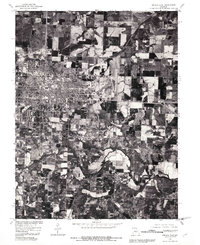 1980 Sedalia East1981 Print · USGSThe city of Sedalia is shown at a pivotal moment of growth in the early eighties, where urban development meets the Missouri prairie. Genealogists and researchers can trace the detailed street grid and land divisions near the winding Creek south of town.
 - 1980 Map of Sedalia West, 1981 Print
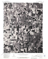 1980 Sedalia West1981 Print · USGSPettis County is captured during the early 1980s in this orthophotograph, showing the transition from urban edge to open farmland. Trace the 1980 footprint of Dresden and the western reaches of Sedalia alongside the waters of Muddy Creek.
 - 1983 Map of Sedalia
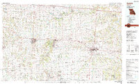 1983 Sedalia1983 Print · USGSWest Central Missouri's landscape in the early eighties shows a dense network of rail towns and riverside communities along the Blackwater River. Genealogists and historians can trace the development of Warrensburg and Sedalia near Whiteman Air Force Base and Knob Noster State Park.
End of results
Showing maps 1-3 of 3
Top cities of Pettis County
- Sedalia historical maps
- La Monte historical maps
- Smithton historical maps
- Green Ridge historical maps
- Houstonia historical maps
- Hughesville historical maps
Frequently asked questions
- What are the different types of historical maps available for Pettis County?
- What is the oldest map of Pettis County?
- Where can I purchase historical maps of Pettis County for my home or office?
- Where can I download high-res historical maps of Pettis County?
- Are there historical topographic maps available for Pettis County?
- Is there historical aerial imagery available for Pettis County?
- Where are historical maps of Pettis County sourced from?