1970s Maps of Pettis County, Missouri
Explore 9 historic maps of Pettis County from the 1970s. These maps offer a rare glimpse into what life looked like during the 1970s — showing old roads, neighborhoods, homes, and landmarks that have changed or disappeared over time.
Whether you're researching your family's past, planning a metal detecting trip, or studying how Pettis County's landscape evolved across the 1970s, these high-resolution maps are a powerful tool for exploring the history of this region.
- Focus on a specific era: All maps on this page are from the 1970s, giving you a focused view of this time period.
- See what’s changed: Compare century-old streets, trails, and buildings to today's modern landscape using overlays and satellite layers.
- Research with precision: Use these maps for genealogy, historical research, land use analysis, or educational projects.
- View, download, or print: Maps are fully viewable online in high resolution, and can be downloaded or printed for your own records.
Start exploring Pettis County's history through authentic maps from the 1970s. This is your window into the past.
Pettis County, MO maps
(9)- 1973 Map of Green Ridge North, 1974 Print
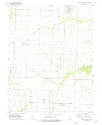
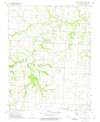 1973 Green Ridge North1974 Print · USGSPettis County, Missouri, is captured in the early 1970s as a landscape of established rail lines and winding prairie creeks. Genealogists and local historians can trace family locations near Old Hickory Point Cem, Rabourn Cem, and the village of Green Ridge.
 - 1973 Map of Hughesville, 1975 Print
 1973 Hughesville1975 Print · USGSPettis County in the early seventies shows a transition between traditional rail-connected towns and modern energy infrastructure. Genealogists and historians can trace family locations near Prairie Hill Cem, the Bethel Ch, or along the Old Railroad Grade.
 - 1973 Map of Houstonia, 1975 Print
 1973 Houstonia1975 Print · USGSHoustonia and the Blackwater River valley are captured here in the early seventies during a period of rural transition. Genealogists and local historians can trace family sites like Corinth Christ Ch, the Oak Grove Cem, and the path of an Old Railroad Grade.
 - 1973 Map of Ionia, 1975 Print
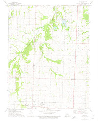 1973 Ionia1975 Print · USGSThe Pettis and Benton County line in the early 1970s shows a landscape of rail-dependent settlements and quiet rural cemeteries. Genealogists and local historians can locate Ionia, Manila, and the Christian Cemetery along the Chicago Rock Island and Pacific railroad.
 - 1973 Map of Sedalia East, 1975 Print
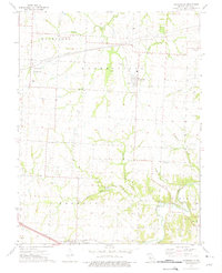
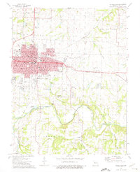 1973 Sedalia East1975 Print · USGSMid-century Sedalia is captured here as it expands east toward the regional airport and across the Missouri Pacific tracks. Genealogists and historians can trace numerous rural landmarks, including Crown Hill Cemetery, Goodwill Chapel, and the Striped College Sch.2 unique versions available
 - 1973 Map of La Monte, 1975 Print
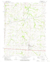 1973 La Monte1975 Print · USGSMid-Missouri prairie and creek bottoms define this area in the early seventies as the local economy centered on the rail line. Researchers can trace the layout of La Monte, the La Monte Cem, and the rural settlement at Stokley.
 - 1973 Map of Sweet Springs, 1975 Print
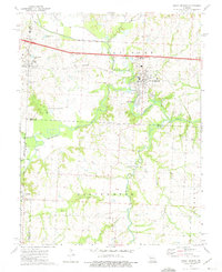 1973 Sweet Springs1975 Print · USGSSweet Springs and the surrounding Blackwater River valley are captured in the early 1970s during a period of rural stability. Researchers can trace family roots at Mt Zion Ch and Fairview Cem, or locate landmarks like Emma and the R-1 Sch.
 - 1973 Map of Sedalia West, 1975 Print
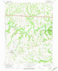
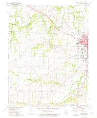 1973 Sedalia West1975 Print · USGSWestern Pettis County in the early seventies shows the growing edge of Sedalia as it meets the surrounding prairie and creek bottoms. Local researchers can trace old rail lines like the Missouri - Kansas - Texas, find rural landmarks like McKee Chapel, and locate family sites at Dresden Cem.
 - 1973 Map of Green Ridge South, 1975 Print
 1973 Green Ridge South1975 Print · USGSThe rural border of Pettis and Benton counties is captured here in the early 1970s, showcasing a landscape shaped by rail lines and winding creeks. Genealogists can trace family roots near Green Ridge or locate the Prairie Chapel Cemetery and the settlement of Brandon.
End of results
Showing maps 1-9 of 9
Top cities of Pettis County
- Sedalia historical maps
- La Monte historical maps
- Smithton historical maps
- Green Ridge historical maps
- Houstonia historical maps
- Hughesville historical maps
Frequently asked questions
- What are the different types of historical maps available for Pettis County?
- What is the oldest map of Pettis County?
- Where can I purchase historical maps of Pettis County for my home or office?
- Where can I download high-res historical maps of Pettis County?
- Are there historical topographic maps available for Pettis County?
- Is there historical aerial imagery available for Pettis County?
- Where are historical maps of Pettis County sourced from?