1990s Maps of Phelps County, Missouri
Explore 4 historic maps of Phelps County from the 1990s. These maps offer a rare glimpse into what life looked like during the 1990s — showing old roads, neighborhoods, homes, and landmarks that have changed or disappeared over time.
Whether you're researching your family's past, planning a metal detecting trip, or studying how Phelps County's landscape evolved across the 1990s, these high-resolution maps are a powerful tool for exploring the history of this region.
- Focus on a specific era: All maps on this page are from the 1990s, giving you a focused view of this time period.
- See what’s changed: Compare century-old streets, trails, and buildings to today's modern landscape using overlays and satellite layers.
- Research with precision: Use these maps for genealogy, historical research, land use analysis, or educational projects.
- View, download, or print: Maps are fully viewable online in high resolution, and can be downloaded or printed for your own records.
Start exploring Phelps County's history through authentic maps from the 1990s. This is your window into the past.
Phelps County, MO maps
(4)- 1992 Map of Lecoma, 1995 Print
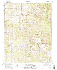 1992 Lecoma1995 Print · USGSThe Missouri Ozarks are captured here during the 1990s, revealing a landscape of winding ridges and deep cave systems. Researchers can trace rural settlement patterns through sites like Lecoma, Elk Prairie Ch, and the historic Charcoal Ovens.
 - 1992 Map of Rolla, 1995 Print
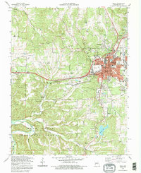 1992 Rolla1995 Print · USGSRolla and the surrounding Ozark foothills are documented here in the early nineties, showing a landscape defined by higher education and natural karst features. Researchers can locate dozens of historic family burial grounds like Brainard Cem, explore the outskirts of the Mark Twain National Forest, and trace local landmarks like Frisco Lake.
 - 1992 Map of Newburg, 1995 Print
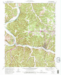 1992 Newburg1995 Print · USGSThe rail-and-river landscape of Phelps County is frozen in time during the early nineties as the ST LOUIS AND SAN FRANCISCO RR winds through the Ozarks. Genealogists can trace family names at Ramsey Cem or Goodall Cem and locate vanished river crossings like Whitehouse Ford.
 - 1992 Map of Dillon, 1995 Print
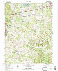 1992 Dillon1995 Print · USGSPhelps County in the early nineties shows a landscape of deep-set ridges and rail-side growth. Trace family history at Wishon Cem, the old tracks of the St Louis-San Francisco RR, or the small settlement at Dillon.
End of results
Showing maps 1-4 of 4
Top cities of Phelps County
- Rolla historical maps
- St. James historical maps
- Doolittle historical maps
- Newburg historical maps
- Edgar Springs historical maps
- Powellville historical maps
Frequently asked questions
- What are the different types of historical maps available for Phelps County?
- What is the oldest map of Phelps County?
- Where can I purchase historical maps of Phelps County for my home or office?
- Where can I download high-res historical maps of Phelps County?
- Are there historical topographic maps available for Phelps County?
- Is there historical aerial imagery available for Phelps County?
- Where are historical maps of Phelps County sourced from?