1930s Maps of Shannon County, Missouri
Explore 2 historic maps of Shannon County from the 1930s. These maps offer a rare glimpse into what life looked like during the 1930s — showing old roads, neighborhoods, homes, and landmarks that have changed or disappeared over time.
Whether you're researching your family's past, planning a metal detecting trip, or studying how Shannon County's landscape evolved across the 1930s, these high-resolution maps are a powerful tool for exploring the history of this region.
- Focus on a specific era: All maps on this page are from the 1930s, giving you a focused view of this time period.
- See what’s changed: Compare century-old streets, trails, and buildings to today's modern landscape using overlays and satellite layers.
- Research with precision: Use these maps for genealogy, historical research, land use analysis, or educational projects.
- View, download, or print: Maps are fully viewable online in high resolution, and can be downloaded or printed for your own records.
Start exploring Shannon County's history through authentic maps from the 1930s. This is your window into the past.
Shannon County, MO maps
(2)- 1931 Map of Bandyville
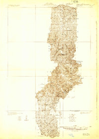 1931 Bandyville1931 Print · USGSThe Eleven Point River valley in the early 1930s remains a landscape of isolated rural townships and crossroads schools. Genealogists can trace family roots through sites like Falling Springs Cemetery, Hickory Grove Ch, and Bildad Sch.
 - 1932 Map of Cedar Grove
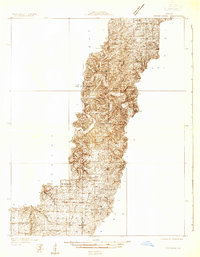 1932 Cedar Grove1932 Print · USGSShannon County and the surrounding Ozark highlands are captured in the early 1930s, showing a landscape of small timber-country settlements. Genealogists can trace family homesteads near Cedar Grove and several local schools like Black Valley Sch and Round Valley Sch.
End of results
Showing maps 1-2 of 2
Top cities of Shannon County
Frequently asked questions
- What are the different types of historical maps available for Shannon County?
- What is the oldest map of Shannon County?
- Where can I purchase historical maps of Shannon County for my home or office?
- Where can I download high-res historical maps of Shannon County?
- Are there historical topographic maps available for Shannon County?
- Is there historical aerial imagery available for Shannon County?
- Where are historical maps of Shannon County sourced from?