1990s Maps of Shannon County, Missouri
Explore 10 historic maps of Shannon County from the 1990s. These maps offer a rare glimpse into what life looked like during the 1990s — showing old roads, neighborhoods, homes, and landmarks that have changed or disappeared over time.
Whether you're researching your family's past, planning a metal detecting trip, or studying how Shannon County's landscape evolved across the 1990s, these high-resolution maps are a powerful tool for exploring the history of this region.
- Focus on a specific era: All maps on this page are from the 1990s, giving you a focused view of this time period.
- See what’s changed: Compare century-old streets, trails, and buildings to today's modern landscape using overlays and satellite layers.
- Research with precision: Use these maps for genealogy, historical research, land use analysis, or educational projects.
- View, download, or print: Maps are fully viewable online in high resolution, and can be downloaded or printed for your own records.
Start exploring Shannon County's history through authentic maps from the 1990s. This is your window into the past.
Shannon County, MO maps
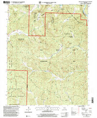
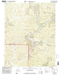
(10)- 1997 Map of Van Buren North, 1999 Print
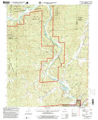 1997 Van Buren North1999 Print · USGSThe Missouri Ozarks are captured here in the late twentieth century as the region balanced conservation and local settlement. Genealogy researchers can trace family landmarks like Galbraith Cemetery and Bible Church near the Current River corridor.
 - 1997 Map of Bartlett, 1999 Print
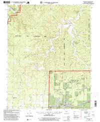 1997 Bartlett1999 Print · USGSShannon County in the late nineties is a landscape of protected timberlands and deep drainage hollows. Genealogists and local historians can trace family sites at Delaware Cemetery or locate the Manger of Bethlehem Church and the settlement of Bartlett.
 - 1997 Map of Fremont, 1999 Print
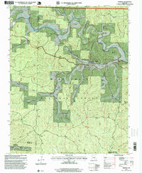 1997 Fremont1999 Print · USGSThe Ozark forest lands of Carter and Shannon counties appear here in the late nineties, documenting the industrial remains of the charcoal iron era. Researchers can locate numerous family burial grounds like New Hope Cemetery and trace the path of the Old Tram Road near the Site of Old Midco Iron Works.
 - 1997 Map of Winona, 1999 Print
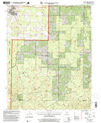
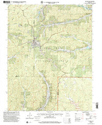
 1997 Winona1999 Print · USGSShannon County near the end of the century reveals a landscape where the town of Winona meets the sprawling Mark Twain National Forest. Researchers can trace old family sites and local history at Sutton Mine, Munsell, and the Williams Cemetery.
 - 1997 Map of Birch Tree, 1999 Print
 1997 Birch Tree1999 Print · USGSThe community of Birch Tree and the surrounding Ozark woodlands are documented here during the late nineties. Local researchers can locate family cemeteries, trace the courses of Hurricane Creek and Bee Fork, and identify landmarks like Fisher Pond and the Lookout Tower.
 - 1997 Map of Stegall Mountain, 2000 Print
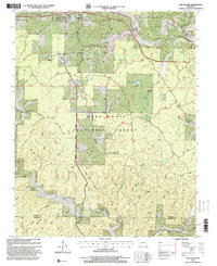
 1997 Stegall Mountain2000 Print · USGSShannon and Carter County terrain in the late twentieth century is defined by vast public lands and steep Ozark hollows. Researchers can locate Reed Cemetery, the Horner Church, and recreational landmarks like Rocky Falls and the Ozark Trail.
 - 1997 Map of Low Wassie, 2000 Print
 1997 Low Wassie2000 Print · USGSShannon County in the late nineties is documented here as the timber and water of the Missouri Ozarks meet at Winona. Researchers can trace the legacy of local industry and community via the Charcoal Kilns, Mount Zion Cemetery, and the Old Tram Road.
 - 1997 Map of Powder Mill Ferry, 2001 Print
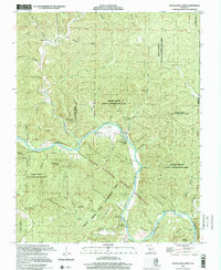 1997 Powder Mill Ferry2001 Print · USGSThe Shannon County riverfront is shown here in the late nineties, centered on the vital water crossings and natural springs of the Ozarks. Genealogists can trace family-named landmarks such as Peter Mooney Mountain and Clint Williams Spring, or locate the historic Powder Mill Ferry.
 - 1999 Map of Bunker, 2002 Print
 1999 Bunker2002 Print · USGSThe community of Bunker sits at the meeting point of three counties in the late nineties, surrounded by deep timber lands. Trace family sites at Estep Cem and Parks Cem, or locate landmarks like the Sawmill and the unique Turner Natural Bridge.
 - 1999 Map of Loggers Lake, 2002 Print
 1999 Loggers Lake2002 Print · USGSThe Ozark Highlands on the Dent and Shannon County border come alive in the late nineties, showcasing a landscape of managed timber and hidden hollows. Genealogists can trace family landmarks like Chatman Cem, Delmar Cem, and the waters of Aunt Sal Creek.
End of results
Showing maps 1-10 of 10
Top cities of Shannon County
Frequently asked questions
- What are the different types of historical maps available for Shannon County?
- What is the oldest map of Shannon County?
- Where can I purchase historical maps of Shannon County for my home or office?
- Where can I download high-res historical maps of Shannon County?
- Are there historical topographic maps available for Shannon County?
- Is there historical aerial imagery available for Shannon County?
- Where are historical maps of Shannon County sourced from?