1940s Maps of Stoddard County, Missouri
Explore 6 historic maps of Stoddard County from the 1940s. These maps offer a rare glimpse into what life looked like during the 1940s — showing old roads, neighborhoods, homes, and landmarks that have changed or disappeared over time.
Whether you're researching your family's past, planning a metal detecting trip, or studying how Stoddard County's landscape evolved across the 1940s, these high-resolution maps are a powerful tool for exploring the history of this region.
- Focus on a specific era: All maps on this page are from the 1940s, giving you a focused view of this time period.
- See what’s changed: Compare century-old streets, trails, and buildings to today's modern landscape using overlays and satellite layers.
- Research with precision: Use these maps for genealogy, historical research, land use analysis, or educational projects.
- View, download, or print: Maps are fully viewable online in high resolution, and can be downloaded or printed for your own records.
Start exploring Stoddard County's history through authentic maps from the 1940s. This is your window into the past.
Stoddard County, MO maps
(6)- 1940 Map of Malden, 1942 Print
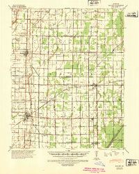 1940 Malden1942 Print · USGSIn the Missouri Bootheel during the early 1940s, a vast network of drainage ditches transformed the landscape for farming and rail commerce. Researchers can trace rural life through dozens of named landmarks like Sugar Tree Ch & Sch, Stephenson Cem, and Tallapoosa.
 - 1940 Map of Valley Ridge, 1943 Print
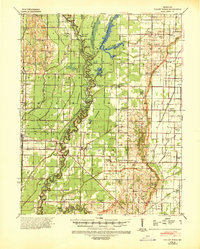 1940 Valley Ridge1943 Print · USGSDunklin and Butler counties come to life in the early 1940s, where the St Francis River winds through a landscape of new drainage ditches and high ridges. Researchers can locate family landmarks like Stephens Cem or trace old river crossings at Higginbothams Ferry.
 - 1949 Map of Paducah
 1949 Paducah1949 Print · USGSThe confluence of the Ohio, Mississippi, Tennessee, and Cumberland rivers at the close of the 1940s reveals a region bound by water and rail. Researchers can trace historic river landings, timberlands in the Shawnee National Forest, and the coal-mining infrastructure around West Frankfort and Herrin.2 unique versions available
 - 1949 Map of Rolla, 1950 Print
 1949 Rolla1950 Print · USGSThe Missouri Ozarks are captured here just after the war, showing a landscape of deep river valleys and emerging reservoir projects. Genealogists and historians can trace the mining towns of Bonne Terre and Potosi or follow the early route of U.S. Highway 66.
 - 1949 Map of Bloomfield, 1958 Print
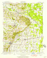 1949 Bloomfield1958 Print · USGSStoddard County is documented here during the post-war years as its agricultural drainage systems and rail networks reached their peak. Local historians can trace family roots through numerous rural landmarks like Dowdy Cem, Holly Ch, and the Walnut Ridge Sch.
 - 1949 Map of Poplar Bluff, 1964 Print
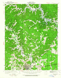 1949 Poplar Bluff1964 Print · USGSThe area surrounding Poplar Bluff is shown during a period of transition as the Ozark hills meet the engineered drainage canals of the lowlands. Researchers can trace the St Louis San Francisco railroad through rural stops like Chaonia and Taskee Sta.
End of results
Showing maps 1-6 of 6
Top cities of Stoddard County
- Dexter historical maps
- Bloomfield historical maps
- Bernie historical maps
- Advance historical maps
- Puxico historical maps
- Essex historical maps
See more
Frequently asked questions
- What are the different types of historical maps available for Stoddard County?
- What is the oldest map of Stoddard County?
- Where can I purchase historical maps of Stoddard County for my home or office?
- Where can I download high-res historical maps of Stoddard County?
- Are there historical topographic maps available for Stoddard County?
- Is there historical aerial imagery available for Stoddard County?
- Where are historical maps of Stoddard County sourced from?