1980s Maps of Stoddard County, Missouri
Explore 9 historic maps of Stoddard County from the 1980s. These maps offer a rare glimpse into what life looked like during the 1980s — showing old roads, neighborhoods, homes, and landmarks that have changed or disappeared over time.
Whether you're researching your family's past, planning a metal detecting trip, or studying how Stoddard County's landscape evolved across the 1980s, these high-resolution maps are a powerful tool for exploring the history of this region.
- Focus on a specific era: All maps on this page are from the 1980s, giving you a focused view of this time period.
- See what’s changed: Compare century-old streets, trails, and buildings to today's modern landscape using overlays and satellite layers.
- Research with precision: Use these maps for genealogy, historical research, land use analysis, or educational projects.
- View, download, or print: Maps are fully viewable online in high resolution, and can be downloaded or printed for your own records.
Start exploring Stoddard County's history through authentic maps from the 1980s. This is your window into the past.
Stoddard County, MO maps
(9)- 1983 Map of Poplar Bluff
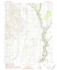
 1983 Poplar Bluff1983 Print · USGSSoutheast Missouri in the early 1980s reveals a landscape defined by the Ozark foothills and the complex drainage systems of the Bootheel. Researchers can trace the rail corridors of the Missouri Pacific RR through Poplar Bluff or locate rural sites like Wilhelmina Church and Lone Hill Lookout.
 - 1984 Map of Broseley
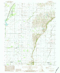
 1984 Broseley1984 Print · USGSSoutheast Missouri in the early eighties shows a landscape shaped by the St Francis River and extensive drainage projects. Genealogists and local historians can trace family locations near Broseley, Nyssa, and the high ground of Ash Hill.
 - 1984 Map of Powe
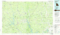
 1984 Powe1984 Print · USGSSoutheast Missouri in the early eighties shows a transition from wetland conservation to productive farmland. Trace local roots in Powe and Pyletown or explore the drainage systems of Main Ditch and the Otter Slough State Wildlife Management Area.
 - 1984 Map of Cape Girardeau, 1985 Print
 1984 Cape Girardeau1985 Print · USGSThe tri-state junction of Missouri, Illinois, and Kentucky in the mid-1980s was a bustling corridor defined by its massive river systems and complex rail lines. Researchers can trace the paths of the Missouri Pacific RR, explore the Shawnee National Forest, or locate small settlements like Marble Hill and Advance.
 - 1985 Map of Sikeston, 1986 Print
 1985 Sikeston1986 Print · USGSThe Missouri Bootheel and the four-state river convergence are captured in the mid-eighties as the modern agricultural and rail networks matured. Researchers can locate regional landmarks like the Towosahgy State Historic Site, Oak Grove Cem, and towns along the St Louis Southwestern Railroad.2 unique versions available
 - 1986 Map of Cape Girardeau
 1986 Cape Girardeau1986 Print · USGSThe Missouri-Illinois-Kentucky borderlands come into focus in the mid-1980s as the river-and-rail economy shapes the landscape near the Great Rivers confluence. Researchers can trace historic rail lines and old settlements like Gordonville, New Hamburg, and the Trail of Tears State Park.
 - 1986 Map of Piedmont
 1986 Piedmont1986 Print · USGSThe Missouri Ozarks are captured here in the mid-eighties as a region of dense state forests and critical river management. Genealogists and historians can trace family-named features and rural settlements like Piedmont, Lesterville, and the Yokum School.2 unique versions available
 - 1987 Map of Paducah, 1988 Print
 1987 Paducah1988 Print · USGSThe Lower Ohio Valley and the Illinois Ozarks come alive in this late twentieth-century regional survey. Genealogists and local historians can trace river-town roots and state park landmarks from Metropolis to Cape Girardeau and Trail of Tears State Park.
 - 1989 Map of Rolla
 1989 Rolla1989 Print · USGSThe Missouri Ozarks are captured in the late eighties as a landscape of national forests and historic mining towns. Researchers can trace the rail lines of the Missouri Pacific RR or locate landmarks like Taum Sauk Mtn and Elephant Rocks State Park.
End of results
Showing maps 1-9 of 9
Top cities of Stoddard County
- Dexter historical maps
- Bloomfield historical maps
- Bernie historical maps
- Advance historical maps
- Puxico historical maps
- Essex historical maps
See more
Frequently asked questions
- What are the different types of historical maps available for Stoddard County?
- What is the oldest map of Stoddard County?
- Where can I purchase historical maps of Stoddard County for my home or office?
- Where can I download high-res historical maps of Stoddard County?
- Are there historical topographic maps available for Stoddard County?
- Is there historical aerial imagery available for Stoddard County?
- Where are historical maps of Stoddard County sourced from?