1910s Maps of Big Horn County, Montana
Explore 2 historic maps of Big Horn County from the 1910s. These maps offer a rare glimpse into what life looked like during the 1910s — showing old roads, neighborhoods, homes, and landmarks that have changed or disappeared over time.
Whether you're researching your family's past, planning a metal detecting trip, or studying how Big Horn County's landscape evolved across the 1910s, these high-resolution maps are a powerful tool for exploring the history of this region.
- Focus on a specific era: All maps on this page are from the 1910s, giving you a focused view of this time period.
- See what’s changed: Compare century-old streets, trails, and buildings to today's modern landscape using overlays and satellite layers.
- Research with precision: Use these maps for genealogy, historical research, land use analysis, or educational projects.
- View, download, or print: Maps are fully viewable online in high resolution, and can be downloaded or printed for your own records.
Start exploring Big Horn County's history through authentic maps from the 1910s. This is your window into the past.
Big Horn County, MT maps
(2)- 1911 Map of Sheridan
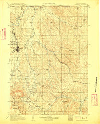 1911 Sheridan1911 Print · USGSSheridan and the surrounding northern Wyoming ranchlands are captured here during a period of rapid railroad expansion. Researchers can trace the Chicago Burlington and Quincy RR through Dietz and Verona, or locate early homesteads like Wagoner Ranch.2 unique versions available
 - 1915 Map of Spenceville, 1947 Print
 1915 Spenceville1947 Print · USGSThe foothills of the Sierra Nevada are captured here in the early twentieth century as a landscape of large ranchos and winding river canyons. Genealogists and historians can trace the paths of Dry Creek and locate historical transit points like McCourtney Crossing and the Johnson Rancho.
End of results
Showing maps 1-2 of 2
Top cities of Big Horn County
- Hardin historical maps
- Busby District historical maps
- Pryor historical maps
- Lodge Grass historical maps
- Garryowen historical maps
Frequently asked questions
- What are the different types of historical maps available for Big Horn County?
- What is the oldest map of Big Horn County?
- Where can I purchase historical maps of Big Horn County for my home or office?
- Where can I download high-res historical maps of Big Horn County?
- Are there historical topographic maps available for Big Horn County?
- Is there historical aerial imagery available for Big Horn County?
- Where are historical maps of Big Horn County sourced from?