1970s Maps of Broadwater County, Montana
Explore 10 historic maps of Broadwater County from the 1970s. These maps offer a rare glimpse into what life looked like during the 1970s — showing old roads, neighborhoods, homes, and landmarks that have changed or disappeared over time.
Whether you're researching your family's past, planning a metal detecting trip, or studying how Broadwater County's landscape evolved across the 1970s, these high-resolution maps are a powerful tool for exploring the history of this region.
- Focus on a specific era: All maps on this page are from the 1970s, giving you a focused view of this time period.
- See what’s changed: Compare century-old streets, trails, and buildings to today's modern landscape using overlays and satellite layers.
- Research with precision: Use these maps for genealogy, historical research, land use analysis, or educational projects.
- View, download, or print: Maps are fully viewable online in high resolution, and can be downloaded or printed for your own records.
Start exploring Broadwater County's history through authentic maps from the 1970s. This is your window into the past.
Broadwater County, MT maps
(10)- 1971 Map of Battle Mountain, 1974 Print
 1971 Battle Mountain1974 Print · USGSMeagher County in the early 1970s shows a landscape of high-mountain recreation and forest management. Hikers and historians can trace the paths through Klondike Pass, the slopes of the Grass Mountain Ski Area, and primitive routes like the Pack Trail near Battle Mountain.
 - 1971 Map of Mount Edith, 1975 Print
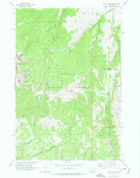 1971 Mount Edith1975 Print · USGSThe high Big Belt Mountains come into focus in the early 1970s, showing the rugged boundary between Broadwater and Meagher counties. Modern explorers can trace trails to Edith Lake or locate old Prospect sites near Holloway Gulch.3 unique versions available
 - 1971 Map of Sulphur Bar Creek, 1975 Print
 1971 Sulphur Bar Creek1975 Print · USGSBroadwater County in the early 1970s was a landscape of remote mountain passes and ancient routes within the Helena National Forest. Researchers can trace the path of the Flathead Indian Trail and locate historical landmarks like Munding Flat and Black Butte.
 - 1971 Map of Alkali Lake, 1975 Print
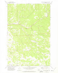
 1971 Alkali Lake1975 Print · USGSMeagher County ranching and forest lands are captured here in the early 1970s. Trace the layout of the Springdale Colony and its nearby Cem, or follow the Jeep Trail as it climbs toward the timber of the Helena National Forest.
 - 1972 Map of Canyon Ferry SW, 1975 Print
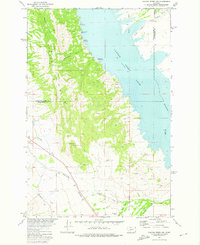 1972 Canyon Ferry SW1975 Print · USGSThe eastern Spokane Hills meet the waters of the Missouri River in the early seventies, showing a landscape shaped by both recreation and industry. Researchers can trace the Burlington Northern line or locate family history at Winston Cem and Potter Dam.
 - 1972 Map of Canyon Ferry SE, 1975 Print
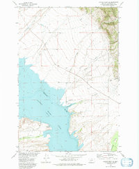 1972 Canyon Ferry SE1975 Print · USGSThe Missouri River basin in Broadwater County is shown here in the early seventies, detailing the rising waters of Canyon Ferry Lake. Researchers can locate old mining signs like Confederate Gulch and the landing at Goose Bay.
 - 1972 Map of Canyon Ferry, 1976 Print
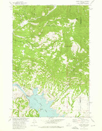 1972 Canyon Ferry1976 Print · USGSThe Missouri River corridor near the Lewis and Clark and Broadwater county line is shown here in the early 1970s. Trace the industrial footprint of the Golden Messenger Mine or locate early recreation sites like the Court Sheriff Recreation Area and Canyon Ferry Dam.2 unique versions available
 - 1972 Map of Hellgate Gulch, 1976 Print
 1972 Hellgate Gulch1976 Print · USGSThe Big Belt Mountains within Helena National Forest appear here in the early 1970s, showing a land of steep gulches and isolated pack trails. Researchers can trace historic access and mining efforts via numerous prospects and rugged routes like Kilgallon Gulch and Never Sweat Gulch.2 unique versions available
 - 1975 Map of Canyon Ferry Dam, 1994 Print
 1975 Canyon Ferry Dam1994 Print · USGSThe Missouri River and Big Belt Mountains define this Montana landscape during the mid-seventies. Genealogists and historians can trace old mining sites like the Snowback Mine and industrial settlements including White City and Louisville.
 - 1976 Map of Townsend, 1994 Print
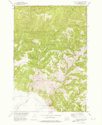
 1976 Townsend1994 Print · USGSBroadwater County and the surrounding peaks come into focus during the mid-seventies, showing the intersection of heavy mining history and mountain wilderness. Genealogists and historians can trace the foundations of Radersburg, the remote rail junction at Lombard, and dozens of named claims like the East Pacific Mine.
End of results
Showing maps 1-10 of 10
Top cities of Broadwater County
Frequently asked questions
- What are the different types of historical maps available for Broadwater County?
- What is the oldest map of Broadwater County?
- Where can I purchase historical maps of Broadwater County for my home or office?
- Where can I download high-res historical maps of Broadwater County?
- Are there historical topographic maps available for Broadwater County?
- Is there historical aerial imagery available for Broadwater County?
- Where are historical maps of Broadwater County sourced from?