1950s Maps of Meagher County, Montana
Explore 10 historic maps of Meagher County from the 1950s. These maps offer a rare glimpse into what life looked like during the 1950s — showing old roads, neighborhoods, homes, and landmarks that have changed or disappeared over time.
Whether you're researching your family's past, planning a metal detecting trip, or studying how Meagher County's landscape evolved across the 1950s, these high-resolution maps are a powerful tool for exploring the history of this region.
- Focus on a specific era: All maps on this page are from the 1950s, giving you a focused view of this time period.
- See what’s changed: Compare century-old streets, trails, and buildings to today's modern landscape using overlays and satellite layers.
- Research with precision: Use these maps for genealogy, historical research, land use analysis, or educational projects.
- View, download, or print: Maps are fully viewable online in high resolution, and can be downloaded or printed for your own records.
Start exploring Meagher County's history through authentic maps from the 1950s. This is your window into the past.
Meagher County, MT maps
(10)- 1950 Map of Duck Creek Pass, 1953 Print
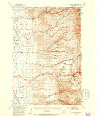 1950 Duck Creek Pass1953 Print · USGSBroadwater County ranching and mining sites appear in detail during the early postwar era as the landscape shifted. Genealogists can locate family holdings like Merritt Ranch, several Gold Mines, and the Holy Cross Cem near the Missouri River.4 unique versions available
 - 1951 Map of Sixteen NE, 1952 Print
 1951 Sixteen NE1952 Print · USGSThe ranching country of central Montana is captured here just after mid-century as homesteads were consolidating. Genealogists and historians can trace family landmarks and land-use shifts through sites like Campbell Ranch, Heath Ranch, and the Oil Well on Elk Ridge.3 unique versions available
 - 1951 Map of Hamen, 1953 Print
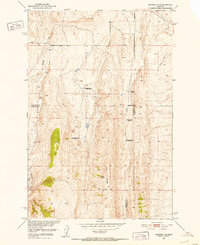
 1951 Hamen1953 Print · USGSMeagher County ranching life and the northern rail corridor are documented here during the early fifties. Genealogists and local historians can locate several family-named landmarks including Tip Top School, Loweth, and the Higgins Ranch.4 unique versions available
 - 1951 Map of Wolf Hill, 1953 Print
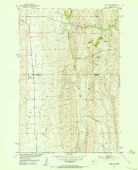 1951 Wolf Hill1953 Print · USGSThe high country of Park and Meagher Counties is captured here in the early fifties, showing a ranching landscape in transition. Genealogists and historians can locate legacy homesteads like Arthur Ranch alongside industrial remnants such as an Oil Well (Abnd) and Coal Mine (Abnd).2 unique versions available
 - 1951 Map of Ringling, 1953 Print
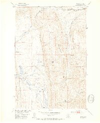
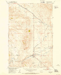 1951 Ringling1953 Print · USGSMeagher County ranching and rail travel intersect in the early fifties as the Milwaukee Road follows the creek through this Montana landscape. Genealogists can trace family holdings at the Adkison Ranch and Higgins Ranch or locate the Moss Agate stage site.3 unique versions available
 - 1951 Map of Black Butte Mountain, 1953 Print
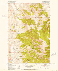
 1951 Black Butte Mountain1953 Print · USGSMeagher County ranching and resource development are captured here in the early 1950s during the Missouri River Basin project. Genealogists and historians can locate family landmarks like J Stewart Ranch and Prescott Ranch, or trace the vicinity of a Copper Mine near Battle Creek.3 unique versions available
 - 1951 Map of Rimrock Divide, 1953 Print
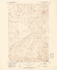
 1951 Rimrock Divide1953 Print · USGSThe Crazy Mountains in the early fifties reveal a landscape of remote timber claims and high-country ranching. Genealogists can trace family legacies through the Rostad Ranch and abandoned sites like the Hoyem Homestead or Bill Bracket Place.2 unique versions available
 - 1954 Map of Great Falls
 1954 Great Falls1954 Print · USGSThe Missouri River valley in the mid-1950s is shown at a time of significant industrial and military growth. Genealogists and historians can locate early schools and rail stops like Tiger Butte Community Center, Fort Benton, and the Anaconda Wire Plant.4 unique versions available
 - 1957 Map of Great Falls
 1957 Great Falls1957 Print · USGSMontana's central plains and mountain foothills are captured here in the mid-fifties, showing the hub of Great Falls and the surrounding grain-shipping towns. Genealogists can trace family roots through the rail sidings of the Great Northern and small rural communities like Sand Coulee or Fort Benton.
 - 1958 Map of White Sulphur Springs, 1968 Print
 1958 White Sulphur Springs1968 Print · USGSCentral Montana in the late fifties was a landscape of high-country mining and newly formed reservoirs. You can trace the rail-and-river economy of the era through sites like Canyon Ferry Lake, the East Pacific Mine, and the historic Fort Logan.3 unique versions available
End of results
Showing maps 1-10 of 10
Top cities of Meagher County
Frequently asked questions
- What are the different types of historical maps available for Meagher County?
- What is the oldest map of Meagher County?
- Where can I purchase historical maps of Meagher County for my home or office?
- Where can I download high-res historical maps of Meagher County?
- Are there historical topographic maps available for Meagher County?
- Is there historical aerial imagery available for Meagher County?
- Where are historical maps of Meagher County sourced from?