1940s Maps of Meagher County, Montana
Explore 3 historic maps of Meagher County from the 1940s. These maps offer a rare glimpse into what life looked like during the 1940s — showing old roads, neighborhoods, homes, and landmarks that have changed or disappeared over time.
Whether you're researching your family's past, planning a metal detecting trip, or studying how Meagher County's landscape evolved across the 1940s, these high-resolution maps are a powerful tool for exploring the history of this region.
- Focus on a specific era: All maps on this page are from the 1940s, giving you a focused view of this time period.
- See what’s changed: Compare century-old streets, trails, and buildings to today's modern landscape using overlays and satellite layers.
- Research with precision: Use these maps for genealogy, historical research, land use analysis, or educational projects.
- View, download, or print: Maps are fully viewable online in high resolution, and can be downloaded or printed for your own records.
Start exploring Meagher County's history through authentic maps from the 1940s. This is your window into the past.
Meagher County, MT maps
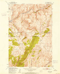
(3)- 1948 Map of White Sulphur Springs, 1951 Print
 1948 White Sulphur Springs1951 Print · USGSMontana's capital and the high country of the Big Belt Mountains come alive in this mid-century survey. Trace the early hydroelectric developments at Canyon Ferry Dam or follow the historic rail lines through Ringling and Townsend.
 - 1948 Map of Sixteen, 1953 Print
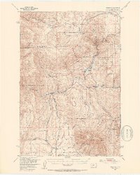
 1948 Sixteen1953 Print · USGSThe Gallatin County high country is shown here in the late 1940s as a vital corridor for the Milwaukee Road railroad. Genealogists and historians can trace the isolated settlement of Sixteen and the Robertson Ranch nestled among the peaks of Elkhorn Ridge.3 unique versions available
 - 1949 Map of Maudlow, 1954 Print
 1949 Maudlow1954 Print · USGSGallatin County ranching and railroad life are preserved here in the late 1940s as the high peaks meet the rail lines. Genealogists and historians can trace family landmarks like the Morgan Cemetery, Francis School, and the remote settlement of Maudlow.4 unique versions available
End of results
Showing maps 1-3 of 3
Top cities of Meagher County
Frequently asked questions
- What are the different types of historical maps available for Meagher County?
- What is the oldest map of Meagher County?
- Where can I purchase historical maps of Meagher County for my home or office?
- Where can I download high-res historical maps of Meagher County?
- Are there historical topographic maps available for Meagher County?
- Is there historical aerial imagery available for Meagher County?
- Where are historical maps of Meagher County sourced from?