1980s Maps of Meagher County, Montana
Explore 4 historic maps of Meagher County from the 1980s. These maps offer a rare glimpse into what life looked like during the 1980s — showing old roads, neighborhoods, homes, and landmarks that have changed or disappeared over time.
Whether you're researching your family's past, planning a metal detecting trip, or studying how Meagher County's landscape evolved across the 1980s, these high-resolution maps are a powerful tool for exploring the history of this region.
- Focus on a specific era: All maps on this page are from the 1980s, giving you a focused view of this time period.
- See what’s changed: Compare century-old streets, trails, and buildings to today's modern landscape using overlays and satellite layers.
- Research with precision: Use these maps for genealogy, historical research, land use analysis, or educational projects.
- View, download, or print: Maps are fully viewable online in high resolution, and can be downloaded or printed for your own records.
Start exploring Meagher County's history through authentic maps from the 1980s. This is your window into the past.
Meagher County, MT maps
(4)- 1984 Map of Belt
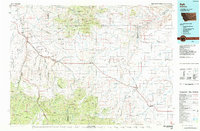 1984 Belt1984 Print · USGSCentral Montana's high peaks and ranching benches are captured here in the early 1980s, documenting the region's mining and rail heritage. Genealogists and historians can locate remote mining outposts like Hughesville and Barker, or trace the Burlington Northern Railroad through Belt and Stanford.
 - 1984 Map of White Sulphur Springs
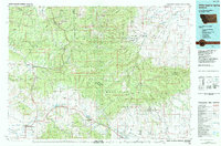 1984 White Sulphur Springs1984 Print · USGSCentral Montana's mining and ranching corridors come to life in the mid-eighties, highlighting the high-country settlements of the Meagher and Judith Basin counties. Genealogists and historians can trace old mining claims like the Silver Dyke Mine and Broadwater Mines, or locate remote points like Checkerboard and Neihart.
 - 1986 Map of Gurnett Creek East
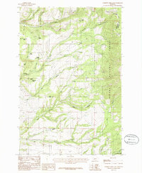 1986 Gurnett Creek East1986 Print · USGSThe Big Belt Mountains of Broadwater and Meagher counties are mapped in the mid-1980s as a landscape of timber and ranching. Trace family-named landmarks and water sources like Hooligans Hill, Hard Cash Spring, and Duck Creek Pass.
 - 1986 Map of Francis
 1986 Francis1986 Print · USGSThe mountains of Meagher, Broadwater, and Gallatin counties are shown here in the mid-eighties as a hub of early rail engineering. You can trace the Old Railroad Grade past Francis and follow the steep drainages of Sixteenmile Creek and Paddox Run.
End of results
Showing maps 1-4 of 4
Top cities of Meagher County
Frequently asked questions
- What are the different types of historical maps available for Meagher County?
- What is the oldest map of Meagher County?
- Where can I purchase historical maps of Meagher County for my home or office?
- Where can I download high-res historical maps of Meagher County?
- Are there historical topographic maps available for Meagher County?
- Is there historical aerial imagery available for Meagher County?
- Where are historical maps of Meagher County sourced from?