1970s Maps of Musselshell County, Montana
Explore 16 historic maps of Musselshell County from the 1970s. These maps offer a rare glimpse into what life looked like during the 1970s — showing old roads, neighborhoods, homes, and landmarks that have changed or disappeared over time.
Whether you're researching your family's past, planning a metal detecting trip, or studying how Musselshell County's landscape evolved across the 1970s, these high-resolution maps are a powerful tool for exploring the history of this region.
- Focus on a specific era: All maps on this page are from the 1970s, giving you a focused view of this time period.
- See what’s changed: Compare century-old streets, trails, and buildings to today's modern landscape using overlays and satellite layers.
- Research with precision: Use these maps for genealogy, historical research, land use analysis, or educational projects.
- View, download, or print: Maps are fully viewable online in high resolution, and can be downloaded or printed for your own records.
Start exploring Musselshell County's history through authentic maps from the 1970s. This is your window into the past.
Musselshell County, MT maps
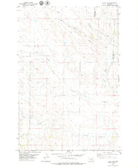
(16)- 1970 Map of South Bench, 1973 Print
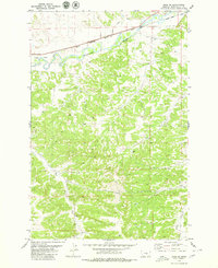
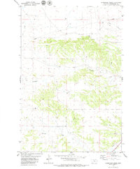
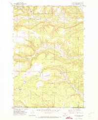 1970 South Bench1973 Print · USGSFergus and Golden Valley counties in the early seventies reveal a high-plains landscape where the Little Snowy Mountains meet the central Montana benches. Researchers can trace land use near Ashbridge Spring, locate a remote Cem, and explore the headwaters of North Fork Flatwillow Creek.
 - 1979 Map of Roundup
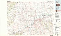
 1979 Roundup1979 Print · USGSCentral Montana at the close of the 1970s reveals a landscape defined by coal mining and major rail lines. Researchers can trace the industrial legacy of Roundup and Klein or locate landmarks like the Western Mine and Steamboat Butte.
 - 1979 Map of Bundy
 1979 Bundy1979 Print · USGSCentral Montana cattle and rail country is captured here in the late seventies as the river and railway define local life. Genealogists and historians can trace the irrigation systems of Glennie Ditch, the railroad siding at Bundy, and the rugged terrain of Painted Robe.
 - 1979 Map of Melstone
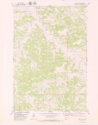
 1979 Melstone1979 Print · USGSThe ranching and rail corridors of central Montana are preserved in this late 1970s survey. Genealogists and historians can trace the Milwaukee Road through settlements like Melstone, Ingomar, and Sumatra along the Musselshell River.
 - 1979 Map of Lavina NW
 1979 Lavina NW1979 Print · USGSGolden Valley and Musselshell Counties in the late seventies show a landscape shaped by drainage and light industry. Researchers can trace the path of a major Pipeline, locate several Gravel Pits, and follow the winding courses of Currant Creek and Twin Coulee.
 - 1979 Map of Corey Flat
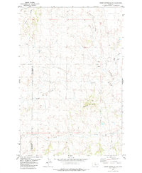
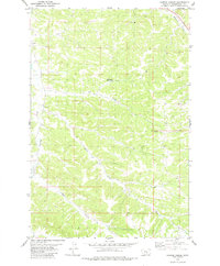
 1979 Corey Flat1979 Print · USGSMusselshell County, Montana, is captured in the late seventies as a land of ranching and resource extraction. Researchers can trace land use through distinctive markers like the Musselshell Cem, the Flowing Well, and various Mines near Hawk Creek.2 unique versions available
 - 1979 Map of Hysham
 1979 Hysham1979 Print · USGSBig Sky cattle country and river-fed valleys define this 1970s Montana landscape at the junction of two major rivers. Genealogists and historians can trace rail-side towns like Hysham, Myers, and Sanders, or locate family landmarks near Pease Bottom and Bull Mtn.
 - 1979 Map of Timber Buttes South, 1980 Print
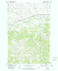
 1979 Timber Buttes South1980 Print · USGSThe Musselshell and Golden Valley county line is captured in the late seventies, showing a landscape defined by ranching and mineral potential. Trace the drainage paths of Pole Creek and Cameron Creek or locate landmarks like Timber Buttes and the local Gravel Pit.
 - 1979 Map of Gage NE, 1980 Print
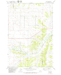
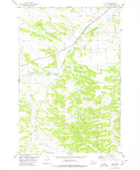
 1979 Gage NE1980 Print · USGSMusselshell County during the late 1970s reveals a landscape defined by the Musselshell River and the Chicago Milwaukee St Paul and Pacific rail line. Researchers can trace irrigation systems like the Krueger Spendiff Ditch and local landmarks such as Y Bar Coulee.
 - 1979 Map of Harper Coulee, 1980 Print
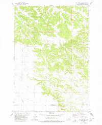
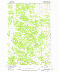
 1979 Harper Coulee1980 Print · USGSMusselshell County ranching and water management are detailed in the late seventies. Researchers can trace land use patterns and vital water sources like Thompsons Water Hole, Harper Coulee, and the drainage of Halfbreed Creek.
 - 1979 Map of Elso, 1980 Print
 1979 Elso1980 Print · USGSMusselshell County during the late seventies shows a landscape where the Milwaukee Road defines the river valley. Researchers can trace the water infrastructure of Naderman Dam, the local Cem, and the rail siding at Elso.
 - 1979 Map of Hay Basin NE, 1980 Print
 1979 Hay Basin NE1980 Print · USGSMusselshell and Yellowstone counties meet in this 1970s survey of the Bull Mountains upland. Researchers can trace the industrial footprint of the Berten Mine and Antelope Mine alongside the winding Goulding Creek.
 - 1979 Map of Horsethief Creek, 1980 Print
 1979 Horsethief Creek1980 Print · USGSMusselshell County in the late 1970s shows a landscape balancing rail transport with rising energy development. You can trace the path of the CM ST P & P railroad near Naderman and locate numerous resource sites like the Gravel Pit and wells along Horsethief Creek.
 - 1979 Map of Chimney Butte, 1980 Print
 1979 Chimney Butte1980 Print · USGSMusselshell County ranching and resource lands are captured here in the late seventies, showing a landscape defined by natural coulees. Trace family history or land use across Chimney Butte, Fattig Creek, and Y Bar Coulee.
 - 1979 Map of Gage, 1987 Print
 1979 Gage1987 Print · USGSMusselshell County ranching and mining were in full swing during the late seventies. Researchers can trace the industrial footprint of the Jeffries Mine and Western Mine along the Musselshell River and the old Milwaukee Road rail line.
 - 1979 Map of Roundup, 1993 Print
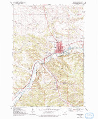 1979 Roundup1993 Print · USGSRoundup and the Musselshell River valley appear in the late 1970s as a landscape shaped by coal mining and central Montana ranching. Genealogists and historians can trace the mining settlements of Klein, Gibbtown, and Farreltown or locate rural operations like the Square Deal Mine.
End of results
Showing maps 1-16 of 16
Top cities of Musselshell County
Frequently asked questions
- What are the different types of historical maps available for Musselshell County?
- What is the oldest map of Musselshell County?
- Where can I purchase historical maps of Musselshell County for my home or office?
- Where can I download high-res historical maps of Musselshell County?
- Are there historical topographic maps available for Musselshell County?
- Is there historical aerial imagery available for Musselshell County?
- Where are historical maps of Musselshell County sourced from?