1980s Maps of Park County, Montana
Explore 51 historic maps of Park County from the 1980s. These maps offer a rare glimpse into what life looked like during the 1980s — showing old roads, neighborhoods, homes, and landmarks that have changed or disappeared over time.
Whether you're researching your family's past, planning a metal detecting trip, or studying how Park County's landscape evolved across the 1980s, these high-resolution maps are a powerful tool for exploring the history of this region.
- Focus on a specific era: All maps on this page are from the 1980s, giving you a focused view of this time period.
- See what’s changed: Compare century-old streets, trails, and buildings to today's modern landscape using overlays and satellite layers.
- Research with precision: Use these maps for genealogy, historical research, land use analysis, or educational projects.
- View, download, or print: Maps are fully viewable online in high resolution, and can be downloaded or printed for your own records.
Start exploring Park County's history through authentic maps from the 1980s. This is your window into the past.
Park County, MT maps
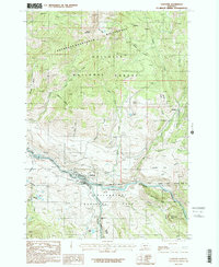
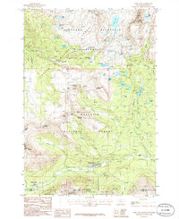
(51)- 1983 Map of Yellowstone National Park North
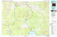 1983 Yellowstone National Park North1983 Print · USGSThe northern wilderness of Wyoming and Montana is captured here in the early eighties, documenting the geothermal landmarks and early visitor infrastructure. Trace the historic paths of the Howard Eaton Trail or locate park icons like Mammoth Hot Springs and the Lake Hotel.
 - 1986 Map of Dome Mountain
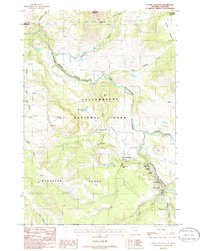
 1986 Dome Mountain1986 Print · USGSParadise Valley and the Yellowstone River corridor are captured in the mid-eighties as they cut through the Gallatin National Forest. You can trace the Old Railroad Grade through Yankee Jim Canyon and locate high-country landmarks like Sphinx Mountain.
 - 1986 Map of Little Park Mountain
 1986 Little Park Mountain1986 Print · USGSThe high Beartooth wilderness in the mid-1980s reveals a landscape of permanent ice and alpine lakes. Hikers and researchers can trace the extent of Wolf Glacier, locate the high Guard Sta, and follow the Stillwater River headwaters.
 - 1986 Map of Blacktail Deer Creek
 1986 Blacktail Deer Creek1986 Print · USGSYellowstone's northern backcountry comes into focus in the mid-1980s, documenting the rugged drainage of the Yellowstone River at the Montana Wyoming border. Trace primitive travel routes like the Pack Trail and locate natural landmarks including Wraith Falls and Phantom Lake.
 - 1986 Map of Granite Peak
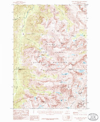
 1986 Granite Peak1986 Print · USGSThe high Beartooth range in the mid-1980s is captured here in a period of pristine wilderness and glacial study. Researchers can trace the rugged topography of Granite Peak and the surrounding ice fields like Granite Glacier and Hidden Glacier.2 unique versions available
 - 1986 Map of Gardiner
 1986 Gardiner1986 Print · USGSGardiner and the northern entrance of Yellowstone National Park appear in high detail during the mid-eighties as a hub of mountain recreation and mining. Researchers can trace the Landslide Grade, locate the Cem near Jardine, and find the isolated Quarries dotting the Gallatin slopes.2 unique versions available
 - 1986 Map of Lamar Canyon
 1986 Lamar Canyon1986 Print · USGSYellowstone's wilderness is captured in the mid-eighties as it transitions from the high Buffalo Plateau to the valley floor. Researchers can trace the Pack Trail network near Slough Creek or locate the Corral and Gravel Pit along the Lamar River.2 unique versions available
 - 1986 Map of Pinnacle Mountain
 1986 Pinnacle Mountain1986 Print · USGSThe high Beartooth Range comes into sharp focus in the mid-eighties as three Montana counties meet in a landscape of alpine lakes and peaks. Trace the remote headwaters of the Stillwater River and find isolated landmarks like Lake of the Woods, Pinnacle Mountain, and Horseshoe Basin.
 - 1986 Map of Miner
 1986 Miner1986 Print · USGSThe Yellowstone River corridor and Gallatin National Forest appear here in the mid-1980s, documenting a landscape of high peaks and remote basins. Researchers can trace the Old Railroad Grade through Yankee Jim Canyon or locate Stoughten and Merrell Lake.
 - 1986 Map of Quadrant Mountain
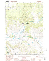
 1986 Quadrant Mountain1986 Print · USGSYellowstone's high backcountry comes into focus during the mid-eighties as it straddles the Wyoming and Montana line. Researchers can trace remote trails and landmarks from Sepulcher Mountain to the depths of Gardner Hole and the source of Indian Creek.
 - 1986 Map of Mammoth
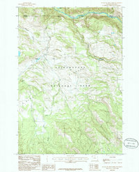
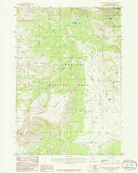
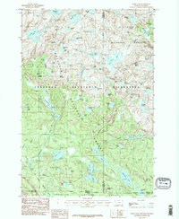
 1986 Mammoth1986 Print · USGSYellowstone’s northern gateway and geothermal heart are captured here in the mid-eighties, showing the administrative and natural landscape at Mammoth. Researchers can locate specific travertine formations like Main Terrace or trace old routes through Kingman Pass and past Swan Lake.2 unique versions available
 - 1986 Map of Cooke City
 1986 Cooke City1986 Print · USGSIn the mid-1980s, the mountain mining landscape of Cooke City remained a hive of alpine activity at the intersection of three National Forests. Researchers can trace historic extraction sites like the Open Pit Mine near Daisy Pass and local landmarks including the Cem and Miller Mountain.
 - 1986 Map of Tower Junction
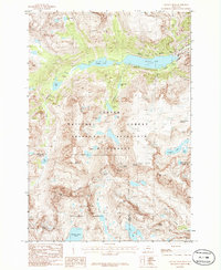
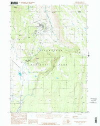
 1986 Tower Junction1986 Print · USGSUpper Yellowstone Park in the mid-1980s reveals a wilderness of thermal springs and early backcountry routes. Trace historic locations like Yanceys and Tower Junction alongside natural wonders including Tower Fall and the Petrified Tree.2 unique versions available
 - 1986 Map of Electric Peak
 1986 Electric Peak1986 Print · USGSThe high peaks and river canyons of the Montana-Wyoming border appear here during the mid-eighties as a mix of protected wilderness and industrial heritage. Researchers can trace the Old Railroad Grade, locate historic Coke Ovens, and find the Cemetery near Aldridge Lake.
 - 1986 Map of Ramshorn Peak
 1986 Ramshorn Peak1986 Print · USGSThe Gallatin Range in the mid-1980s is captured here, showing a landscape of high summits and protected forests before modern development. Trace mountain trails and remote landmarks like Ramshorn Peak, Lake Elsie, and the Buffalo Horn Pass.2 unique versions available
 - 1986 Map of Fossil Lake
 1986 Fossil Lake1986 Print · USGSThe high mountain reaches of the Montana-Wyoming border appear in this 1980s survey, documenting the point where three National Forests meet. Trace high-altitude landmarks like Fossil Lake, Mount Rosebud, and the winding Pack Trail through the Absaroka-Beartooth Wilderness.2 unique versions available
 - 1986 Map of Big Horn Peak
 1986 Big Horn Peak1986 Print · USGSThe Montana and Wyoming borderlands are preserved in this mid-eighties survey of high mountain wilderness. Trekkers and historians can trace old routes like the Petrified Forest Pack Trail past Big Horn Peak and Lava Butte.
 - 1986 Map of Sportsman Lake, 1987 Print
 1986 Sportsman Lake1987 Print · USGSThe Montana-Wyoming border wilderness comes alive in this mid-eighties survey of high-country drainage basins and remote summits. Trace the network of Pack Trails connecting Sportsman Lake, Sawtooth Mountain, and the headwaters of Specimen Creek.
 - 1987 Map of Hummingbird Peak
 1987 Hummingbird Peak1987 Print · USGSThe high backcountry of the Montana-Wyoming border is captured here in the late 1980s as it transitions into the northern reach of Yellowstone. Backcountry researchers can locate remote outposts like the Buffalo Plateau Patrol Cabin and the Poacher Trail.
 - 1987 Map of Bald Knob
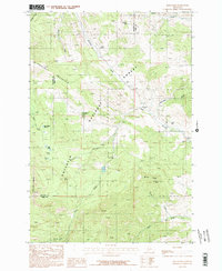 1987 Bald Knob1987 Print · USGSThe Gallatin Range in the late eighties reveals a landscape of industrial history and forest management on the Gallatin and Park county line. Researchers can trace the legacy of mountain extraction at the Kountz Mine and the Old Russell Mill or find the Trail Creek Guard Station.2 unique versions available
 - 1987 Map of Roundhead Butte
 1987 Roundhead Butte1987 Print · USGSThe Montana-Wyoming borderlands remained a pristine wilderness in the late eighties, where the northern boundary of Yellowstone National Park met the Gallatin National Forest. Researchers can trace remote alpine outposts like the Silver Tip Ranch, the Guard Station, and miles of Pack Trail winding through Slough Creek canyon.2 unique versions available
 - 1987 Map of Iron Mountain
 1987 Iron Mountain1987 Print · USGSPark County, Montana, at the height of the eighties backcountry mapping era reveals a high-altitude wilderness shaped by water. Researchers can trace the complex drainage of Hellroaring Creek and locate remote landmarks like Elk Lake and the Corral Footbridge.
 - 1987 Map of Monitor Peak
 1987 Monitor Peak1987 Print · USGSHigh in the Montana backcountry during the late eighties, this survey documents the protected landscapes of the Gallatin National Forest. Researchers can trace old routes via the Pack Trails to Monitor Peak or explore the headwaters of Placer Basin Creek.2 unique versions available
 - 1987 Map of Grassy Mountain
 1987 Grassy Mountain1987 Print · USGSGallatin and Park County are captured in the late 1980s, showing a high-country landscape primarily defined by the Gallatin National Forest. Researchers can trace primitive 4WD trails across Grassy Mountain and down to School Gulch Creek or Bishop Park.
 - 1987 Map of Chrome Mountain
 1987 Chrome Mountain1987 Print · USGSThe Boulder River corridor in southern Montana is shown in the late 1980s as a intersection of wilderness and mineral interest. Researchers can trace the remote infrastructure of the Gallatin National Forest, including the Chrome mine site, Flemming Bridge, and Camp-on-the-Boulder.
Showing maps 1-25 of 51
Top cities of Park County
Frequently asked questions
- What are the different types of historical maps available for Park County?
- What is the oldest map of Park County?
- Where can I purchase historical maps of Park County for my home or office?
- Where can I download high-res historical maps of Park County?
- Are there historical topographic maps available for Park County?
- Is there historical aerial imagery available for Park County?
- Where are historical maps of Park County sourced from?