Old Maps of Park County, Montana for Metal Detecting
Plan your next treasure hunt with 558 historic maps of Park County. Find old homesites, ghost towns, trails, and gathering spots that may be lost to time — perfect for identifying promising metal detecting locations.
- Locate forgotten sites: Uncover places like long-lost settlements, abandoned rail lines, or gathering spots.
- Plan better hunts: Use map overlays combined with LiDAR or satellite views to narrow in on historically rich areas.
- Made for detectorists: Thousands of hobbyists use these maps to discover relics, coins, and hidden history.
Use these historic maps to boost your research and find new opportunities beneath the surface of Park County.
Park County, MT maps
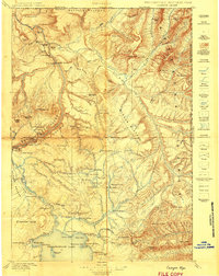
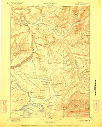
(558)- 1885 Map of Gallatin
 1885 Gallatin1885 Print · USGSNorthwestern Yellowstone in the 1880s remains a wild expanse of thermal basins and high peaks just as early visitors were beginning to arrive. Geologists and historians can trace the early footprint of Mammoth Hot Springs, the Norris Geyser Basin, and landmarks like Obsidian Cliff.
 - 1885 Map of Gallatin, 1886 Print
 1885 Gallatin1886 Print · USGSEarly park visitors and naturalists can trace the frontier-era geothermal landscape as it was first recorded in the mid-1880s. Identify original landmarks like the Hotel at Mammoth Hot Springs and the early topography of Norris Geyser Basin or Obsidian Cliff.2 unique versions available
 - 1886 Map of Canyon
 1886 Canyon1886 Print · USGSThe Grand Canyon of the Yellowstone area appears here in the late nineteenth century, just over a decade after the park's founding. Modern researchers can locate early landmarks like Yanceys, the Baronette Bridge, and the site of the Fossil Forest.
 - 1886 Map of Little Belt Mts.
 1886 Little Belt Mts.1886 Print · USGSCentral Montana territory during the mid-1880s is captured here, showing the region's early mining camps and ranching hubs. Researchers can trace the early layouts of White Sulphur Spring and Neihart or locate landmarks like Copperopolis and Crazy Peak.
 - 1888 Map of Three Forks
 1888 Three Forks1888 Print · USGSSouthwestern Montana was a land of mining camps and river junctions in the late nineteenth century, as the railroad began to connect established valleys. Genealogists can trace family roots through pioneer settlements like Virginia City, Salesville, and Spring Hill, or locate early crossings at Barton's Bridge.
 - 1891 Map of Livingston
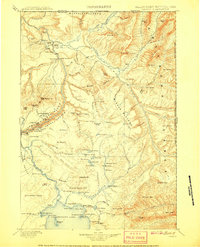
 1891 Livingston1891 Print · USGSUpper Yellowstone River country is documented here in the late nineteenth century as the railroad transformed the valley. Genealogists and historians can trace rail-stop towns like Cokedale, the military grounds at Ft. Ellis, and the Old Crow Agency.
 - 1893 Map of Livingston
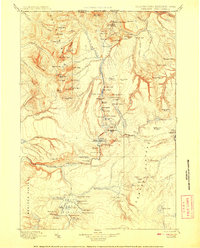
 1893 Livingston1893 Print · USGSThe Montana mountain country and the gateway to the national park are captured here in the late nineteenth century. Trace the industrial rail corridor through Livingston to mining sites like Coke and the historic Old Crow Agency.5 unique versions available
 - 1894 Map of Three Forks
 1894 Three Forks1894 Print · USGSSouthwestern Montana thrives along the river forks and rail lines during the mid-1880s. Genealogists and historians can trace early town sites like Pony, Logan, and Salesville while locating river crossings such as Fly's Bridge and Shedds Bridge.
 - 1894 Map of Little Belt Mts.
 1894 Little Belt Mts.1894 Print · USGSCentral Montana in the late nineteenth century is a land of emerging mining camps and river valley outposts. Historians can trace the early footprints of White Sulphur Spring, the copper prospects at Copperopolis, and the mountain terrain of Neihart.2 unique versions available
 - 1895 Map of Three Forks
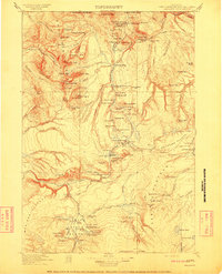
 1895 Three Forks1895 Print · USGSSouthern Montana was a landscape of emerging rail towns and gold-country gulches during the mid-1890s. Genealogists and historians can trace the early footprints of Bozeman, locate Guns Ranch, and follow the Northern Pacific Railroad through Three Forks.5 unique versions available
 - 1895 Map of Canyon
 1895 Canyon1895 Print · USGSYellowstone's early park architecture and geothermal wonders are captured here in the late nineteenth century. Trace early routes past the Baronett Bridge, the Hotel on the lake, and the storied settlement at Yanceys.
 - 1896 Map of Canyon
 1896 Canyon1896 Print · USGSYellowstone National Park is documented in the mid-1890s, capturing the early landmarks and hydrothermal features of the canyon country. Trace the early outposts at Yanceys or the Hotel and locate thermal sites like Calcite Springs and the Fossil Forest.2 unique versions available
 - 1897 Map of Little Belt Mts.
 1897 Little Belt Mts.1897 Print · USGSMeagher County and the central Montana high country are captured here in the 1890s, when mining camps and early ranching outposts were first being established. Researchers can trace the early layout of White Sulphur Springs and locate now-quiet sites like the Sapphire Mine or Copperopolis.
 - 1898 Map of Granite Mountain District
 1898 Granite Mountain District1898 Print · USGSThe Beartooth Range appears here in the late nineteenth century during a specialized survey for regional coal and electric companies. Researchers can trace early mountain pathways through Goose Lake Pass and locate major summits like Granite Peak and Mt Dewey.
 - 1898 Map of Little Belt Mts.
 1898 Little Belt Mts.1898 Print · USGSCentral Montana in the late nineteenth century is a landscape of mountain mining camps and early ranching outposts. Genealogists and historians can trace the pioneer footprints of White Sulphur Springs, the operations at Sapphire Mine, and the route of Sixteenmile Creek.
 - 1901 Map of Canyon
 1901 Canyon1901 Print · USGSYellowstone's northeast wilderness appears at the dawn of the twentieth century, detailing the park's early infrastructure and raw geothermal wonders. Researchers can trace the original locations of Yanceys, Baronett Bridge, and unique curiosities like the Fossil Forest.
 - 1901 Map of Gallatin
 1901 Gallatin1901 Print · USGSThe high plateau of the Yellowstone country appears here in the late nineteenth century, just as its hydrothermal wonders were becoming globally known. Researchers can locate early campsites and lodges near the Norris Geyser Basin, Obsidian Cliff, and Mammoth Hot Springs.
 - 1902 Map of Little Belt Mts.
 1902 Little Belt Mts.1902 Print · USGSMeagher County at the close of the nineteenth century is a landscape of mountain mining camps and riverside settlements. Researchers can trace early industry and family roots near the Sapphire Mine, the town of White Sulphur Springs, and the camp at Neihart.3 unique versions available
 - 1907 Map of Canyon
 1907 Canyon1907 Print · USGSYellowstone during the early years of the National Park Service era showcases a landscape defined by geothermal wonders and frontier outposts. Trace the early tourism routes past Yanceys and the Mushpots or locate historic features like Baronett Bridge.
 - 1908 Map of Gallatin
 1908 Gallatin1908 Print · USGSYellowstone National Park in the early 1900s reveals a wilderness of hydrothermal wonders and early frontier outposts. Trace the locations of original park structures like Fort Yellowstone and thermal landmarks including Norris Geyser Basin and Beryl Spring.
 - 1911 Map of Gallatin
 1911 Gallatin1911 Print · USGSYellowstone's thermal wonders and early military outposts are recorded in detail just after the turn of the century. Researchers can trace the early road and trail systems connecting landmark sites like Fort Yellowstone, the Norris Geyser Basin, and the Fountain Hotel.2 unique versions available
 - 1911 Map of Canyon
 1911 Canyon1911 Print · USGSYellowstone National Park is captured here in the early twentieth century as a fledgling wilderness preserve. Researchers can trace the early road system including the Cooke Road and find historic sites like Yanceys, the Canyon Hotel, and Fishing Bridge.6 unique versions available
 - 1940 Map of Mt. Cowen, 1958 Print
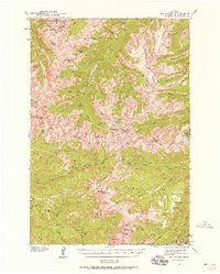 1940 Mt. Cowen1958 Print · USGSPark County's high mountain wilderness is captured here during the late Depression era, just before the war. Researchers can trace the early trail networks and backcountry landmarks like End Lookout, Beaver Meadows, and the peak of Mt Cowen.4 unique versions available
 - 1940 Map of Mt Wallace, 1963 Print
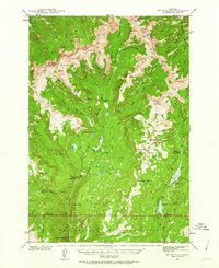 1940 Mt Wallace1963 Print · USGSPark County high country is documented here at the start of the 1940s, where national forest and park lands converge. Researchers can trace remote routes like the Poacher Trail and find isolated outposts such as Bull Moose Cabin and Hellroaring Ranger Station.3 unique versions available
 - 1941 Map of Mt Douglas, 1958 Print
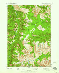 1941 Mt Douglas1958 Print · USGSHigh-altitude Montana ranching and resource extraction are captured here at the start of the 1940s. Genealogists and historians can trace early land use at Clydehurst Ranch, the Gish Mine, and the Fourmile Guard Station.4 unique versions available
Showing maps 1-25 of 558
Top cities of Park County
Frequently asked questions
- What are the different types of historical maps available for Park County?
- What is the oldest map of Park County?
- Where can I purchase historical maps of Park County for my home or office?
- Where can I download high-res historical maps of Park County?
- Are there historical topographic maps available for Park County?
- Is there historical aerial imagery available for Park County?
- Where are historical maps of Park County sourced from?