1900-1909 Maps of Park County, Montana
Explore 5 historic maps of Park County from 1900-1909. These maps offer a rare glimpse into what life looked like during the 1900s — showing old roads, neighborhoods, homes, and landmarks that have changed or disappeared over time.
Whether you're researching your family's past, planning a metal detecting trip, or studying how Park County's landscape evolved across the 1900s, these high-resolution maps are a powerful tool for exploring the history of this region.
- Focus on a specific era: All maps on this page are from the 1900s, giving you a focused view of this time period.
- See what’s changed: Compare century-old streets, trails, and buildings to today's modern landscape using overlays and satellite layers.
- Research with precision: Use these maps for genealogy, historical research, land use analysis, or educational projects.
- View, download, or print: Maps are fully viewable online in high resolution, and can be downloaded or printed for your own records.
Start exploring Park County's history through authentic maps from the 1900s. This is your window into the past.
Park County, MT maps
(5)- 1901 Map of Canyon
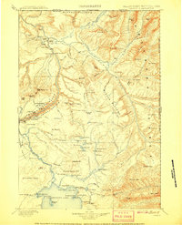
 1901 Canyon1901 Print · USGSYellowstone's northeast wilderness appears at the dawn of the twentieth century, detailing the park's early infrastructure and raw geothermal wonders. Researchers can trace the original locations of Yanceys, Baronett Bridge, and unique curiosities like the Fossil Forest.
 - 1901 Map of Gallatin
 1901 Gallatin1901 Print · USGSThe high plateau of the Yellowstone country appears here in the late nineteenth century, just as its hydrothermal wonders were becoming globally known. Researchers can locate early campsites and lodges near the Norris Geyser Basin, Obsidian Cliff, and Mammoth Hot Springs.
 - 1902 Map of Little Belt Mts.
 1902 Little Belt Mts.1902 Print · USGSMeagher County at the close of the nineteenth century is a landscape of mountain mining camps and riverside settlements. Researchers can trace early industry and family roots near the Sapphire Mine, the town of White Sulphur Springs, and the camp at Neihart.3 unique versions available
 - 1907 Map of Canyon
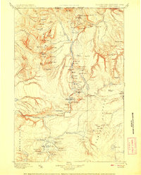
 1907 Canyon1907 Print · USGSYellowstone during the early years of the National Park Service era showcases a landscape defined by geothermal wonders and frontier outposts. Trace the early tourism routes past Yanceys and the Mushpots or locate historic features like Baronett Bridge.
 - 1908 Map of Gallatin
 1908 Gallatin1908 Print · USGSYellowstone National Park in the early 1900s reveals a wilderness of hydrothermal wonders and early frontier outposts. Trace the locations of original park structures like Fort Yellowstone and thermal landmarks including Norris Geyser Basin and Beryl Spring.
End of results
Showing maps 1-5 of 5
Top cities of Park County
Frequently asked questions
- What are the different types of historical maps available for Park County?
- What is the oldest map of Park County?
- Where can I purchase historical maps of Park County for my home or office?
- Where can I download high-res historical maps of Park County?
- Are there historical topographic maps available for Park County?
- Is there historical aerial imagery available for Park County?
- Where are historical maps of Park County sourced from?