1950s Maps of Park County, Montana
Explore 42 historic maps of Park County from the 1950s. These maps offer a rare glimpse into what life looked like during the 1950s — showing old roads, neighborhoods, homes, and landmarks that have changed or disappeared over time.
Whether you're researching your family's past, planning a metal detecting trip, or studying how Park County's landscape evolved across the 1950s, these high-resolution maps are a powerful tool for exploring the history of this region.
- Focus on a specific era: All maps on this page are from the 1950s, giving you a focused view of this time period.
- See what’s changed: Compare century-old streets, trails, and buildings to today's modern landscape using overlays and satellite layers.
- Research with precision: Use these maps for genealogy, historical research, land use analysis, or educational projects.
- View, download, or print: Maps are fully viewable online in high resolution, and can be downloaded or printed for your own records.
Start exploring Park County's history through authentic maps from the 1950s. This is your window into the past.
Park County, MT maps
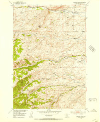
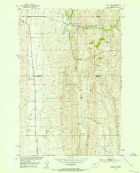
(42)- 1951 Map of Bozeman Pass, 1952 Print
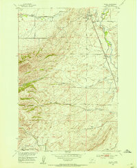
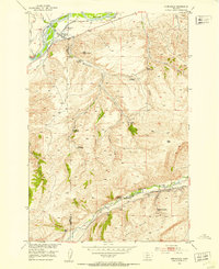
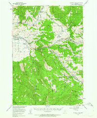 1951 Bozeman Pass1952 Print · USGSGallatin and Park counties are captured during the early 1950s, showing the high-country divide between Bozeman and Livingston. Genealogists and historians can trace family-named homesteads and old industrial sites like the Anaconda Copper Mines, Malmborg School, and the Shaodan Sawmill.5 unique versions available
 - 1951 Map of Ibex Mountain, 1952 Print
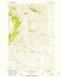
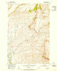
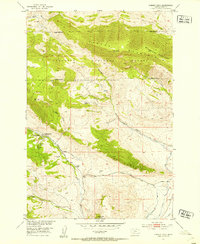
 1951 Ibex Mountain1952 Print · USGSPark County ranching culture is at its peak in the mid-century as this survey captures the intersection of the Crazy Mountains and high-country homesteads. Genealogists and local historians can trace the foundations of legacy properties like Footer Ranch or locate the old Cottonwood School and Rock Creek Cemetery.5 unique versions available
 - 1951 Map of Sixteen NE, 1952 Print
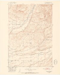
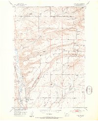
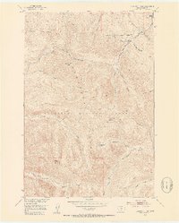
 1951 Sixteen NE1952 Print · USGSThe ranching country of central Montana is captured here just after mid-century as homesteads were consolidating. Genealogists and historians can trace family landmarks and land-use shifts through sites like Campbell Ranch, Heath Ranch, and the Oil Well on Elk Ridge.3 unique versions available
 - 1951 Map of Mount Rae, 1953 Print
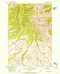
 1951 Mount Rae1953 Print · USGSHigh country ranching and early homesteading in Park County are documented here in the early fifties. Genealogists can trace family sites like the Rogers Homestead (Aban'd) or locate the Gordon School and West Boulder Ranger Station.6 unique versions available
 - 1951 Map of Gobblers Knob, 1953 Print
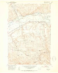
 1951 Gobblers Knob1953 Print · USGSThe high ranching country of the Missouri River Basin is captured here in the early fifties, showing the interplay between forest lands and family holdings. Researchers can locate specific homesteads like Hansen Ranch and Gibson Ranch or trace old mining activity at several mines (inactive) near Gobblers Knob.4 unique versions available
 - 1951 Map of Clyde Park, 1953 Print
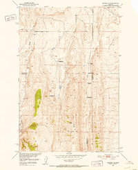
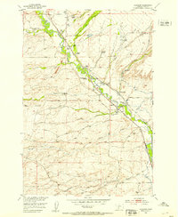
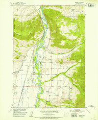
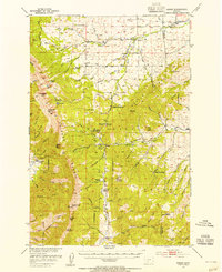
 1951 Clyde Park1953 Print · USGSThe ranching country of Park County comes into focus in the early 1950s, centered on the rail-side settlement of Clyde Park. Genealogists and historians can trace family holdings like the Thompson Ranch, locate the Sumner School, or follow the Northern Pacific tracks through the Shields River valley.3 unique versions available
 - 1951 Map of Wallrock, 1953 Print
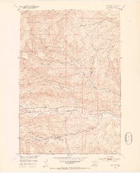
 1951 Wallrock1953 Print · USGSGallatin and Park counties in the early fifties reveal a high-country landscape at the headwaters of the Missouri River Basin. Researchers can trace the complex drainage of Wallrock Basin and locate the mountain-fed Kistner-Hardy Dam near Wallrock.3 unique versions available
 - 1951 Map of Chadborn, 1953 Print
 1951 Chadborn1953 Print · USGSThe Shields River valley was a thriving ranching corridor in the early fifties, where the railroad and river dictated the local economy. Researchers can trace numerous family homesteads like Schindler Ranch, locate the Cowan School, and follow the Northern Pacific line.4 unique versions available
 - 1951 Map of Wolf Hill, 1953 Print
 1951 Wolf Hill1953 Print · USGSThe high country of Park and Meagher Counties is captured here in the early fifties, showing a ranching landscape in transition. Genealogists and historians can locate legacy homesteads like Arthur Ranch alongside industrial remnants such as an Oil Well (Abnd) and Coal Mine (Abnd).2 unique versions available
 - 1951 Map of Grannis, 1953 Print
 1951 Grannis1953 Print · USGSPark County ranching country comes alive in this mid-century survey of the Shields River valley. Researchers can trace the heritage of local families at the Eyman and Bonhomme sites, or locate old educational landmarks like the Falls Creek School.4 unique versions available
 - 1951 Map of Brisbin, 1953 Print
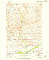
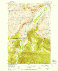
 1951 Brisbin1953 Print · USGSParadise Valley and the Yellowstone River are captured here in the early fifties, showing the vital rail and ranching corridor of Park County. Genealogists can trace family landmarks like Trowbridge Ranch, the Strickland Cem, and several local schools like Suce Creek School.5 unique versions available
 - 1951 Map of Hoppers, 1953 Print
 1951 Hoppers1953 Print · USGSPark County, Montana, at mid-century reveals a landscape transitioning from its coal-mining peak to a quiet mountain district. Genealogists and industrial historians can locate the ruins of Cokedale, including the Cokedale School, Coke Ovens, and the old railroad siding at Hoppers.5 unique versions available
 - 1951 Map of Wilsall, 1953 Print
 1951 Wilsall1953 Print · USGSIn the early 1950s, the Park County landscape centered on the Wilsall railhead and the fertile Shields River valley. Genealogists can locate the Wilsall Cemetery and rural landmarks like the Brackett Creek School and Meyersburg.3 unique versions available
 - 1951 Map of Kelly Hills, 1953 Print
 1951 Kelly Hills1953 Print · USGSRanching life along the Yellowstone River in the early fifties reveals a landscape of family-named spreads and irrigation networks. Genealogists and historians can trace local landmarks like the Old Kelly Homestead, Duck Creek School, and the Northern Pacific rail line.3 unique versions available
 - 1951 Map of Livingston Peak, 1953 Print
 1951 Livingston Peak1953 Print · USGSThe high Absaroka backcountry comes to life in this early 1950s survey, showing the transition from valley ranches to national forest peaks. Trace the early boundaries of the 63 Ranch or locate high-country landmarks like Livingston Peak and Blacktail Lake.5 unique versions available
 - 1951 Map of Chimney Rock, 1953 Print
 1951 Chimney Rock1953 Print · USGSPark County, Montana, is shown here in the early postwar era as a landscape of mining camps and high-country ranching. Genealogists and historians can trace the local legacy of the Maxey family through the Hoffman School and the nearby Maxey Mines.3 unique versions available
 - 1951 Map of Springdale, 1953 Print
 1951 Springdale1953 Print · USGSRanching and rail life converge along the Yellowstone River in the early 1950s as the Northern Pacific railroad services the valley. Researchers can trace family landholdings like the Hash Homestead and Mason Homestead near the Coal Mine Rim.4 unique versions available
 - 1951 Map of Mc Leod Basin, 1953 Print
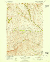
 1951 Mc Leod Basin1953 Print · USGSSweet Grass and Park counties in the early fifties show a transition between high-country wilderness and mountain ranching. You can locate early-century sites like the West Boulder School, the Old Kainuck Guest Ranch, and the Coal Mine along the river canyon.7 unique versions available
 - 1951 Map of Hunters Hot Springs, 1953 Print
 1951 Hunters Hot Springs1953 Print · USGSThe ranching country of Park and Sweet Grass counties is captured here in the early fifties, showing the evolution of the Missouri River Basin. Genealogists can trace family holdings and sites like the Roebacker Homestead, Martel Homestead, and Hunters Hot Springs.4 unique versions available
 - 1951 Map of Elton, 1953 Print
 1951 Elton1953 Print · USGSPark County ranching and rail history are well-preserved here in the early fifties, as the Yellowstone River corridor supported a series of large family holdings. Genealogists can trace a remarkable number of named sites, from the Locke Creek School to the Alkire Homestead and the settlement of Elton.5 unique versions available
 - 1951 Map of Fairview Peak, 1953 Print
 1951 Fairview Peak1953 Print · USGSThe Crazy Mountains in the early 1950s show a landscape of high-altitude drainage and transition. Researchers can trace the exact locations of several former mountain residences, including the Holland Homestead (Aban'd) and the Bishit Sawmill (Aban'd).4 unique versions available
 - 1951 Map of Livingston, 1953 Print
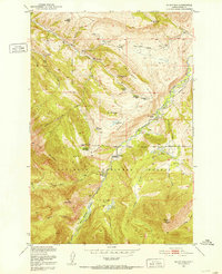
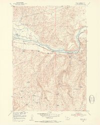
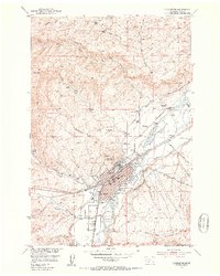 1951 Livingston1953 Print · USGSLivingston thrived as a bustling rail and ranching center in the early fifties, situated where the tracks met the river. Researchers can trace historic family holdings like the Loyd Uhl Ranch and local landmarks like Mountainview Cemetery or the Radio Tower (KPRK).7 unique versions available
 - 1951 Map of Sedan, 1956 Print
 1951 Sedan1956 Print · USGSThe high country of the Bridger Range and the settlement of Sedan are shown in the early fifties, highlighting a landscape of timber and ranching. Researchers can locate the Ryan Sawmill, the historic Spring Hill Pavilion, and remote outposts like Battle Ridge Ranger Station.3 unique versions available
 - 1952 Map of Mission, 1953 Print
 1952 Mission1953 Print · USGSThe Yellowstone River valley is captured here in the early fifties, featuring the confluence with the Shields River and the growing aviation infrastructure. Researchers can locate numerous family holdings like Windsor Ranch and Mission Ranch, plus the site of the Sunset County Farm.4 unique versions available
 - 1954 Map of Billings, 1963 Print
 1954 Billings1963 Print · USGSThe Yellowstone valley during the mid-fifties shows a landscape of thriving rail towns and high-mountain outposts. Genealogists and historians can trace old homesteads and mining routes near Red Lodge, Bearcreek, and along the Bighorn River.4 unique versions available
Showing maps 1-25 of 42
Top cities of Park County
Frequently asked questions
- What are the different types of historical maps available for Park County?
- What is the oldest map of Park County?
- Where can I purchase historical maps of Park County for my home or office?
- Where can I download high-res historical maps of Park County?
- Are there historical topographic maps available for Park County?
- Is there historical aerial imagery available for Park County?
- Where are historical maps of Park County sourced from?