1950s Maps of Teton County, Montana
Explore 28 historic maps of Teton County from the 1950s. These maps offer a rare glimpse into what life looked like during the 1950s — showing old roads, neighborhoods, homes, and landmarks that have changed or disappeared over time.
Whether you're researching your family's past, planning a metal detecting trip, or studying how Teton County's landscape evolved across the 1950s, these high-resolution maps are a powerful tool for exploring the history of this region.
- Focus on a specific era: All maps on this page are from the 1950s, giving you a focused view of this time period.
- See what’s changed: Compare century-old streets, trails, and buildings to today's modern landscape using overlays and satellite layers.
- Research with precision: Use these maps for genealogy, historical research, land use analysis, or educational projects.
- View, download, or print: Maps are fully viewable online in high resolution, and can be downloaded or printed for your own records.
Start exploring Teton County's history through authentic maps from the 1950s. This is your window into the past.
Teton County, MT maps
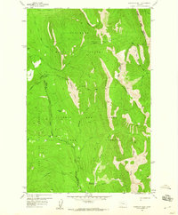
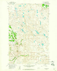
(28)- 1950 Map of Timber Coulee
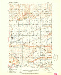
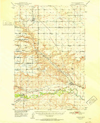
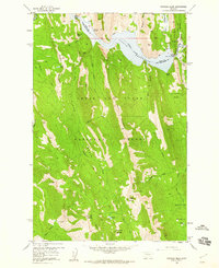
 1950 Timber Coulee1950 Print · USGSMontana's high prairie and river breaks are documented here in the mid-1940s, showing a landscape defined by the winding Teton River. Genealogists and local historians can trace the locations of the Knee Church, the Jensen Elevator, and early rural schools like Promised Land School.
 - 1950 Map of Fairfield, 1952 Print
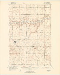
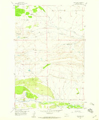
 1950 Fairfield1952 Print · USGSIn the early 1950s, the Teton County prairie was a landscape of irrigation canals and rail lines centered on Fairfield. Trace the development of the Missouri River Basin through features like the Greenfield Main Canal, Old Fort Shaw, and the Great Northern railroad.4 unique versions available
 - 1950 Map of Dutton, 1952 Print
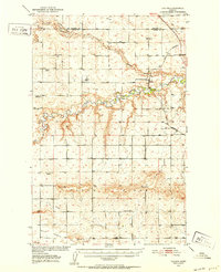
 1950 Dutton1952 Print · USGSDutton and the surrounding Teton County plains are shown in the early 1950s as a thriving rail-side agricultural community. Genealogists can trace a network of rural schoolhouses like Doheney School and Pleasant School, alongside the Great Northern railroad line.3 unique versions available
 - 1950 Map of Collins, 1952 Print
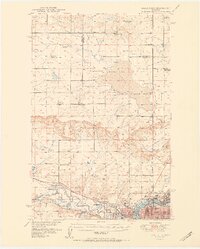
 1950 Collins1952 Print · USGSTeton County and Pondera County meet along the meanders of the Teton River at the height of the post-war ranching and rail era. Researchers can trace the rural school network including South Liberty Sch, or locate family landmarks like Beck Cem and the grain hub at Zim Elevator.2 unique versions available
 - 1951 Map of Great Falls
 1951 Great Falls1951 Print · USGSGreat Falls and the surrounding Cascade County plains come alive in this mid-century survey of the Missouri River basin. Genealogists and local historians can trace the early layout of Black Eagle, locate the Ursuline Academy, and follow the historic Bootlegger Trail.2 unique versions available
 - 1952 Map of Vaughn
 1952 Vaughn1952 Print · USGSThe Montana benchlands north of Great Falls come into focus in the early fifties, where the Sun River and Muddy Creek meet. Genealogists and historians can trace the irrigation canals, the Great Northern rail lines, and landmarks like Sun River Cemetery or the Gettel School.
 - 1954 Map of Great Falls
 1954 Great Falls1954 Print · USGSThe Missouri River valley in the mid-1950s is shown at a time of significant industrial and military growth. Genealogists and historians can locate early schools and rail stops like Tiger Butte Community Center, Fort Benton, and the Anaconda Wire Plant.4 unique versions available
 - 1954 Map of Shelby, 1967 Print
 1954 Shelby1967 Print · USGSNorthern Montana's Hi-Line is captured in the mid-fifties, showing a landscape shaped by the Great Northern rail and early oil development. Trace family roots in Shelby and Conrad, or locate rural landmarks like Goose Bill Butte and the Rocky Boys Indian Reservation.3 unique versions available
 - 1955 Map of Choteau, 1978 Print
 1955 Choteau1978 Print · USGSWestern Montana during the mid-fifties is captured here as a land of rugged high-country wilderness and vital eastern plains irrigation. Genealogists and historians can locate remote outposts like Condon, the communal Miller Colony, and the rail stops of the Chicago Milwaukee St Paul and Pacific.
 - 1957 Map of Choteau
 1957 Choteau1957 Print · USGSMontana's mountain front meets the eastern plains in the mid-fifties, showing the transition from forested wilderness to irrigated ranch land. Genealogists and historians can trace the rail lines of the Great Northern and find settlements like Choteau, Augusta, and Seeley Lake.
 - 1957 Map of Great Falls
 1957 Great Falls1957 Print · USGSMontana's central plains and mountain foothills are captured here in the mid-fifties, showing the hub of Great Falls and the surrounding grain-shipping towns. Genealogists can trace family roots through the rail sidings of the Great Northern and small rural communities like Sand Coulee or Fort Benton.
 - 1958 Map of Shelby
 1958 Shelby1958 Print · USGSNorthern Montana’s high plains and the Sweetgrass Hills come to life in the late fifties as the Tiber Dam begins to reshape the Marias River valley. Genealogists and historians can trace rail-town lineages along the Great Northern line and locate sites like the Hull Coal Mine or Sweet Grass.
 - 1958 Map of Choteau
 1958 Choteau1958 Print · USGSMontana's front range meets the high wilderness in the late fifties, where the Great Northern railway connects ranching towns to the eastern plains. Researchers can trace the development of irrigation at Bynum Reservoir or locate remote camps like the Big Prairie District Ranger Station and Helmville.2 unique versions available
 - 1958 Map of Ear Mountain, 1959 Print
 1958 Ear Mountain1959 Print · USGSThe Montana Front meets the plains in the late fifties, showcasing a wilderness of forest outposts and high-altitude gulches. Trace early access routes to Ear Mountain Ranger Station and Gleason Resort along the Teton River.2 unique versions available
 - 1958 Map of Lake Theboe, 1959 Print
 1958 Lake Theboe1959 Print · USGSTeton County ranching culture is well-documented in the late fifties, showing a landscape shaped by family estates and scattered rural infrastructure. Researchers can trace the footprint of the Saypo (Site) and find landmarks like Bellview Sch or Lake Theboe.2 unique versions available
 - 1958 Map of Cave Mountain, 1959 Print
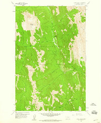
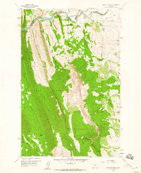
 1958 Cave Mountain1959 Print · USGSTeton County ranching and mountain wilderness meet in the late fifties as the Front Range transitions into the Montana plains. Genealogists and historians can locate legacy landholdings like the Burfening Ranch or trace the remote pack trails near Cave Mountain.3 unique versions available
 - 1958 Map of Porphyry Reef, 1959 Print
 1958 Porphyry Reef1959 Print · USGSThe Montana high country along the Continental Divide is shown here in the late fifties, where the Flathead Range meets the Sun River headwaters. Trace the remote Pack Trail network connecting the Wrong Creek Guard Station to landmarks like Porphyry Reef and Teton Pass.2 unique versions available
 - 1958 Map of Mount Wright, 1959 Print
 1958 Mount Wright1959 Print · USGSIn the Teton range during the late fifties, this survey captures a landscape of remote ranger outposts and high-altitude drainage systems. Researchers can trace the backcountry network through the West Fork Ranger Station, the Empty Jug Cabin, and an extensive Pack Trail.3 unique versions available
 - 1958 Map of Twin Lakes, 1959 Print
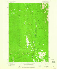
 1958 Twin Lakes1959 Print · USGSTeton County ranchlands in the late fifties are defined here by a network of isolated homesteads and winding creek beds. Genealogists can trace family holdings like Hughes Ranch and Knowlton Ranch or locate the rural Blackleaf Sch.2 unique versions available
 - 1958 Map of Our Lake, 1959 Print
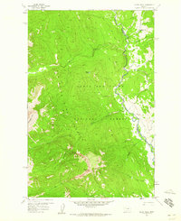
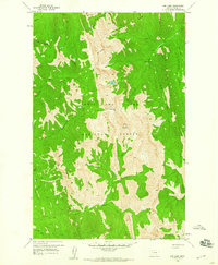 1958 Our Lake1959 Print · USGSTeton County's high wilderness in the late fifties is captured here at the crest of the Rockies before modern development. Trace the primitive Pack Trail networks connecting isolated landmarks like Beartop Lookout, Our Lake, and Rocky Mountain.3 unique versions available
 - 1958 Map of Barr Creek, 1960 Print
 1958 Barr Creek1960 Print · USGSThe Sun River country comes into focus in the late fifties, showing a landscape defined by ranching and water engineering. Researchers can trace early irrigation routes like Geldrich Ditch and find local landmarks such as Morris Ranch and Black Butte.2 unique versions available
 - 1958 Map of Sawtooth Ridge, 1960 Print
 1958 Sawtooth Ridge1960 Print · USGSIn the late 1950s, this Montana wilderness was a landscape of high alpine ridges and early water infrastructure. You can trace early forest management and remote outposts from the Sun Canyon Lodge to the Hannan Gulch Guard Sta and Home Pack Trail.4 unique versions available
 - 1958 Map of Glenn Creek, 1960 Print
 1958 Glenn Creek1960 Print · USGSThe Lewis and Clark National Forest in the late 1950s is revealed as a landscape of high summits and winding river forks. Track the remote Cabin Creek Guard Station, the crossing at Cabin Bridge, and the reach of the Sun River Game Preserve Bdy.4 unique versions available
 - 1958 Map of Gates Park, 1960 Print
 1958 Gates Park1960 Print · USGSThe Sun River backcountry in the late fifties was a vital hub for forest management and wilderness navigation. Researchers can trace the remote Gates Park Guard Station, its isolated Landing Strip, and the Pack Trail routes near Rabbit Butte.3 unique versions available
 - 1958 Map of Patricks Basin, 1960 Print
 1958 Patricks Basin1960 Print · USGSIn the late 1950s, this area of the Lewis and Clark National Forest centered on the water management of Gibson Reservoir and high-country ranching. Trace the path of the Pack Trail past Klick Lower Ranch or locate the remote Sheep Sheds.3 unique versions available
Showing maps 1-25 of 28
Top cities of Teton County
Frequently asked questions
- What are the different types of historical maps available for Teton County?
- What is the oldest map of Teton County?
- Where can I purchase historical maps of Teton County for my home or office?
- Where can I download high-res historical maps of Teton County?
- Are there historical topographic maps available for Teton County?
- Is there historical aerial imagery available for Teton County?
- Where are historical maps of Teton County sourced from?