1920s Maps of Toole County, Montana
Explore 2 historic maps of Toole County from the 1920s. These maps offer a rare glimpse into what life looked like during the 1920s — showing old roads, neighborhoods, homes, and landmarks that have changed or disappeared over time.
Whether you're researching your family's past, planning a metal detecting trip, or studying how Toole County's landscape evolved across the 1920s, these high-resolution maps are a powerful tool for exploring the history of this region.
- Focus on a specific era: All maps on this page are from the 1920s, giving you a focused view of this time period.
- See what’s changed: Compare century-old streets, trails, and buildings to today's modern landscape using overlays and satellite layers.
- Research with precision: Use these maps for genealogy, historical research, land use analysis, or educational projects.
- View, download, or print: Maps are fully viewable online in high resolution, and can be downloaded or printed for your own records.
Start exploring Toole County's history through authentic maps from the 1920s. This is your window into the past.
Toole County, MT maps
(2)- 1920 Map of Dupuyer
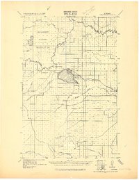 1920 Dupuyer1920 Print · USGSHigh plains ranching and early irrigation projects define this 1920s survey of the Montana frontier. Genealogists and historians can trace the early rail stops and homestead hubs at Valier, Pendroy, and Manson along the Montana Western R. R. line.
 - 1920 Map of Conrad
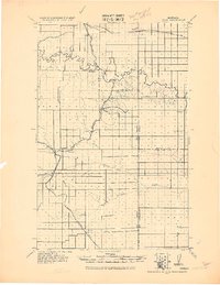 1920 Conrad1920 Print · USGSNorthern Montana plains at the height of the homesteading era are captured here during a period of rapid rail-led growth. Researchers can trace early postal locations like Omholt P. O. and the junction of the Great Northern R. R. in towns like Conrad and Brady.
End of results
Showing maps 1-2 of 2
Top cities of Toole County
Frequently asked questions
- What are the different types of historical maps available for Toole County?
- What is the oldest map of Toole County?
- Where can I purchase historical maps of Toole County for my home or office?
- Where can I download high-res historical maps of Toole County?
- Are there historical topographic maps available for Toole County?
- Is there historical aerial imagery available for Toole County?
- Where are historical maps of Toole County sourced from?