1950s Maps of Valley County, Montana
Explore 21 historic maps of Valley County from the 1950s. These maps offer a rare glimpse into what life looked like during the 1950s — showing old roads, neighborhoods, homes, and landmarks that have changed or disappeared over time.
Whether you're researching your family's past, planning a metal detecting trip, or studying how Valley County's landscape evolved across the 1950s, these high-resolution maps are a powerful tool for exploring the history of this region.
- Focus on a specific era: All maps on this page are from the 1950s, giving you a focused view of this time period.
- See what’s changed: Compare century-old streets, trails, and buildings to today's modern landscape using overlays and satellite layers.
- Research with precision: Use these maps for genealogy, historical research, land use analysis, or educational projects.
- View, download, or print: Maps are fully viewable online in high resolution, and can be downloaded or printed for your own records.
Start exploring Valley County's history through authentic maps from the 1950s. This is your window into the past.
Valley County, MT maps
(21)- 1954 Map of Jordan, 1965 Print
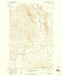
 1954 Jordan1965 Print · USGSGarfield County in the mid-fifties is a land of expansive ranches and isolated prairie schoolhouses. Researchers can trace rural genealogy and land use through landmarks like Regina School, Robertson Brothers Ranch, and the Charles M Russell National Wildlife Range.2 unique versions available
 - 1954 Map of Wolf Point, 1967 Print
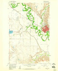
 1954 Wolf Point1967 Print · USGSNortheastern Montana and the North Dakota borderlands are shown here in the mid-fifties, dominated by the Missouri River and the Fort Peck Indian Reservation. Genealogists and historians can trace the Great Northern rail line through river towns like Poplar and Culbertson or locate northern border outposts like the U S Custom Office at Raymond.2 unique versions available
 - 1954 Map of Glasgow, 1967 Print
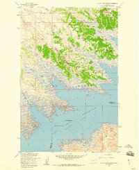
 1954 Glasgow1967 Print · USGSNortheastern Montana is shown during the mid-fifties as the rail-and-river economy shaped the plains. Trace family roots and vanished landmarks from the Wendell Post Office to the Great Northern sidings at Ashfield and Hinsdale.2 unique versions available
 - 1956 Map of Jordan
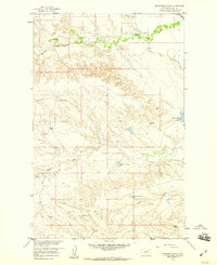
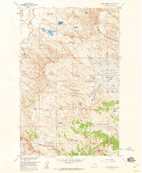
 1956 Jordan1956 Print · USGSCentral Montana ranching country and the massive Missouri River impoundment are captured here in the mid-fifties. Researchers can trace remote homesteading landmarks like Robertson Brothers Ranch and small rural hubs including Jordan, Brusett, and Cohagen.
 - 1957 Map of Glasgow
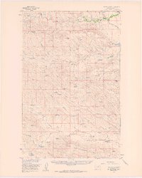
 1957 Glasgow1957 Print · USGSNortheastern Montana during the late 1950s shows a landscape shaped by the Milk River and the expanding influence of the Fort Peck Lake reservoir. Genealogists and historians can trace the Great Northern rail stops from Malta to Glasgow, including old sidings like Kintyre Siding and rural centers like Opheim.
 - 1958 Map of Wolf Point
 1958 Wolf Point1958 Print · USGSNortheastern Montana is shown during the mid-fifties, featuring the extensive Fort Peck Indian Reservation and the Missouri River valley. Researchers can trace the Great Northern railroad through Wolf Point or locate sites like Slab Crossing and the Coal Mine near Medicine Lake.
 - 1958 Map of Glasgow
 1958 Glasgow1958 Print · USGSNortheastern Montana comes to life in this mid-century survey of the Milk River valley and the Great Northern rail corridor. Researchers can trace the rise and fall of work camps like New Deal and Wheeler alongside remote landmarks like the Wendell Post Office.2 unique versions available
 - 1958 Map of Jordan
 1958 Jordan1958 Print · USGSGarfield County and the Missouri River country are shown here in the late fifties as the regional geography adjusted to the massive new reservoir. Genealogists and local historians can trace isolated homesteads and numerous rural schoolhouses like Iler School, Brusett, and the Robertson Brothers Ranch.
 - 1958 Map of Engstrom Ranch, 1960 Print
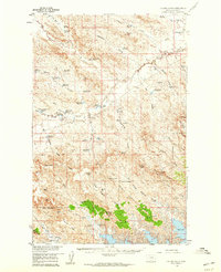
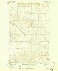
 1958 Engstrom Ranch1960 Print · USGSValley County ranching life is captured here in the late fifties, showcasing the remote homesteads and water infrastructure of northern Montana. Genealogists and historians can locate family landmarks like Engstrom Ranch, Uphaus Ranch, and the Vandalia South Canal.2 unique versions available
 - 1958 Map of Miller Coulee, 1960 Print
 1958 Miller Coulee1960 Print · USGSValley County ranching life is preserved in this late-fifties survey of the high plains. Genealogists and historians can trace family-named landmarks like Billingsley Ranch, Blanchard Cabin, and the intricate water system of Two Butte Reservoir.
 - 1958 Map of Collins Ranch, 1960 Print
 1958 Collins Ranch1960 Print · USGSMontana's high plains ranching culture is preserved here in the late fifties, showing a landscape defined by water management and isolated homesteads. Researchers can trace the heritage of local families at Collins Ranch, Magruder Ranch, and the lonely height of Graveyard Hill.2 unique versions available
 - 1958 Map of Maloney Hill, 1960 Print
 1958 Maloney Hill1960 Print · USGSGarfield County, Montana, is depicted in the late fifties as the Missouri River Basin development transformed the landscape. You can trace the intricate shoreline of the Fort Peck Reservoir and locate landmarks like Peterson Point, Maloney Hill, and the Hell Creek Recreation Area.2 unique versions available
 - 1958 Map of Lewis Reservoir, 1960 Print
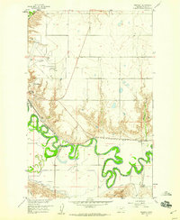
 1958 Lewis Reservoir1960 Print · USGSValley County, Montana, is captured here in the late fifties as federal land and water management projects reshaped the Missouri River Basin. You can trace the intricate network of coulees and early catchments like Lost McMenomey Reservoir and the Rentention Levees Experimental Area.3 unique versions available
 - 1958 Map of Sage Creek Point, 1960 Print
 1958 Sage Creek Point1960 Print · USGSGarfield County, Montana, is captured during the late 1950s as the Fort Peck Reservoir transformed the Missouri River valley. Genealogists and local historians can locate the Cemetery near Sage Creek Point and trace the complex network of Embleton Coulee.2 unique versions available
 - 1958 Map of Glasgow, 1960 Print
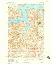
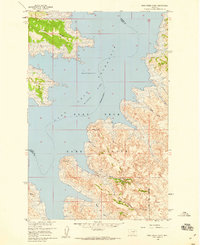
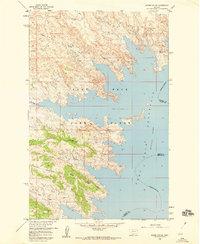
 1958 Glasgow1960 Print · USGSGlasgow and its surrounding river valley are shown here in the late fifties as a bustling regional hub along the Great Northern rail line. Researchers can trace the town's social fabric through landmarks like the St Raphael Sch, the Deaconess Hospital, and the outlying settlement of Paisley.3 unique versions available
 - 1958 Map of Blanchard Ranch, 1960 Print
 1958 Blanchard Ranch1960 Print · USGSValley County ranching and water management come into focus in the late fifties. Researchers can trace land use through family-named sites like Blanchard Ranch, the Retention Levees Experimental Area, and Jack Rabbit Reservoir.2 unique versions available
 - 1958 Map of Seventh Point Buttes, 1960 Print
 1958 Seventh Point Buttes1960 Print · USGSThe Missouri River breaks of Montana are captured here during the late fifties, showcasing the complex shoreline of the Fort Peck Reservoir. Trace the rugged topography of the Fort Peck Game Range and locate landmarks like Seventh Point Buttes and The Pines Recreation Area.2 unique versions available
 - 1958 Map of Wheeler, 1960 Print
 1958 Wheeler1960 Print · USGSValley County, Montana, is captured in the late fifties as a landscape of deep coulees and wide grazing lands near the Missouri River. Genealogists and local historians can locate the Newton Sch and the settlement of Wheeler, or trace the winding paths of Dogie Creek and Galpin Coulee.2 unique versions available
 - 1958 Map of Whately, 1960 Print
 1958 Whately1960 Print · USGSIn the late 1950s, the Valley County landscape was defined by the winding Milk River and the vital Great Northern rail line. Genealogists and historians can locate Whately, trace the Vandalia South Canal, or find the Glasgow Highland Cem.3 unique versions available
 - 1958 Map of Billick Coulee, 1960 Print
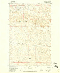 1958 Billick Coulee1960 Print · USGSValley County ranchlands in the late fifties are defined by the winding drainages of Billick Coulee and Brazil Creek. Researchers can trace old livestock water sites like Wagon Top Reservoir and early backcountry routes via the northern Jeep Trail.2 unique versions available
 - 1958 Map of Skunk Coulee, 1960 Print
 1958 Skunk Coulee1960 Print · USGSThe Montana shoreline of Valley and Garfield Counties is captured here in the late fifties as the Missouri River Basin project transformed the landscape. Researchers can trace the mid-century water levels of the Fort Peck Reservoir and explore landmarks like Skunk Coulee and the Fort Peck Game Range.
End of results
Showing maps 1-21 of 21
Top cities of Valley County
Frequently asked questions
- What are the different types of historical maps available for Valley County?
- What is the oldest map of Valley County?
- Where can I purchase historical maps of Valley County for my home or office?
- Where can I download high-res historical maps of Valley County?
- Are there historical topographic maps available for Valley County?
- Is there historical aerial imagery available for Valley County?
- Where are historical maps of Valley County sourced from?