1960s Maps of Chase County, Nebraska
Explore 4 historic maps of Chase County from the 1960s. These maps offer a rare glimpse into what life looked like during the 1960s — showing old roads, neighborhoods, homes, and landmarks that have changed or disappeared over time.
Whether you're researching your family's past, planning a metal detecting trip, or studying how Chase County's landscape evolved across the 1960s, these high-resolution maps are a powerful tool for exploring the history of this region.
- Focus on a specific era: All maps on this page are from the 1960s, giving you a focused view of this time period.
- See what’s changed: Compare century-old streets, trails, and buildings to today's modern landscape using overlays and satellite layers.
- Research with precision: Use these maps for genealogy, historical research, land use analysis, or educational projects.
- View, download, or print: Maps are fully viewable online in high resolution, and can be downloaded or printed for your own records.
Start exploring Chase County's history through authentic maps from the 1960s. This is your window into the past.
Chase County, NE maps
(4)- 1961 Map of Lamar NE, 1963 Print
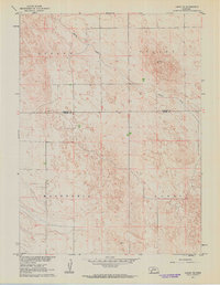 1961 Lamar NE1963 Print · USGSWestern Nebraska ranching country and the high plains are detailed here in the early sixties. Researchers can trace land holdings and fence lines between Stephenson and McCoy, or follow the winding course of Spring Creek through Lisbon Valley.
 - 1961 Map of Lamar, 1963 Print
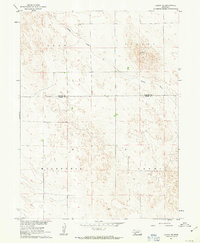 1961 Lamar1963 Print · USGSThe High Plains on the Perkins and Chase County line appear here in the early sixties, showing a landscape of remote ranching and prairie drainage. Researchers can trace the rural communities of Stephenson and McCoy or follow the path of Spring Creek.
 - 1961 Map of Lamar NW, 1963 Print
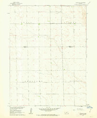 1961 Lamar NW1963 Print · USGSThe high plains along the Perkins and Chase County line are captured here in the early sixties, showing a landscape defined by organized agricultural tracts. Genealogists and historians can locate Greenfield Ch and the distinct boundaries of Grace and Macedonia.2 unique versions available
 - 1962 Map of Amherst NE, 1964 Print
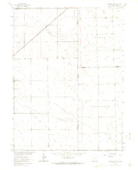 1962 Amherst NE1964 Print · USGSHigh plains ranching and rail transport define this interstate borderland during the early sixties. Researchers can trace the Chicago Burlington and Quincy rail line and locate the Venango Cem near the Colorado Nebraska line.3 unique versions available
End of results
Showing maps 1-4 of 4
Top cities of Chase County
Frequently asked questions
- What are the different types of historical maps available for Chase County?
- What is the oldest map of Chase County?
- Where can I purchase historical maps of Chase County for my home or office?
- Where can I download high-res historical maps of Chase County?
- Are there historical topographic maps available for Chase County?
- Is there historical aerial imagery available for Chase County?
- Where are historical maps of Chase County sourced from?