1980s Maps of Chase County, Nebraska
Explore 3 historic maps of Chase County from the 1980s. These maps offer a rare glimpse into what life looked like during the 1980s — showing old roads, neighborhoods, homes, and landmarks that have changed or disappeared over time.
Whether you're researching your family's past, planning a metal detecting trip, or studying how Chase County's landscape evolved across the 1980s, these high-resolution maps are a powerful tool for exploring the history of this region.
- Focus on a specific era: All maps on this page are from the 1980s, giving you a focused view of this time period.
- See what’s changed: Compare century-old streets, trails, and buildings to today's modern landscape using overlays and satellite layers.
- Research with precision: Use these maps for genealogy, historical research, land use analysis, or educational projects.
- View, download, or print: Maps are fully viewable online in high resolution, and can be downloaded or printed for your own records.
Start exploring Chase County's history through authentic maps from the 1980s. This is your window into the past.
Chase County, NE maps
(3)- 1981 Map of Wray, 1982 Print
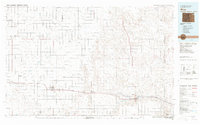 1981 Wray1982 Print · USGSThe high plains at the meeting of Colorado, Nebraska, and Kansas are documented here in the early 1980s. Local researchers can trace the Burlington Northern rail corridor and locate rural landmarks like Lone Star, Glocken Hill, and Dearing Lake.
 - 1982 Map of Lambs Lake NE
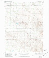 1982 Lambs Lake NE1982 Print · USGSHolt County, Nebraska, is shown in the early eighties as a landscape of remote ranching outposts and essential water sources. Genealogists can trace rural family life through the locations of School No 169 and School No 77 near Holt Creek.
 - 1983 Map of Julesburg
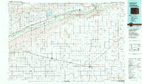 1983 Julesburg1983 Print · USGSNortheastern Colorado and the Nebraska borderlands are captured here in the early eighties, centered on the vital South Platte River valley. Researchers can trace the path of the Union Pacific through towns like Julesburg or explore the rural layout of Peetz Table.
End of results
Showing maps 1-3 of 3
Top cities of Chase County
Frequently asked questions
- What are the different types of historical maps available for Chase County?
- What is the oldest map of Chase County?
- Where can I purchase historical maps of Chase County for my home or office?
- Where can I download high-res historical maps of Chase County?
- Are there historical topographic maps available for Chase County?
- Is there historical aerial imagery available for Chase County?
- Where are historical maps of Chase County sourced from?