2020s Maps of Dawes County, Nebraska
Explore 44 historic maps of Dawes County from the 2020s. These maps offer a rare glimpse into what life looked like during the 2020s — showing old roads, neighborhoods, homes, and landmarks that have changed or disappeared over time.
Whether you're researching your family's past, planning a metal detecting trip, or studying how Dawes County's landscape evolved across the 2020s, these high-resolution maps are a powerful tool for exploring the history of this region.
- Focus on a specific era: All maps on this page are from the 2020s, giving you a focused view of this time period.
- See what’s changed: Compare century-old streets, trails, and buildings to today's modern landscape using overlays and satellite layers.
- Research with precision: Use these maps for genealogy, historical research, land use analysis, or educational projects.
- View, download, or print: Maps are fully viewable online in high resolution, and can be downloaded or printed for your own records.
Start exploring Dawes County's history through authentic maps from the 2020s. This is your window into the past.
Dawes County, NE maps
(44)- 2021 Map of Hay Springs Creek, 2021 Print
 2021 Hay Springs Creek2021 Print · USGSThe Dawes and Sheridan county line area comes into focus in this recent survey of Nebraska's high tablelands. Researchers can trace the path of the Cowboy Trl or locate water sources like Anderson Reservoir and the winding Hay Springs Cr.
 - 2021 Map of Sand Canyon East, 2021 Print
 2021 Sand Canyon East2021 Print · USGSDawes and Sheridan counties are shown in this contemporary study of Nebraska's High Plains ranching country. Genealogists and local researchers can locate family-named landmarks and essential water sources like the Antelope Valley Cem and Hoatson Reservoir.
 - 2021 Map of Bordeaux, 2021 Print
 2021 Bordeaux2021 Print · USGSCovers Dawes County, including Bordeaux, Sheridan County, and other nearby areas
 - 2021 Map of Sand Canyon West, 2021 Print
 2021 Sand Canyon West2021 Print · USGSDawes County ranchlands are captured in this recent survey of the Nebraska Panhandle's open plains. Local historians can trace established rural routes like Old Dunlap Rd and Virginia Rd as they converge near Steffensen Reservoir.
 - 2021 Map of Isinglass Buttes, 2021 Print
 2021 Isinglass Buttes2021 Print · USGSDawes County ranch lands are detailed here as they appeared in the early 2020s, showing a landscape defined by isolated buttes and essential water sources. Researchers can trace land use through naming conventions at Isinglass Buttes and family-named landmarks like Ormesher Reservoir and Jones Reservoir.
 - 2021 Map of Chadron East, 2021 Print
 2021 Chadron East2021 Print · USGSChadron and the surrounding Nebraska High Plains are documented here during the early twenty-first century as the city meets the national forest. Local historians can trace the paths of the Cowboy Trl or locate the Highland Cem and Marshall Reservoir among the creeks.
 - 2021 Map of Box Butte NW, 2021 Print
 2021 Box Butte NW2021 Print · USGSThe high plains of Dawes and Box Butte counties are captured here in the early twenty-first century as the landscape remains defined by the river and irrigation. Researchers can trace rural landmarks like Katen Cem and the route of the Mirage Flats Canal along the Niobrara River.
 - 2021 Map of Coffee Mill Butte SW, 2021 Print
 2021 Coffee Mill Butte SW2021 Print · USGSDawes County’s rugged Pine Ridge country is documented here in the early twenty-first century, showing the interface between forest and range. Researchers can trace local landmarks like the Highland Center Cemetery and the path of the Pine Ridge C Trail.
 - 2021 Map of Trunk Butte, 2021 Print
 2021 Trunk Butte2021 Print · USGSDawes County in the Nebraska panhandle is documented here in the early 2020s, showing a landscape defined by the White River and local ranching. Trace geographic landmarks from Trunk Butte to water features like Snus Lake and the Baldwin Reservoir.
 - 2021 Map of Wayside, 2021 Print
 2021 Wayside2021 Print · USGSDawes County in the early 2020s remains a landscape of open range and winding creek beds shaped by the Great Plains environment. Researchers can trace the drainage of Rush Cr and Bohemian Cr or locate the settlement of Wayside near the prominent Wayside Butte.
 - 2021 Map of Chimney Butte, 2021 Print
 2021 Chimney Butte2021 Print · USGSDawes County in the modern era reveals a landscape where the Nebraska National Forest meets high-plains ranching country. Genealogists and hikers can trace the rural road network to Bethel Cem or navigate the terrain near Chimney Butte and the Pine Ridge C Trl.
 - 2021 Map of Coffee Mill Butte, 2021 Print
 2021 Coffee Mill Butte2021 Print · USGSDawes County is shown in the early twenty-first century as a landscape of forest trails and prominent peaks. Trace the terrain from Coffee Mill Butte and Lookout Point to the waters of Chadron Reservoir and the winding path of Dead Horse Cr.
 - 2021 Map of Whitney, 2021 Print
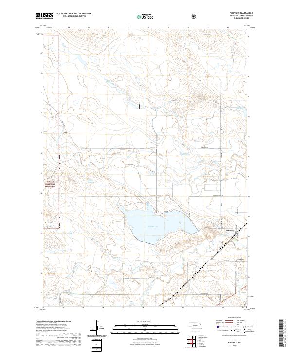 2021 Whitney2021 Print · USGSThe village of Whitney and the expansive Whitney Lake define this high plains landscape during the early 2020s. Researchers can trace rural cemetery locations like Whitney Cem or explore the boundaries of the Oglala National Grassland.
 - 2021 Map of Box Butte Reservoir West, 2021 Print
 2021 Box Butte Reservoir West2021 Print · USGSThe Nebraska panhandle's agricultural and riverine landscape is captured here during the early twenty-first century. Researchers can trace the western banks of Box Butte Reservoir and the rural course of the Niobrara River near Hollibaugh Rd.
 - 2021 Map of Marsland, 2021 Print
 2021 Marsland2021 Print · USGSCovers Dawes County, including Marsland, Box Butte County, and other nearby areas
 - 2021 Map of Coffee Mill Butte SE, 2021 Print
 2021 Coffee Mill Butte SE2021 Print · USGSDawes County in the early twenty-first century remains a landscape of open range and section-line roads defined by its creek drainages. Researchers can trace the layout of the Nebraska National Forest and local history markers like Cottonwood School Rd and Autogate Rd.
 - 2021 Map of Marsland NW, 2021 Print
 2021 Marsland NW2021 Print · USGSDawes County cattle country and the high plains of western Nebraska appear here in the early twenty-first century. Researchers can trace land ownership patterns and local landmarks like Pine Ridge, Morava Rd, and the meandering Niobrara River.
 - 2021 Map of Bohemian Creek, 2021 Print
 2021 Bohemian Creek2021 Print · USGSDawes County ranchlands are documented here in the early twenty-first century, showing a landscape defined by the White River and essential prairie water works. Researchers can trace local drainage patterns and land use via Gorr Reservoir Number 1, Morris Reservoir, and Bohemian Cr.
 - 2021 Map of Lone Tree Ranch, 2021 Print
 2021 Lone Tree Ranch2021 Print · USGSDawes County ranch land is captured in this modern survey of the Nebraska panhandle’s drainage systems and cattle country. Researchers can trace the water sources essential to the region, including Bauer Reservoir and the winding course of Lone Tree Cr.
 - 2021 Map of Box Butte Reservoir East, 2021 Print
 2021 Box Butte Reservoir East2021 Print · USGSThe Nebraska Panhandle's rural landscape comes into focus in this recent study of the Dawes and Box Butte county line. Trace the path of the Niobrara River through the Box Butte Reservoir and locate legacy sites along Cottonwood School Rd.
 - 2021 Map of Box Butte NE, 2021 Print
 2021 Box Butte NE2021 Print · USGSThe High Plains of western Nebraska meet where Dawes, Sheridan, and Box Butte counties converge in the early twenty-first century. Researchers can trace the essential water routes of the Niobrara River and Mirage Flats Canal across this rural landscape.
 - 2021 Map of Kings Canyon, 2021 Print
 2021 Kings Canyon2021 Print · USGSDawes County is shown in this contemporary survey of the Pine Ridge region, where forest management and rugged canyons meet high-plains ranching. Researchers can trace the network of the Pine Ridge Mt Bike Trl through the Nebraska National Forest and locate rural routes like Spotted Tail Rd.
 - 2021 Map of Chadron NE, 2021 Print
 2021 Chadron NE2021 Print · USGSThe Nebraska panhandle landscape near the Sheridan and Dawes county line is documented here in the early 2020s. Researchers can locate family landmarks like the Beaver Valley Cemetery and trace the paths of White River and Slim Butte Road.
 - 2021 Map of Wolf Butte, 2021 Print
 2021 Wolf Butte2021 Print · USGSThe Oglala National Grassland in Dawes County is shown here in the early twenty-first century. Researchers can trace landforms like Strawstack Butte and the Waldon Hills alongside water features including McMeekin Reservoir and Horsehead Cr.
 - 2021 Map of Crawford, 2021 Print
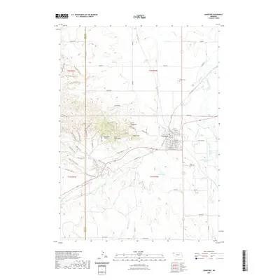 2021 Crawford2021 Print · USGSCovers Dawes County, including Crawford, Bowen Precinct, and other nearby areas
Showing maps 1-25 of 44
Top cities of Dawes County
Frequently asked questions
- What are the different types of historical maps available for Dawes County?
- What is the oldest map of Dawes County?
- Where can I purchase historical maps of Dawes County for my home or office?
- Where can I download high-res historical maps of Dawes County?
- Are there historical topographic maps available for Dawes County?
- Is there historical aerial imagery available for Dawes County?
- Where are historical maps of Dawes County sourced from?