1940s Maps of Dawes County, Nebraska
Explore 7 historic maps of Dawes County from the 1940s. These maps offer a rare glimpse into what life looked like during the 1940s — showing old roads, neighborhoods, homes, and landmarks that have changed or disappeared over time.
Whether you're researching your family's past, planning a metal detecting trip, or studying how Dawes County's landscape evolved across the 1940s, these high-resolution maps are a powerful tool for exploring the history of this region.
- Focus on a specific era: All maps on this page are from the 1940s, giving you a focused view of this time period.
- See what’s changed: Compare century-old streets, trails, and buildings to today's modern landscape using overlays and satellite layers.
- Research with precision: Use these maps for genealogy, historical research, land use analysis, or educational projects.
- View, download, or print: Maps are fully viewable online in high resolution, and can be downloaded or printed for your own records.
Start exploring Dawes County's history through authentic maps from the 1940s. This is your window into the past.
Dawes County, NE maps
(7)- 1946 Map of Box Butte Reservoir West, 1978 Print
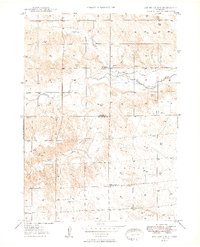
 1946 Box Butte Reservoir West1978 Print · USGSThe Nebraska Panhandle's ranching country comes into focus in this mid-century survey, documenting the early years of the Box Butte Reservoir. Genealogists and local historians can locate remote landmarks such as Sch No 62, Sch No 50, and the breaks of Sand Canyon.
 - 1947 Map of Box Butte NE, 1976 Print
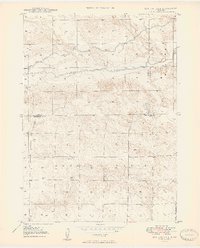
 1947 Box Butte NE1976 Print · USGSNorthwestern Nebraska at the end of the 1940s reveals a ranching landscape shaped by the Niobrara River and early irrigation projects. Researchers can locate remote homestead Windmills and the site of School No 80 near the Irrigation Canal.2 unique versions available
 - 1947 Map of Box Butte NW, 1977 Print
 1947 Box Butte NW1977 Print · USGSThe Niobrara River valley in the late 1940s reveals a high plains landscape shaped by early irrigation and ranching. Genealogists and historians can trace local landmarks like Kattn Cem, the Dunlap Sch, and scientific sites including the Fossil Beds.
 - 1948 Map of Box Butte Reservoir West
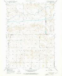
 1948 Box Butte Reservoir West1948 Print · USGSThe Nebraska high plains meet the headwaters of the Niobrara River in the late 1940s, just as the reservoir began to transform the local landscape. Researchers can locate remote rural schoolhouses like Sch No 52 and trace the early route of the Chicago Burlington and Quincy railroad.2 unique versions available
 - 1948 Map of Box Butte Reservoir East
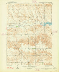
 1948 Box Butte Reservoir East1948 Print · USGSThe Nebraska panhandle comes into focus just after the war as the Box Butte Dam begins to reshape the Niobrara River valley. Researchers can trace rural school districts like Sch No 17 and explore the rugged breaks of Sand Canyon.
 - 1949 Map of Box Butte NE
 1949 Box Butte NE1949 Print · USGSNorthwest Nebraska's high plains meet the winding Niobrara River during the late 1940s, a time when water meant survival for remote ranching families. Researchers can trace rural school districts like School No 80 and identify dozens of historic Windmill sites across Pepper Creek.2 unique versions available
 - 1949 Map of Box Butte NW
 1949 Box Butte NW1949 Print · USGSIn the high plains of western Nebraska after the war, this area of Dawes and Box Butte counties shows a landscape defined by ranching and river water. Researchers can trace rural life through landmarks like Running Water Sch, the Katen Cem, and the unique Fossil Beds.2 unique versions available
End of results
Showing maps 1-7 of 7
Top cities of Dawes County
Frequently asked questions
- What are the different types of historical maps available for Dawes County?
- What is the oldest map of Dawes County?
- Where can I purchase historical maps of Dawes County for my home or office?
- Where can I download high-res historical maps of Dawes County?
- Are there historical topographic maps available for Dawes County?
- Is there historical aerial imagery available for Dawes County?
- Where are historical maps of Dawes County sourced from?