Old Maps of City Offices, Nebraska for Metal Detecting
Plan your next treasure hunt with 15 historic maps of City Offices. Find old homesites, ghost towns, trails, and gathering spots that may be lost to time — perfect for identifying promising metal detecting locations.
- Locate forgotten sites: Uncover places like long-lost settlements, abandoned rail lines, or gathering spots.
- Plan better hunts: Use map overlays combined with LiDAR or satellite views to narrow in on historically rich areas.
- Made for detectorists: Thousands of hobbyists use these maps to discover relics, coins, and hidden history.
Use these historic maps to boost your research and find new opportunities beneath the surface of City Offices.
City Offices, NE maps
(15)- 1955 Map of Alliance, 1966 Print
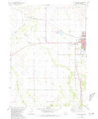
 1955 Alliance1966 Print · USGSThe Nebraska panhandle comes into sharp focus during the mid-fifties, showing a landscape defined by the Niobrara River and the expanding Sand Hills. Researchers can trace the grounds of Fort Robinson, locate Saint Marys Church, or follow the Chicago Burlington and Quincy rail line through Hemingford.3 unique versions available
 - 1957 Map of Alliance
 1957 Alliance1957 Print · USGSNorthwest Nebraska in the mid-fifties is captured here as a landscape of rail hubs, sprawling cattle ranches, and the eastern edge of the dunes. Genealogists and historians can trace rail lines through Alliance and Chadron or locate landmarks like Saint Marys Church and the Agate Spring Fossil Beds.
 - 1958 Map of Alliance
 1958 Alliance1958 Print · USGSNorthwestern Nebraska in the late fifties shows a landscape shaped by the legacy of the high plains frontier and modern agricultural expansion. Genealogists and historians can trace rail-line settlements and landmarks like Fort Robinson and the Agate Spring Fossil Beds.
 - 1970 Map of Chadron East, 1972 Print
 1970 Chadron East1972 Print · USGSChadron and the surrounding Nebraska Panhandle are captured in the early 1970s, showing the town's expansion and its rail connections. Genealogists and historians can trace the grounds of Chadron State College, Highland Cem, and Assumption Academy.
 - 1980 Map of Chadron West, 1981 Print
 1980 Chadron West1981 Print · USGSChadron and the White River valley are documented here in the early eighties as the town's educational and rail connections flourished. Researchers can trace the grounds of Chadron State College, find Dakota Junction, and locate rural landmarks like Shisler Cem.2 unique versions available
 - 1985 Map of Gordon
 1985 Gordon1985 Print · USGSSheridan County and the High Plains thrive along the rail lines during the mid-eighties as agriculture and aviation modernize the region. Trace family roots and land patterns near Rushville, the Nebraska National Forest, and the Old Indian Treaty Boundary.2 unique versions available
 - 1986 Map of Crawford
 1986 Crawford1986 Print · USGSThe Nebraska Panhandle in the mid-eighties shows a high-plains landscape defined by its rugged geology and major rail corridors. Genealogists and historians can trace the paths of the Burlington Northern railroad through settlements like Orella, Glen, and Harrison.2 unique versions available
 - 2011 Map of Chadron West, 2011 Print
 2011 Chadron West2011 Print · USGSCovers City Offices, including Dakota Junction, Dawes County, and other nearby areas
 - 2011 Map of Chadron East, 2011 Print
 2011 Chadron East2011 Print · USGSCovers City Offices, including Dawes County, United States, and other nearby areas
 - 2014 Map of Chadron East, 2014 Print
 2014 Chadron East2014 Print · USGSCovers City Offices, including Dawes County, United States, and other nearby areas
 - 2014 Map of Chadron West, 2014 Print
 2014 Chadron West2014 Print · USGSCovers City Offices, including Dakota Junction, Dawes County, and other nearby areas
 - 2017 Map of Chadron West, 2017 Print
 2017 Chadron West2017 Print · USGSCovers City Offices, including Dakota Junction, Dawes County, and other nearby areas
 - 2017 Map of Chadron East, 2017 Print
 2017 Chadron East2017 Print · USGSCovers City Offices, including Dawes County, United States, and other nearby areas
 - 2021 Map of Chadron East, 2021 Print
 2021 Chadron East2021 Print · USGSChadron and the surrounding Nebraska High Plains are documented here during the early twenty-first century as the city meets the national forest. Local historians can trace the paths of the Cowboy Trl or locate the Highland Cem and Marshall Reservoir among the creeks.
 - 2021 Map of Chadron West, 2021 Print
 2021 Chadron West2021 Print · USGSDawes County enters a new decade as a bustling educational and civic center surrounded by the sprawling plains of the Nebraska Panhandle. Researchers can trace the legacy of local families at Greenwood Cemetery or explore the campus layout of Chadron State College.
End of results
Showing maps 1-15 of 15
Top cities near City Offices
Top neighborhoods of City Offices
- Prairie Pines Retirement Community historical maps
- Redwood Mobile Court historical maps
- Westview Mobile Park historical maps
Frequently asked questions
- What are the different types of historical maps available for City Offices?
- What is the oldest map of City Offices?
- Where can I purchase historical maps of City Offices for my home or office?
- Where can I download high-res historical maps of City Offices?
- Are there historical topographic maps available for City Offices?
- Is there historical aerial imagery available for City Offices?
- Where are historical maps of City Offices sourced from?