1960s Maps of Wheeler County, Nebraska
Explore 7 historic maps of Wheeler County from the 1960s. These maps offer a rare glimpse into what life looked like during the 1960s — showing old roads, neighborhoods, homes, and landmarks that have changed or disappeared over time.
Whether you're researching your family's past, planning a metal detecting trip, or studying how Wheeler County's landscape evolved across the 1960s, these high-resolution maps are a powerful tool for exploring the history of this region.
- Focus on a specific era: All maps on this page are from the 1960s, giving you a focused view of this time period.
- See what’s changed: Compare century-old streets, trails, and buildings to today's modern landscape using overlays and satellite layers.
- Research with precision: Use these maps for genealogy, historical research, land use analysis, or educational projects.
- View, download, or print: Maps are fully viewable online in high resolution, and can be downloaded or printed for your own records.
Start exploring Wheeler County's history through authentic maps from the 1960s. This is your window into the past.
Wheeler County, NE maps
(7)- 1960 Map of Spalding 2 SW, 1961 Print
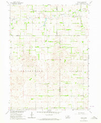
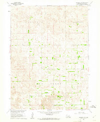 1960 Spalding 2 SW1961 Print · USGSWheeler County ranching country is shown at the start of the sixties, documenting a landscape of rolling sandhills and section-line roads. Genealogists and local historians can pinpoint rural school sites like School No 20 and School No 24 near the path of Mud Creek.3 unique versions available
 - 1960 Map of Spalding 2 NW, 1961 Print
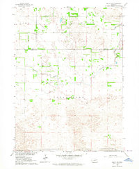
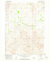 1960 Spalding 2 NW1961 Print · USGSWheeler County ranching culture comes into focus at the dawn of the sixties, where life centered on the water of Beaver Creek. Researchers can trace old family holdings like Stokes Ranch and locate the rural Wayside Sch.3 unique versions available
 - 1960 Map of Spalding 2 NE, 1962 Print
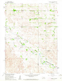 1960 Spalding 2 NE1962 Print · USGSThe rural borderlands of Wheeler and Antelope counties appear here as they were in the early 1960s, prior to widespread school consolidation. Genealogists can trace early landmarks like Park Ch and several district schools, such as Sunnyside Sch and School No 27.3 unique versions available
 - 1960 Map of Spalding 2 SE, 1962 Print
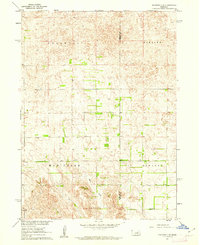 1960 Spalding 2 SE1962 Print · USGSWheeler and Boone counties in the early sixties reveal a landscape of dispersed ranching townships and rural school districts. Genealogists and local historians can trace the locations of School No 39, School No 19, and the small Cem near the banks of Mud Creek.3 unique versions available
 - 1963 Map of Deloit, 1964 Print
 1963 Deloit1964 Print · USGSAgricultural life in the early sixties centers on the rural township of Deloit. Researchers can trace the network of country schoolhouses like School No 60, find family landmarks at Knievels Corner, or locate the Wolf Cem.2 unique versions available
 - 1963 Map of Deloit SW, 1964 Print
 1963 Deloit SW1964 Print · USGSWheeler and Holt counties appear here in the early sixties as a landscape of remote ranching and rural township life. Genealogists and local historians can locate St Anthonys Cem, the remote School No 146, and the winding course of Clearwater Creek.2 unique versions available
 - 1969 Map of O'Neill
 1969 O'Neill1969 Print · USGSCentral Nebraska in the mid-fifties is defined here by the expansive Sand Hills and the winding Niobrara River. Trace the Chicago and North Western rail line through cattle towns like O'Neill and Ainsworth.
End of results
Showing maps 1-7 of 7
Top cities of Wheeler County
Frequently asked questions
- What are the different types of historical maps available for Wheeler County?
- What is the oldest map of Wheeler County?
- Where can I purchase historical maps of Wheeler County for my home or office?
- Where can I download high-res historical maps of Wheeler County?
- Are there historical topographic maps available for Wheeler County?
- Is there historical aerial imagery available for Wheeler County?
- Where are historical maps of Wheeler County sourced from?