Old Maps of Pershing County, Nevada for Metal Detecting
Plan your next treasure hunt with 706 historic maps of Pershing County. Find old homesites, ghost towns, trails, and gathering spots that may be lost to time — perfect for identifying promising metal detecting locations.
- Locate forgotten sites: Uncover places like long-lost settlements, abandoned rail lines, or gathering spots.
- Plan better hunts: Use map overlays combined with LiDAR or satellite views to narrow in on historically rich areas.
- Made for detectorists: Thousands of hobbyists use these maps to discover relics, coins, and hidden history.
Use these historic maps to boost your research and find new opportunities beneath the surface of Pershing County.
Pershing County, NV maps
(706)- 1886 Map of Granite Range
 1886 Granite Range1886 Print · USGSNorthwestern Nevada in the late nineteenth century was a frontier of great lakes and dry basins. Researchers can trace early geography from the Salt Works 3830 in the northern flats to water sources like Sheep-head Spring and Hot Springs.
 - 1890 Map of Wadsworth, 1954 Print
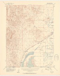
 1890 Wadsworth1954 Print · USGSNorthern Nevada's high desert reveals its late 19th-century rail and water patterns along the border of Washoe and Churchill counties. Local historians can trace the route of the Central Pacific Railroad through Wadsworth or locate the site of the Eagle Salt Works and the Piute Indian Agency.
 - 1892 Map of Wadsworth
 1892 Wadsworth1892 Print · USGSWestern Nevada at the close of the frontier era centers on the vital Truckee River corridor and the Central Pacific Railroad. Genealogists and historians can trace early settlements and infrastructure like the Piute Indian Agency, Eagle Salt Works, and the town of Wadsworth.
 - 1894 Map of Granite Range
 1894 Granite Range1894 Print · USGSNorthwestern Nevada was a landscape of stark basins and vital springs during the late nineteenth century. Researchers can trace the early industrial footprint of the Salt Works 3830 and locate perennial water sources like Sheep-head Spring and Smoke Creek.7 unique versions available
 - 1894 Map of Wadsworth
 1894 Wadsworth1894 Print · USGSWashoe and Churchill counties are captured in the 1890s at a critical junction of the transcontinental rail line and the Truckee River. Genealogists and historians can trace early Great Basin life through landmarks like the Piute Indian Agency, Wadsworth, and the Eagle Salt Works.5 unique versions available
 - 1908 Map of Carson Sink, 1954 Print
 1908 Carson Sink1954 Print · USGSChurchill County at the opening of the century reveals a landscape of desert mining camps and nascent river irrigation. Genealogists and historians can trace the early streets of Fallon, the remote Nevada Hills Mine, and the location of Dixie.3 unique versions available
 - 1910 Map of Carson Sink
 1910 Carson Sink1910 Print · USGSWestern Nevada at the end of the first decade of the century shows a landscape defined by desert mining camps and the burgeoning Carson-Truckee irrigation projects. Genealogists and historians can trace the early streets of Fallon or locate remote camps like Rawhide and the Nevada Wonder Mine.5 unique versions available
 - 1931 Map of Lovelock, 1955 Print
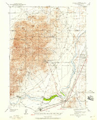
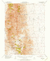
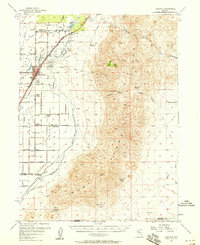
 1931 Lovelock1955 Print · USGSPershing County's high-desert mining landscape is frozen in time during the early 1930s, as gold and tungsten districts drove the local economy. Genealogists and historians can trace the foundations of Unionville, the industrial footprint of the Nevada Massachusetts Tungsten Mine, and the route of the Victory Highway.
 - 1932 Map of Sonoma Range, 1955 Print
 1932 Sonoma Range1955 Print · USGSNorthern Nevada in the early thirties is captured here along the Humboldt River and its flanking desert ranges. Genealogists and historians can trace numerous family-named landmarks like Prida Ranch and Childress Ranch, or locate the Site of Old Indian Fort and Barber Sch.5 unique versions available
 - 1935 Map of Lovelock
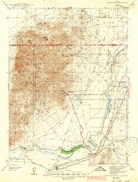
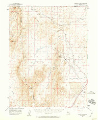
 1935 Lovelock1935 Print · USGSPershing County in the mid-1930s is a landscape of high-desert mining camps and essential rail hubs along the Humboldt. Researchers can trace the legacy of the silver and tungsten booms at Rochester, the Sulphur Mine, and the now-quiet streets of Unionville or Mazuma.3 unique versions available
 - 1939 Map of Sonoma Range
 1939 Sonoma Range1939 Print · USGSHigh-desert ranching and deep-earth mining define this Nevada landscape during the late thirties. Researchers can trace historical family holdings like Seven Devils Ranch, early educational sites such as Pearce Sch, and industrial landmarks including the Copper Canyon Mine.5 unique versions available
 - 1939 Map of Eugene Mountains Area, 1958 Print
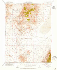
 1939 Eugene Mountains Area1958 Print · USGSPershing County's mining and transportation history are frozen in time just before the war as tungsten extraction peaked in the desert. Genealogists and historians can trace the Emigrant Trail and Old Stage Road alongside industrial landmarks like the Nevada Massachusetts Tungsten Mine and Mill City.3 unique versions available
 - 1942 Map of Eugene Mountains Area
 1942 Eugene Mountains Area1942 Print · USGSPershing and Humboldt counties were centers of mining and transit during the early Forties. Genealogists and historians can trace the intersection of the Emigrant Trail with industrial sites like the Nevada Massachusetts Tungsten Mine and ranching life at Thackers Ranch.2 unique versions available
 - 1951 Map of Carson Sink, 1953 Print
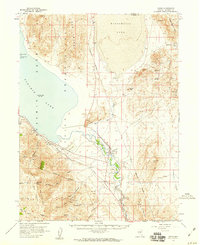
 1951 Carson Sink1953 Print · USGSThe high desert of Churchill County is captured here in the early fifties, documenting a landscape of ancient caves and historic migration routes. Trace the paths of the Old California Trail Road and the St Anthony Mine near the vast Humboldt Lake.4 unique versions available
 - 1951 Map of Desert Peak, 1953 Print
 1951 Desert Peak1953 Print · USGSThe Nevada desert in the early fifties reveals a landscape shaped by both pioneer migration and the search for minerals. Researchers can trace the Old California Trail and locate several active workings like the Mule Train Mines and Jessup.3 unique versions available
 - 1954 Map of Unionville, 1956 Print
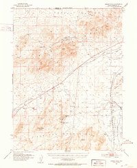
 1954 Unionville1956 Print · USGSPershing County mining history is preserved here during the mid-fifties, showing the rugged network of silver camps and trails. You can trace the development of Unionville and Rochester alongside specific operations like the Arizona Mine and Nevada Packard Mines.3 unique versions available
 - 1954 Map of Buffalo Mtn, 1956 Print
 1954 Buffalo Mtn1956 Print · USGSNevada's high-desert mining landscape is captured here during the mid-fifties, showing a terrain defined by mercury extraction and historic trails. Trace the path of the Old Emigrant Jeep Trail or locate the Nevada Quicksilver Mine and Green Gold Mine.3 unique versions available
 - 1955 Map of Lovelock, 1963 Print
 1955 Lovelock1963 Print · USGSNorthwestern Nevada’s vast desert basins and military ranges are captured here in the mid-fifties, showing a landscape defined by the Humboldt River and the great Pyramid Lake. Genealogists and historians can trace isolated rail stops like Gerlach and Empire, or locate historic workings such as the Golden Eagle Mine and Pershing Mine.5 unique versions available
 - 1955 Map of Winnemucca, 1968 Print
 1955 Winnemucca1968 Print · USGSNorthern Nevada's high desert corridor is captured here in the mid-fifties, centered on the river-and-rail hub of Winnemucca. Researchers can trace the dual tracks of the Southern Pacific and Western Pacific railroads through towns like Golconda and Valmy.3 unique versions available
 - 1956 Map of Oreana, 1957 Print
 1956 Oreana1957 Print · USGSThe Humboldt River corridor in the mid-1950s reveals a landscape defined by ranching, rail, and the remains of the mining era. Genealogists and historians can locate family landmarks like Cerini Ranch (Site), the mining works at Arabia, and early routes such as the Emigrant Road.3 unique versions available
 - 1956 Map of Toulon, 1957 Print
 1956 Toulon1957 Print · USGSThe Nevada desert near the Humboldt Sink comes into focus in the mid-1950s, revealing a landscape shaped by mining, ranching, and the railroad. Genealogists and historians can trace family operations like Arobio Ranch or locate the Coon Can Mines and Lone Mtn Cemetery.4 unique versions available
 - 1956 Map of Imlay, 1958 Print
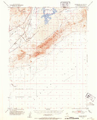
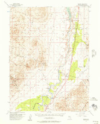
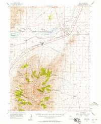 1956 Imlay1958 Print · USGSPershing County's mining and transit history is preserved here in the mid-1950s as the rail town of Imlay supports the surrounding silver and fluorspar districts. Trace the legacy of the Old Emigrant Trail past the Humboldt City (Site) and active workings like the Queen of Sheba Mine.3 unique versions available
 - 1956 Map of Lovelock, 1958 Print
 1956 Lovelock1958 Print · USGSIn the mid-1950s, the irrigation and mining infrastructure of Pershing County reached a peak of development along the Humboldt River. Trace ancestral homesteads at the Circle L Ranch, locate early mining claims like the Muttlebury Mine, or follow the historic path of the Old Emigrant Road.3 unique versions available
 - 1957 Map of Fireball Ridge, 1959 Print
 1957 Fireball Ridge1959 Print · USGSThe high desert of Churchill County comes into sharp focus during the late fifties, showing a landscape defined by mining prospects and critical water sources. Researchers can trace remote industrial activity at the Jay Bird Mine or locate vital springs like Black Warrior Spring and Coyote Spring.2 unique versions available
 - 1957 Map of Nixon, 1959 Print
 1957 Nixon1959 Print · USGSThe Pyramid Lake Indian Reservation is shown in the late fifties as a landscape of terminal lakes and high desert peaks. Genealogists and researchers can trace the Southern Pacific rail corridor near Nixon or locate remote sites like Rosebush Spr and Marble Bluff.3 unique versions available
Showing maps 1-25 of 706
Top cities of Pershing County
- Lovelock historical maps
- Humboldt River Ranch historical maps
- Imlay historical maps
- Unionville historical maps
Frequently asked questions
- What are the different types of historical maps available for Pershing County?
- What is the oldest map of Pershing County?
- Where can I purchase historical maps of Pershing County for my home or office?
- Where can I download high-res historical maps of Pershing County?
- Are there historical topographic maps available for Pershing County?
- Is there historical aerial imagery available for Pershing County?
- Where are historical maps of Pershing County sourced from?