1950s Maps of Washoe County, Nevada
Explore 33 historic maps of Washoe County from the 1950s. These maps offer a rare glimpse into what life looked like during the 1950s — showing old roads, neighborhoods, homes, and landmarks that have changed or disappeared over time.
Whether you're researching your family's past, planning a metal detecting trip, or studying how Washoe County's landscape evolved across the 1950s, these high-resolution maps are a powerful tool for exploring the history of this region.
- Focus on a specific era: All maps on this page are from the 1950s, giving you a focused view of this time period.
- See what’s changed: Compare century-old streets, trails, and buildings to today's modern landscape using overlays and satellite layers.
- Research with precision: Use these maps for genealogy, historical research, land use analysis, or educational projects.
- View, download, or print: Maps are fully viewable online in high resolution, and can be downloaded or printed for your own records.
Start exploring Washoe County's history through authentic maps from the 1950s. This is your window into the past.
Washoe County, NV maps
(33)- 1950 Map of Chilcoot, 1952 Print
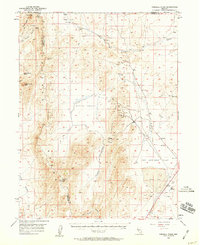
 1950 Chilcoot1952 Print · USGSThe high Sierra gateway at Beckwourth Pass is documented here at mid-century as the railroad and highway networks expanded. Researchers can trace the routes of the Western Pacific and locate local landmarks like Summit Sch and Hallelujah Junction.5 unique versions available
 - 1950 Map of Virginia City, 1955 Print
 1950 Virginia City1955 Print · USGSVirginia City and the Comstock mining corridor are seen here at mid-century, amidst a dense concentration of historic shafts and early settlement sites. Researchers can trace the legacy of silver mining through Gold Hill, the Utah Shaft, and several cemeteries that overlook the mountain ranges.3 unique versions available
 - 1950 Map of Mt. Rose, 1956 Print
 1950 Mt. Rose1956 Print · USGSMid-century Nevada comes into focus as the Reno area expands south toward the Washoe Valley and the high peaks of the Toiyabe National Forest. Genealogists and historians can trace old homesteads near Franktown, the Ophir Mill Site, and the grounds of the Bowers Mansion.3 unique versions available
 - 1950 Map of Reno, 1957 Print
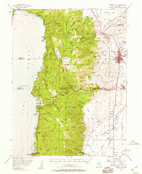
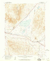
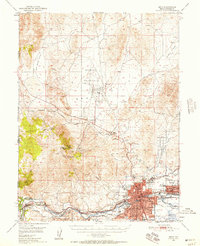 1950 Reno1957 Print · USGSMid-century Reno and Sparks appear here alongside the vital irrigation networks that sustained the Truckee Meadows. Researchers can trace the development of older neighborhoods and outlying sites like Poeville (Site), the Reno Fair Grounds, and Skyline Airfield.3 unique versions available
 - 1951 Map of Reno
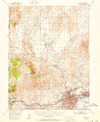 1951 Reno1951 Print · USGSMid-century Nevada comes into focus as Reno and Sparks expand along the Truckee River and transcontinental rail lines. Trace family history and local industry through features like Mtnview Cem, the Golden Fleece Mine, and early aviation at Skyline Airfield.2 unique versions available
 - 1952 Map of Mt. Rose
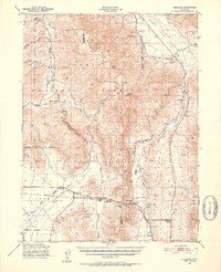
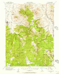
 1952 Mt. Rose1952 Print · USGSWashoe County at the start of the 1950s reveals a transition from alpine wilderness to valley ranching and early suburban growth. You can trace historical landmarks like the Ophir Mill Site, Bowers Mansion, and the winding path of the Truckee Ditch.
 - 1952 Map of Virginia City
 1952 Virginia City1952 Print · USGSStorey County's mining heartland is revealed in the mid-century, documenting the legendary Comstock Lode settlements and engineering works. Researchers can trace the massive Sutro Tunnel, locate the Lousetown (Site), and find family roots in Gold Hill or Virginia City.2 unique versions available
 - 1954 Map of Vya, 1967 Print
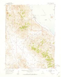
 1954 Vya1967 Print · USGSThe tri-state corner of Nevada, Oregon, and California appears here in the mid-fifties, dominated by wildlife refuges and massive naval gunnery ranges. Trace isolated high-desert outposts like Vya and Soldier Meadow Ranch or find historic workings at the Ashdown Mine.3 unique versions available
 - 1954 Map of Alturas, 1968 Print
 1954 Alturas1968 Print · USGSThe Modoc Plateau and Surprise Valley appear in the mid-1950s as a landscape of remote ranching towns and vast wildlife refuges. Researchers can trace early settlements like Fort Bidwell, locate the McArthur Grain Elevator, and follow the Southern Pacific rail lines.4 unique versions available
 - 1955 Map of Kings Beach, 1956 Print
 1955 Kings Beach1956 Print · USGSThe north shore of Lake Tahoe is captured during the mid-fifties, showing the growth of resort communities along the California-Nevada line. Trace early lakeside developments from Brockway to Carnelian Bay, or locate local landmarks like the Fish Hatchery and Brockway Golf Club.4 unique versions available
 - 1955 Map of Loyalton, 1957 Print
 1955 Loyalton1957 Print · USGSThe Sierra Valley and the high timberlands of the California-Nevada border come alive in the mid-fifties. Genealogists can trace the Loyalton Cem and isolated outposts like Balls Ranch or the Flying Dutchman Mine.4 unique versions available
 - 1955 Map of Truckee, 1957 Print
 1955 Truckee1957 Print · USGSThe High Sierra near the Nevada border comes alive in the mid-fifties as a crossroads of rail history and pioneer memory. Researchers can trace the Southern Pacific Railroad through the canyon to Truckee or locate historic spots like the Joerger Ranch and Hobart Mills.4 unique versions available
 - 1955 Map of Boca, 1957 Print
 1955 Boca1957 Print · USGSThe California-Nevada borderlands in the mid-1950s show a landscape defined by the Truckee River and mountain rail transit. Trace the Southern Pacific line through Floriston, find the Boca Dam spillway, or locate the lookout atop Verdi Peak.7 unique versions available
 - 1955 Map of Martis Peak, 1957 Print
 1955 Martis Peak1957 Print · USGSThe High Sierra at the Nevada-California line appears here in the mid-fifties, dominated by the Southern Pacific rail corridor and high timberlands. Trace the locations of the Old Joerger Ranch, the historic Union Mills (Site), and the fire lookout atop Martis Peak.5 unique versions available
 - 1955 Map of Marlette Lake, 1957 Print
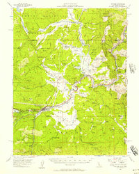
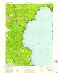
 1955 Marlette Lake1957 Print · USGSThe eastern Nevada shoreline of Lake Tahoe in the mid-1950s reveals a landscape of high-altitude water engineering and steep mountain peaks. Researchers can trace the Virginia City Water Supply Flume and find landmarks like the Incline Guard Sta and Marlette Lake.4 unique versions available
 - 1955 Map of Tahoe, 1958 Print
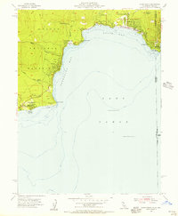
 1955 Tahoe1958 Print · USGSThe northwest shore of Lake Tahoe in the mid-fifties reveals a developing landscape of lakeside lodges and mountain retreats. Genealogists and historians can trace old community footprints from Tahoe City to Meeks Bay, or locate landmarks like Chambers Lodge and the Ngorchester Mine.3 unique versions available
 - 1955 Map of Lovelock, 1963 Print
 1955 Lovelock1963 Print · USGSNorthwestern Nevada’s vast desert basins and military ranges are captured here in the mid-fifties, showing a landscape defined by the Humboldt River and the great Pyramid Lake. Genealogists and historians can trace isolated rail stops like Gerlach and Empire, or locate historic workings such as the Golden Eagle Mine and Pershing Mine.5 unique versions available
 - 1956 Map of Dayton, 1958 Print
 1956 Dayton1958 Print · USGSThe silver-country landscape around the Carson River is shown here in the mid-1950s, bridging the mining era and modern institutional development. Researchers can trace the Old RR Grade and locate historic sites such as Mound House and the Daney Mine.3 unique versions available
 - 1956 Map of Carson City, 1958 Print
 1956 Carson City1958 Print · USGSIn the mid-fifties, the Nevada state capital and the eastern shores of Lake Tahoe remained distinct, separated by the Carson Range. You can trace institutional history at Stewart and the State Capitol, or locate old burials at Jacks Valley Cemetery.4 unique versions available
 - 1957 Map of Sutcliffe, 1959 Print
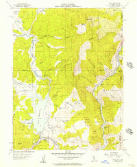
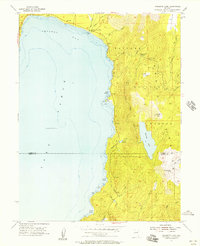
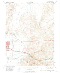
 1957 Sutcliffe1959 Print · USGSThe western shores of Pyramid Lake and the high desert ranges of Washoe County are captured here during the late fifties. Local researchers can trace the rail-and-ranch economy through features like the Southern Pacific line, Sutcliffe, and the New Dominion Mine.2 unique versions available
 - 1957 Map of Fireball Ridge, 1959 Print
 1957 Fireball Ridge1959 Print · USGSThe high desert of Churchill County comes into sharp focus during the late fifties, showing a landscape defined by mining prospects and critical water sources. Researchers can trace remote industrial activity at the Jay Bird Mine or locate vital springs like Black Warrior Spring and Coyote Spring.2 unique versions available
 - 1957 Map of Vista, 1959 Print
 1957 Vista1959 Print · USGSSparks and the Truckee River corridor are captured during a period of mid-century growth and industrial expansion. Genealogists and local historians can trace the development of neighborhood schools like Lincoln Park Sch or locate the Dominican Brothers Monastery and the railroad stop at Vista.2 unique versions available
 - 1957 Map of Dogskin Mountain, 1959 Print
 1957 Dogskin Mountain1959 Print · USGSThe high desert basins along the Nevada-California line are mapped here during the late fifties, showing a landscape defined by ranching and mining. Researchers can trace remote water sources like McKissick Spring and historic operations at Hungry Mountain or the Renner Well.3 unique versions available
 - 1957 Map of Spanish Springs Valley, 1959 Print
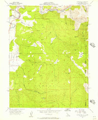
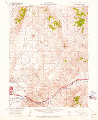 1957 Spanish Springs Valley1959 Print · USGSWashoe County at the end of the fifties shows the transition from historic ranching life to early suburban growth. Genealogists and historians can trace the Southern Pacific corridor through Mustang and Hafed or locate family sites like the Wilcox Ranch and Home Ranch.3 unique versions available
 - 1957 Map of Two Tips, 1959 Print
 1957 Two Tips1959 Print · USGSThe high-desert terrain of central Nevada is captured here during the late 1950s, showing a landscape shaped by rail and irrigation. Genealogists and historians can trace the Southern Pacific corridor through Hazen and Argo, or locate the abandoned salt evaporators and early prospects.2 unique versions available
Showing maps 1-25 of 33
Top cities of Washoe County
- Reno historical maps
- Sparks historical maps
- Cold Springs historical maps
- Lemmon Valley historical maps
- New Washoe City historical maps
- Golden Valley historical maps
See more
Frequently asked questions
- What are the different types of historical maps available for Washoe County?
- What is the oldest map of Washoe County?
- Where can I purchase historical maps of Washoe County for my home or office?
- Where can I download high-res historical maps of Washoe County?
- Are there historical topographic maps available for Washoe County?
- Is there historical aerial imagery available for Washoe County?
- Where are historical maps of Washoe County sourced from?