1920s Maps of Coos County, New Hampshire
Explore 7 historic maps of Coos County from the 1920s. These maps offer a rare glimpse into what life looked like during the 1920s — showing old roads, neighborhoods, homes, and landmarks that have changed or disappeared over time.
Whether you're researching your family's past, planning a metal detecting trip, or studying how Coos County's landscape evolved across the 1920s, these high-resolution maps are a powerful tool for exploring the history of this region.
- Focus on a specific era: All maps on this page are from the 1920s, giving you a focused view of this time period.
- See what’s changed: Compare century-old streets, trails, and buildings to today's modern landscape using overlays and satellite layers.
- Research with precision: Use these maps for genealogy, historical research, land use analysis, or educational projects.
- View, download, or print: Maps are fully viewable online in high resolution, and can be downloaded or printed for your own records.
Start exploring Coos County's history through authentic maps from the 1920s. This is your window into the past.
Coos County, NH maps
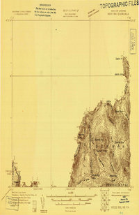
(7)- 1920 Map of Guildhall
 1920 Guildhall1920 Print · USGSThe upper Connecticut River valley is captured here in the early twentieth century as a bustling railroad corridor on the border of Vermont and New Hampshire. Genealogists can trace family names at Wheeler Corner or Hapgood Corner and locate regional hubs like North Stratford and Guildhall Station.
 - 1925 Map of Indian Stream
 1925 Indian Stream1925 Print · USGSThe northern tip of New Hampshire is captured here in the mid-1920s, showing a rugged territory of logging camps and border schools. Researchers can trace the lineage of remote settlements through Indian Stream School, Greeleys Camp, and the community at Happy Corner.
 - 1926 Map of Indian Stream
 1926 Indian Stream1926 Print · USGSUpper Coos County at the Canadian border comes alive in this survey of northern New Hampshire's timberlands and early settlements. Genealogists and historians can trace rural schoolhouses like Wheeler School and Indian Stream School, or locate old camps such as Happy Corner and Depot Camp.4 unique versions available
 - 1927 Map of Indian Stream
 1927 Indian Stream1927 Print · USGSThe northern reaches of Coos County are captured here in the mid-1920s, showing the remote borderlands between New Hampshire and Canada. Genealogists and historians can locate rural landmarks like the Clarksville Town Hall, the Wheeler School, and numerous timber camps like Varney Camp.5 unique versions available
 - 1927 Map of Moose Bog
 1927 Moose Bog1927 Print · USGSThe wilderness of the North Woods is charted in the late twenties along the border where Maine, New Hampshire, and Quebec meet. Researchers can trace the remote Bowman Farm and the high-elevation wetlands of Moose Bog and the Third East Branch Magalloway River.3 unique versions available
 - 1927 Map of Second Lake, 1955 Print
 1927 Second Lake1955 Print · USGSNorthern New Hampshire's high timberlands and the Connecticut River headwaters appear in the late twenties, spanning from the Canadian border down to the academy grants. Researchers can locate remote logging outposts like Depot Camp and Camp No 32 or trace the early shorelines of Second Lake and First Connecticut Lake.6 unique versions available
 - 1929 Map of Averill
 1929 Averill1929 Print · USGSThe northern borderlands of Vermont and New Hampshire appear here during the peak of the region's timber era. Trace the industrial landscape of the Maine Central RR and early logging outposts like Camp No 10 and Buzzell Dam.5 unique versions available
End of results
Showing maps 1-7 of 7
Top cities of Coos County
- Berlin historical maps
- Lancaster historical maps
- Gorham historical maps
- Whitefield historical maps
- Northumberland historical maps
- Colebrook historical maps
See more
Frequently asked questions
- What are the different types of historical maps available for Coos County?
- What is the oldest map of Coos County?
- Where can I purchase historical maps of Coos County for my home or office?
- Where can I download high-res historical maps of Coos County?
- Are there historical topographic maps available for Coos County?
- Is there historical aerial imagery available for Coos County?
- Where are historical maps of Coos County sourced from?