1980s Maps of Coos County, New Hampshire
Explore 46 historic maps of Coos County from the 1980s. These maps offer a rare glimpse into what life looked like during the 1980s — showing old roads, neighborhoods, homes, and landmarks that have changed or disappeared over time.
Whether you're researching your family's past, planning a metal detecting trip, or studying how Coos County's landscape evolved across the 1980s, these high-resolution maps are a powerful tool for exploring the history of this region.
- Focus on a specific era: All maps on this page are from the 1980s, giving you a focused view of this time period.
- See what’s changed: Compare century-old streets, trails, and buildings to today's modern landscape using overlays and satellite layers.
- Research with precision: Use these maps for genealogy, historical research, land use analysis, or educational projects.
- View, download, or print: Maps are fully viewable online in high resolution, and can be downloaded or printed for your own records.
Start exploring Coos County's history through authentic maps from the 1980s. This is your window into the past.
Coos County, NH maps
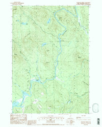
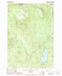
(46)- 1982 Map of Pliny Range, 1983 Print
 1982 Pliny Range1983 Print · USGSCoos County, New Hampshire, is captured in the early 1980s as a high-altitude landscape of small mountain villages and expansive forest. Genealogists and hikers can trace old family sites near Jefferson Highland or locate the Forest Vale Cem and St Johns Ch.
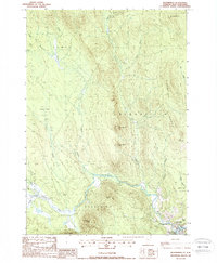
 - 1982 Map of Lancaster, 1983 Print
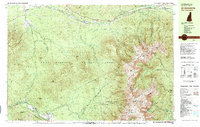
 1982 Lancaster1983 Print · USGSThe Connecticut River valley comes alive in the early eighties as a network of rail lines and riverside towns. Genealogists and historians can trace family-named hills and find local landmarks like St Matthews Ch, the Covered Bridge, and Riverside Cem.2 unique versions available
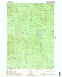
 - 1982 Map of Bethlehem, 1983 Print
 1982 Bethlehem1983 Print · USGSUpper Grafton and Coos County are shown in the early eighties as the mountain rail corridors still shaped local life. Genealogists and hikers can trace old family burial sites like Burns Cem, follow the Boston and Maine Railroad, or locate the Twin Mountain Fish Hatchery.
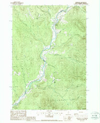
 - 1982 Map of Mt. Washington, 1983 Print
 1982 Mt. Washington1983 Print · USGSThe Presidential Range and its iconic summit are captured here in the early eighties, showing the region as a mature hub for mountain tourism and transit. Trace the historic paths of the Mount Washington Cog Railway, explore the high-altitude Lakes of the Clouds, and locate the Lady of the Mountain Ch at Bretton Woods.2 unique versions available
 - 1986 Map of Mount Washington
 1986 Mount Washington1986 Print · USGSThe northern New England highlands are shown here in the mid-eighties, centered on the high peaks and river valleys of the New Hampshire borderlands. Researchers can trace historic transportation lines like the Mount Washington Cog Railway and the Maine Central Railroad near Gorham and Lancaster.
 - 1986 Map of Groveton
 1986 Groveton1986 Print · USGSThe North Country's rugged borderlands come into focus in the mid-1980s, tracing the river-and-rail corridors of the Connecticut River valley. Genealogists and historians can locate family landmarks in North Stratford, Groveton, and Guildhall or trace the Canadian National RR.2 unique versions available
 - 1986 Map of Sherbrooke
 1986 Sherbrooke1986 Print · USGSThe Great North Woods of the mid-eighties appear in detail across this survey of the New Hampshire and Canadian borderlands. Researchers can trace the entire chain of the First Connecticut Lake through the fourth, alongside remote settlements like Pittsburg and Beecher Falls.2 unique versions available
 - 1987 Map of Stairs Mountain
 1987 Stairs Mountain1987 Print · USGSThe high peaks of the White Mountains are shown here in the late twentieth century, before modern digital mapping. Trace hiking routes and mountain history through Willey House PO, Glen Ellis Falls, and landmarks like Frankenstein Cliff.2 unique versions available
 - 1987 Map of Jackson
 1987 Jackson1987 Print · USGSJackson and the surrounding White Mountain valleys are captured in the late eighties as a established year-round mountain community. Hikers and historians can trace old routes like the Wild River Trail or locate landmarks such as Goodrich Falls and Dundee.
 - 1987 Map of Chatham
 1987 Chatham1987 Print · USGSThe high ridges of the New Hampshire and Maine border come into sharp focus in this late-century survey of the eastern White Mountains. Genealogists and hikers can trace the Baldface Circle Trail and locate sites like the AMC Camp and Cem in North Chatham.
 - 1987 Map of Crawford Notch
 1987 Crawford Notch1987 Print · USGSGrafton County's mountainous pass is captured in the late eighties, documenting the historical lodgings and expansive trail networks of the White Mountains. Local historians can trace the sites of Crawford House and Willey House, or locate the scenic Arethusa Falls and Zealand Falls among the peaks.
 - 1987 Map of Bartlett
 1987 Bartlett1987 Print · USGSThe Saco River valley and the village of Bartlett are shown here in the late twentieth century, surrounded by the peaks of the White Mountains. Researchers can trace historic mountain settlements like Livermore and Notchland or locate landmarks such as Sawyer Rock and Rocky Gorge.
 - 1988 Map of Teakettle Ridge
 1988 Teakettle Ridge1988 Print · USGSThe northern New Hampshire timberlands are captured here in the late eighties, dominated by the winding river valley and high ridges. Outdoor historians and genealogists can trace family-named landmarks like Veezey Hill or explore the river geography of Seven Islands and Pontook Reservoir.2 unique versions available
 - 1988 Map of Errol
 1988 Errol1988 Print · USGSThe northern New Hampshire woods and the town of Errol are captured in the late eighties as the region balanced its timber heritage with conservation. Genealogists and researchers can trace township lines across Rice Mountain or locate family landmarks like Akers Pond and the Signal Tower atop Signal Mountain.
 - 1988 Map of Bloomfield
 1988 Bloomfield1988 Print · USGSThe upper Connecticut River Valley comes into focus in the late eighties, showing the quiet border between Vermont and New Hampshire. Genealogists and hikers can trace the geography around Bloomfield, from the Yellow Bogs to the summits of Potash Mtn and French Mtn.
 - 1988 Map of Umbagog Lake South
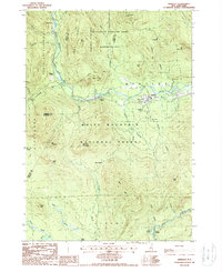
 1988 Umbagog Lake South1988 Print · USGSCrossing the Maine and New Hampshire border in the late eighties, this map captures the wilderness surrounding Umbagog Lake and the village of Upton. Genealogists and researchers can trace local landmarks like Mollidgewock Pond, Black Mountain, and the Dead Cambridge riverway.2 unique versions available
 - 1988 Map of Dummer Ponds
 1988 Dummer Ponds1988 Print · USGSThe high timberlands of Coos County are captured here in the late 1980s, centered on the isolated township of Dummer. Researchers can trace the remote settlement of Paris or locate landmarks like Trio Ponds, Dummer Hill, and the Pontook Res amidst the mountain peaks.2 unique versions available
 - 1988 Map of Stratford
 1988 Stratford1988 Print · USGSThe upper Connecticut River valley comes to life in the late eighties, capturing the border communities of North Stratford and Maidstone in high detail. Genealogists and historians can trace family-named sites like Masons, old transport routes including the Old RR Grade, and remote water bodies like Stratford Bog Pond.
 - 1988 Map of Tinkerville
 1988 Tinkerville1988 Print · USGSThe Upper Connecticut River valley at the New Hampshire-Vermont border reveals its late-twentieth-century rural character here. Researchers can trace the riverfront settlements of Lemington and Tinkerville or locate landmarks like the Columbia Bridge and Wallace Pond.3 unique versions available
 - 1988 Map of Maidstone Lake
 1988 Maidstone Lake1988 Print · USGSThe Northeast Kingdom's transition from timber industry to recreation is visible in this late-century survey of the Connecticut River valley. Trace the legacy of old industrial sites like Browns Mill and the Walker Dam (Site) near Maidstone Lake.
 - 1988 Map of Blue Mountain
 1988 Blue Mountain1988 Print · USGSThe high country of Coos County is revealed in the late eighties, showing a landscape shaped by narrow passes and steep peaks. Researchers can trace the drainage of Simms Stream or locate remote landmarks like Bungy and Cranberry Bog Pond.
 - 1988 Map of West Milan
 1988 West Milan1988 Print · USGSCoos County’s timber and river landscapes are captured here in the late eighties, centered on the Upper Ammonoosuc River valley. Local historians can trace the remote settlements of Crystal and West Milan, alongside landmarks like the Berlin Fish Hatchery and Cedar Pond.
 - 1988 Map of Percy Peaks
 1988 Percy Peaks1988 Print · USGSCoos County's high country is captured here in the late eighties, showing a landscape defined by timber and drainage. Researchers can trace the course of the Upper Ammonoosuc River and find family-named landmarks like Jimmy Cole Ledge and Potters Ledge.2 unique versions available
 - 1988 Map of Stark
 1988 Stark1988 Print · USGSCoos County's mountain wilderness and river-valley settlements are captured here in the late eighties. Genealogists and hikers can trace the geography of isolated places like Lost Nation, the historic Covered Bridge at Stark, and the high reaches of the Pilot Range.2 unique versions available
 - 1988 Map of Dixville Notch
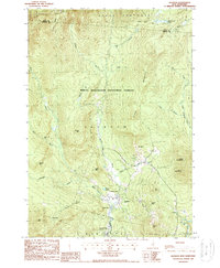
 1988 Dixville Notch1988 Print · USGSThe high mountain passes of Coos County are captured here in the late eighties, just as this wilderness area remained a cornerstone of New Hampshire heritage. Researchers can trace the steep geography of Table Rock, the waters of Lake Gloriette, and the bounds of Dixville Notch State Park.2 unique versions available
Showing maps 1-25 of 46
Top cities of Coos County
- Berlin historical maps
- Lancaster historical maps
- Gorham historical maps
- Whitefield historical maps
- Northumberland historical maps
- Colebrook historical maps
See more
Frequently asked questions
- What are the different types of historical maps available for Coos County?
- What is the oldest map of Coos County?
- Where can I purchase historical maps of Coos County for my home or office?
- Where can I download high-res historical maps of Coos County?
- Are there historical topographic maps available for Coos County?
- Is there historical aerial imagery available for Coos County?
- Where are historical maps of Coos County sourced from?