Old Maps of Coos County, New Hampshire for Metal Detecting
Plan your next treasure hunt with 379 historic maps of Coos County. Find old homesites, ghost towns, trails, and gathering spots that may be lost to time — perfect for identifying promising metal detecting locations.
- Locate forgotten sites: Uncover places like long-lost settlements, abandoned rail lines, or gathering spots.
- Plan better hunts: Use map overlays combined with LiDAR or satellite views to narrow in on historically rich areas.
- Made for detectorists: Thousands of hobbyists use these maps to discover relics, coins, and hidden history.
Use these historic maps to boost your research and find new opportunities beneath the surface of Coos County.
Coos County, NH maps
(379)- 1893 Map of Mt. Washington
 1893 Mt. Washington1893 Print · USGSThe Presidential Range and its grand hotels are captured here during the peak of the late-Victorian mountain tourism era. Trace the path of the Mt. Washington Railway or locate early alpine landmarks like Fabyan House, Halfway House, and the AMC Camp.
 - 1893 Map of Gorham
 1893 Gorham1893 Print · USGSThe northern White Mountains at the height of the 1890s show a landscape shaped by early tourism and the timber industry. Genealogists and hikers can trace historic routes like Madison Path and locate vanished landmarks such as Glen House or the rail yards at Berlin Fall.8 unique versions available
 - 1894 Map of North Conway
 1894 North Conway1894 Print · USGSThe Saco River valley and the eastern White Mountains were at a pivotal moment in the 1890s as rail travel and local industry expanded. Genealogists and hikers can trace old routes near North Conway, the granite works at Redstone, and landmarks like Cathedral Ledge.
 - 1895 Map of Crawford Notch
 1895 Crawford Notch1895 Print · USGSThe White Mountains in the mid-1890s are shown here as a landscape of rail-accessible mountain passes and logging outposts. Genealogists and historians can trace the early tourism hubs of Crawford House and Willey House or the industrial roots of Livermore.
 - 1896 Map of Mt. Washington
 1896 Mt. Washington1896 Print · USGSThe Presidential Range at the height of the Victorian tourism era shows a landscape of grand hotels and pioneering alpine engineering. Trace the historic Mt. Washington Railroad to the summit or locate early hospitality landmarks like the Fabyan House and Ravine House.7 unique versions available
 - 1896 Map of Crawford Notch
 1896 Crawford Notch1896 Print · USGSHigh peaks and early railroad travel define this White Mountain landscape in the 1890s. Genealogists and historians can trace the foundations of Livermore, the Maine Central Railroad route, and landmark hotels like the Crawford House.9 unique versions available
 - 1896 Map of North Conway
 1896 North Conway1896 Print · USGSCarroll County and the surrounding New Hampshire-Maine borderlands are captured here during the peak of the Victorian mountain tourism and rail era. Researchers can trace the dual rail lines serving North Conway and locate long-standing settlements like Jackson, Redstone, and Lower Bartlett.9 unique versions available
 - 1896 Map of Gorham
 1896 Gorham1896 Print · USGSThe White Mountains were a bustling hub of rail activity and early tourism in the 1890s as industry met the wilderness. Genealogists and hikers can trace the original routes of the Grand Trunk Railroad, find the historic Glen House, and locate landmarks like Berlin Falls.
 - 1900 Map of Whitefield
 1900 Whitefield1900 Print · USGSWhite Mountains rail and tourism reached a peak at the turn of the century, as seen in this 1897 survey. Trace the old junctions and grand hotels of the era, from the Mount View House to the busy tracks at Whitefield Junction and Wing Road.5 unique versions available
 - 1920 Map of Guildhall
 1920 Guildhall1920 Print · USGSThe upper Connecticut River valley is captured here in the early twentieth century as a bustling railroad corridor on the border of Vermont and New Hampshire. Genealogists can trace family names at Wheeler Corner or Hapgood Corner and locate regional hubs like North Stratford and Guildhall Station.
 - 1925 Map of Indian Stream
 1925 Indian Stream1925 Print · USGSThe northern tip of New Hampshire is captured here in the mid-1920s, showing a rugged territory of logging camps and border schools. Researchers can trace the lineage of remote settlements through Indian Stream School, Greeleys Camp, and the community at Happy Corner.
 - 1926 Map of Indian Stream
 1926 Indian Stream1926 Print · USGSUpper Coos County at the Canadian border comes alive in this survey of northern New Hampshire's timberlands and early settlements. Genealogists and historians can trace rural schoolhouses like Wheeler School and Indian Stream School, or locate old camps such as Happy Corner and Depot Camp.4 unique versions available
 - 1927 Map of Indian Stream
 1927 Indian Stream1927 Print · USGSThe northern reaches of Coos County are captured here in the mid-1920s, showing the remote borderlands between New Hampshire and Canada. Genealogists and historians can locate rural landmarks like the Clarksville Town Hall, the Wheeler School, and numerous timber camps like Varney Camp.5 unique versions available
 - 1927 Map of Moose Bog
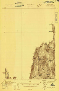 1927 Moose Bog1927 Print · USGSThe wilderness of the North Woods is charted in the late twenties along the border where Maine, New Hampshire, and Quebec meet. Researchers can trace the remote Bowman Farm and the high-elevation wetlands of Moose Bog and the Third East Branch Magalloway River.3 unique versions available
 - 1927 Map of Second Lake, 1955 Print
 1927 Second Lake1955 Print · USGSNorthern New Hampshire's high timberlands and the Connecticut River headwaters appear in the late twenties, spanning from the Canadian border down to the academy grants. Researchers can locate remote logging outposts like Depot Camp and Camp No 32 or trace the early shorelines of Second Lake and First Connecticut Lake.6 unique versions available
 - 1929 Map of Averill
 1929 Averill1929 Print · USGSThe northern borderlands of Vermont and New Hampshire appear here during the peak of the region's timber era. Trace the industrial landscape of the Maine Central RR and early logging outposts like Camp No 10 and Buzzell Dam.5 unique versions available
 - 1930 Map of Milan, 1952 Print
 1930 Milan1952 Print · USGSThe upper Androscoggin River valley is captured here in the early thirties, showing a rugged landscape of timber ridges and river-fed settlements. Genealogists can locate several local schools such as Jewett Sch and the rail-side village of Milan.3 unique versions available
 - 1930 Map of Percy, 1953 Print
 1930 Percy1953 Print · USGSCoos County at the start of the thirties centers on the river valleys and rail lines of the North Country. Genealogists can trace the rural schoolhouses of Blake Sch and Hodgdon Hill Sch or locate family landmarks like Beach Hill and Cummings Mtn.5 unique versions available
 - 1930 Map of Dixville, 1954 Print
 1930 Dixville1954 Print · USGSNorthern New Hampshire at the start of the 1930s reveals a landscape of isolated hill farms and small timber towns. Genealogists can locate family-named landmarks like Piper Hill Cem and numerous district schools including Cedar Brook Sch and Forbes Sch.5 unique versions available
 - 1930 Map of Errol, 1955 Print
 1930 Errol1955 Print · USGSThe timberlands along the New Hampshire and Maine border come alive in the 1930s, centered on the river networks that fueled the region. Genealogists and historians can trace remote outposts like Wilsons Mills, the Magalloway Sch, and industrial markers like Errol Dam.5 unique versions available
 - 1931 Map of Guildhall
 1931 Guildhall1931 Print · USGSThe Upper Connecticut River valley was a bustling rail corridor in the early thirties where New Hampshire and Vermont met. Genealogists and rail historians can trace the paths of the Maine Central RR through Groveton or find rural landmarks like East Stratford Sch.
 - 1931 Map of Littleton
 1931 Littleton1931 Print · USGSUpper Connecticut River Valley life is recorded here in the early thirties, just as aerial photography began to modernize topographic surveying. Genealogists can locate family-named hills and district schools like the Walker Hill Sch and Gilmanton Sch.2 unique versions available
 - 1931 Map of Moose Bog
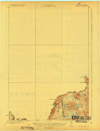 1931 Moose Bog1931 Print · USGSThe Maine and New Hampshire borderlands are captured here in the early thirties, showing a remote wilderness of high peaks and river headwaters. Genealogists and historians can trace family-named landmarks like Bowman Farm, Bowman Hill, and the secluded waters of Moose Bog.5 unique versions available
 - 1932 Map of Second Lake
 1932 Second Lake1932 Print · USGSThe northern New Hampshire wilderness and Maine borderlands are captured here in the early 1930s, showing a landscape of logging camps and high peaks. Genealogists and historians can trace old sites like Idlewild, the Deer Mtn Fire Tower, and remote outposts such as Camp No 36.4 unique versions available
 - 1932 Map of Littleton
 1932 Littleton1932 Print · USGSThe Upper Connecticut River valley and the hills of Vermont's Northeast Kingdom appear here in the early thirties. Trace family connections through numerous rural schoolhouses like Sugar Hill Sch or locate the old Kirby Mtn Quarries and the original path of the Maine Central Railroad.3 unique versions available
Showing maps 1-25 of 379
Top cities of Coos County
- Berlin historical maps
- Lancaster historical maps
- Gorham historical maps
- Whitefield historical maps
- Northumberland historical maps
- Colebrook historical maps
See more
Frequently asked questions
- What are the different types of historical maps available for Coos County?
- What is the oldest map of Coos County?
- Where can I purchase historical maps of Coos County for my home or office?
- Where can I download high-res historical maps of Coos County?
- Are there historical topographic maps available for Coos County?
- Is there historical aerial imagery available for Coos County?
- Where are historical maps of Coos County sourced from?