1950s Maps of Coos County, New Hampshire
Explore 5 historic maps of Coos County from the 1950s. These maps offer a rare glimpse into what life looked like during the 1950s — showing old roads, neighborhoods, homes, and landmarks that have changed or disappeared over time.
Whether you're researching your family's past, planning a metal detecting trip, or studying how Coos County's landscape evolved across the 1950s, these high-resolution maps are a powerful tool for exploring the history of this region.
- Focus on a specific era: All maps on this page are from the 1950s, giving you a focused view of this time period.
- See what’s changed: Compare century-old streets, trails, and buildings to today's modern landscape using overlays and satellite layers.
- Research with precision: Use these maps for genealogy, historical research, land use analysis, or educational projects.
- View, download, or print: Maps are fully viewable online in high resolution, and can be downloaded or printed for your own records.
Start exploring Coos County's history through authentic maps from the 1950s. This is your window into the past.
Coos County, NH maps
(5)- 1950 Map of Crawford Notch
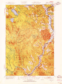
 1950 Crawford Notch1950 Print · USGSGrafton and Carroll Counties are shown here during the mid-century peak of White Mountain hiking and rail travel. Researchers can trace historic trails like the Davis Path, find old mountain outposts like Willey House PO, or locate the logging settlement of Livermore.3 unique versions available
 - 1950 Map of Lewiston
 1950 Lewiston1950 Print · USGSThe Maine and New Hampshire borderlands come alive in this post-war survey of the White Mountains and Androscoggin valley. Genealogists and historians can trace rail lines like the Maine Central Railroad and find high-altitude landmarks from Mount Washington to Bretton Woods.2 unique versions available
 - 1953 Map of Averill, 1954 Print
 1953 Averill1954 Print · USGSThe northern edge of Vermont and New Hampshire meets the Quebec border in this mid-century portrait of a river-and-rail economy. Researchers can trace family sites from the Alice Hunt Cemetery to the crossing at Columbia Bridge and the logging camps of Lemington.5 unique versions available
 - 1956 Map of Guildhall, 1957 Print
 1956 Guildhall1957 Print · USGSThe upper Connecticut River valley comes alive in the mid-fifties, showing the rail-and-river economy of the Vermont-New Hampshire border. Genealogists and researchers can trace the tracks of the Grand Trunk railroad through North Stratford or locate the Central Sch and Browns Mill.3 unique versions available
 - 1956 Map of Lewiston, 1975 Print
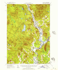
 1956 Lewiston1975 Print · USGSThe Northern New England interior is documented here in the mid-fifties, from the industrial Androscoggin River to the high peaks of the White Mountains. Trace the Grand Trunk Railway through mountain passes or locate family landmarks near Sabbathday Lake and Bretton Woods.
End of results
Showing maps 1-5 of 5
Top cities of Coos County
- Berlin historical maps
- Lancaster historical maps
- Gorham historical maps
- Whitefield historical maps
- Northumberland historical maps
- Colebrook historical maps
See more
Frequently asked questions
- What are the different types of historical maps available for Coos County?
- What is the oldest map of Coos County?
- Where can I purchase historical maps of Coos County for my home or office?
- Where can I download high-res historical maps of Coos County?
- Are there historical topographic maps available for Coos County?
- Is there historical aerial imagery available for Coos County?
- Where are historical maps of Coos County sourced from?