1990s Maps of Coos County, New Hampshire
Explore 28 historic maps of Coos County from the 1990s. These maps offer a rare glimpse into what life looked like during the 1990s — showing old roads, neighborhoods, homes, and landmarks that have changed or disappeared over time.
Whether you're researching your family's past, planning a metal detecting trip, or studying how Coos County's landscape evolved across the 1990s, these high-resolution maps are a powerful tool for exploring the history of this region.
- Focus on a specific era: All maps on this page are from the 1990s, giving you a focused view of this time period.
- See what’s changed: Compare century-old streets, trails, and buildings to today's modern landscape using overlays and satellite layers.
- Research with precision: Use these maps for genealogy, historical research, land use analysis, or educational projects.
- View, download, or print: Maps are fully viewable online in high resolution, and can be downloaded or printed for your own records.
Start exploring Coos County's history through authentic maps from the 1990s. This is your window into the past.
Coos County, NH maps
(28)- 1995 Map of Errol
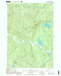 1995 Errol1995 Print · USGSNorthwoods life in Coos County during the 1990s centers on the village of Errol and the wild river corridors of the Androscoggin River. Trace the boundaries of historic land grants or locate remote landmarks like Ellingwood Falls and Signal Mountain.2 unique versions available
 - 1995 Map of Mount Washington, 1999 Print
 1995 Mount Washington1999 Print · USGSThe Presidential Range in the mid-1990s is captured here in detail, showcasing the iconic Cog Railroad and the high-alpine terrain of the Great Gulf Wilderness. Researchers can trace historic hiking routes like the Appalachian Trail and locate remote landmarks such as Lakes of the Clouds Hut and Madison Hut.
 - 1995 Map of Umbagog Lake South, 1999 Print
 1995 Umbagog Lake South1999 Print · USGSThe rugged New Hampshire-Maine borderlands are captured here in the mid-1990s as a haven for forestry and conservation. You can trace the wilderness roads through Upton and locate remote landmarks like Metallak Island or the Cem near the Maine state line.
 - 1995 Map of Mount Crescent, 1999 Print
 1995 Mount Crescent1999 Print · USGSThe White Mountains in the mid-1990s showcase a high-elevation landscape of state hatcheries and historic hill settlements. Researchers can trace local landmarks like the Randolph Church, the remote Pond of Safety, and the dramatic terrain of Ice Gulch.
 - 1995 Map of Stairs Mountain, 2000 Print
 1995 Stairs Mountain2000 Print · USGSThe White Mountains in the mid-nineties show a landscape of steep peaks and historic land grants. Hikers and historians can trace the paths of Sargents Purchase and locate high-altitude landmarks like Mizpah Spring Hut and Willey House PO.
 - 1995 Map of Jackson, 2000 Print
 1995 Jackson2000 Print · USGSJackson and the surrounding White Mountains are captured here in the mid-nineties, showing the village just as the Wildcat Brook was designated a Wild and Scenic River. Hikers and historians can trace the Appalachian Trail, locate the historic Covered Bridge, and find remote landmarks like Doublehead Cabin and Perkins Notch Shelter.
 - 1995 Map of Mount Dartmouth, 2000 Print
 1995 Mount Dartmouth2000 Print · USGSThe high peaks and resort valleys of the White Mountains are shown here in the mid-1990s as the regional landscape balanced tourism and conservation. Researchers can trace historic land grants and local landmarks like Bretton Woods, Fabyan, and Mount Dartmouth.
 - 1995 Map of Bartlett, 2000 Print
 1995 Bartlett2000 Print · USGSThe Saco River valley and its mountain peaks are documented here in the mid-1990s as a hub of forestry and recreation. Researchers can trace the layout of Bartlett, locate the Cem, and follow early access routes like Notch Road and the Parker Trail.
 - 1995 Map of West Milan, 2000 Print
 1995 West Milan2000 Print · USGSCoos County, New Hampshire, is captured here in the mid-1990s as a landscape of managed forests and river valley settlements. Genealogists and local historians can trace the areas around West Milan and Crystal, or locate the Berlin Fish Hatchery and numerous landmarks like Rogers Ledge.
 - 1995 Map of Stark, 2000 Print
 1995 Stark2000 Print · USGSCoos County in the mid-nineties shows the isolated settlements and forest boundaries of the northern peaks just before the turn of the millennium. Genealogists and hikers can trace the Ammonoosuc River to find the Stark Covered Bridge, local Cem sites, and the remote Lost Nation.
 - 1995 Map of Carter Dome, 2000 Print
 1995 Carter Dome2000 Print · USGSThe high peaks and forest grants of the White Mountains are shown here in the mid-nineties, capturing a landscape of alpine recreation and timber-era boundaries. Researchers can trace the Appalachian National Scenic Trail past the Carter Notch Hut and locate historical landmarks like Glen House.
 - 1995 Map of Twin Mountain, 2000 Print
 1995 Twin Mountain2000 Print · USGSIn the mid-1990s, the rural landscapes of Coos County were shaped by the historic MAINE CENTRAL railroad and the AMMONOOSUC RIVER. Genealogists and researchers can trace the roads to Carroll Cemetery, the Twin Mountain Fish Hatchery, and the rail nexus at Quebec Junction.
 - 1995 Map of Bethlehem, 2000 Print
 1995 Bethlehem2000 Print · USGSThe Ammonoosuc River valley in the mid-nineties shows a landscape of mountain forests and historic resort-era settlements. Researchers can locate family plots at Maple Street Cemetery and trace the path of the Boston and Maine rail line through Wing Road and Pierce Bridge.
 - 1995 Map of Wild River, 2000 Print
 1995 Wild River2000 Print · USGSThe White Mountains come alive in the 1990s as this map traces the intricate trail networks and wilderness reaches across the New Hampshire and Maine state line. Researchers can locate remote landmarks like the Brickett Place or trace the Appalachian Trail as it passes Middle Moriah Mountain.
 - 1995 Map of Crawford Notch, 2000 Print
 1995 Crawford Notch2000 Print · USGSGrafton and Carroll Counties are shown here during the mid-nineties, capturing the extensive trail systems and wilderness boundaries of the White Mountains. Hikers and historians can trace the Appalachian National Scenic Trail past Zealand Falls or locate the historic Willey House (Site).
 - 1995 Map of Umbagog Lake North, 2000 Print
 1995 Umbagog Lake North2000 Print · USGSThe northern reaches of the New Hampshire and Maine border are preserved here in the mid-nineties, showing a landscape defined by timber grants and vast water networks. Researchers can trace the early footprints of Wentworth Location and Errol or locate family-named features like Sturtevant Mountain and Mt Dustan.
 - 1995 Map of Jefferson, 2000 Print
 1995 Jefferson2000 Print · USGSThe northern reaches of the White Mountains are captured here in the mid-nineties, showing the valley communities of Jefferson and Jefferson Highland tucked against the high peaks. Genealogists and hikers can trace local roots at Forest Vale Cemetery or follow historic paths through Bunnell Notch.
 - 1995 Map of Chatham, 2000 Print
 1995 Chatham2000 Print · USGSChatham and the White Mountain high country are captured here in the mid-1990s as a haven for hikers and remote settlers. Researchers can trace the trails and summits of Sable Mountain or locate the Cold River AMC Camp and local cemeteries.
 - 1995 Map of Shelburne, 2001 Print
 1995 Shelburne2001 Print · USGSThe northern New Hampshire border and the Wild River territory come alive in the mid-1990s as the Androscoggin River valley meets the high peaks. Hikers and historians can trace the Appalachian Scenic Trail past Gentian Pond and locate the historic Hazelton Cem near Shelburne.
 - 1995 Map of Berlin, 2001 Print
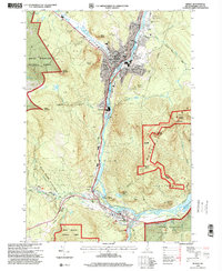 1995 Berlin2001 Print · USGSThe industrial corridor of the North Country comes into sharp focus during the 1990s as the Androscoggin River winds through the mill towns. Genealogists and local historians can trace the foundations of these communities through landmarks like Notre Dame High Sch, City Cemetery, and the St Lawrence and Atlantic RR.
 - 1996 Map of Lovering Mountain, 2000 Print
 1996 Lovering Mountain2000 Print · USGSNorthern Coos County is shown in the mid-1990s as the regional landscape supported both forest management and recreation. Researchers can trace the layout of Colebrook, find the Fish Hatchery, and locate local landmarks such as Stewartstown Hollow or Beaver Brook Falls.
 - 1996 Map of Diamond Pond, 2000 Print
 1996 Diamond Pond2000 Print · USGSCoos County at the close of the twentieth century shows a landscape of mountain ridges and remote forest camps. Genealogists and outdoor historians can trace the paths between Kidderville, the recreational reaches of Coleman State Park, and family landmarks like Ramsay Camp.
 - 1996 Map of Blue Mountain, 2000 Print
 1996 Blue Mountain2000 Print · USGSCoos County's high-country peaks and protected timberlands are documented in detail during the mid-1990s. Researchers can locate the small settlement of Bungy, trace the drainage of Simms Stream, and find family history markers like the Cemetery near Carlton Hill.
 - 1996 Map of Dummer Ponds, 2000 Print
 1996 Dummer Ponds2000 Print · USGSCoos County at the close of the twentieth century reveals a landscape defined by state forests and high-elevation water bodies. Genealogists and historians can trace the settlement of Paris and locate family-named landmarks like Dummer Hill or Bickford Hill.
 - 1996 Map of Dixville Notch, 2000 Print
 1996 Dixville Notch2000 Print · USGSNorthern New Hampshire's high mountain passes and vast timberlands are documented in the mid-1990s. Researchers can locate remote landmarks like the Grave near Dixville Notch, and trace the waterways of Millsfield Pond, Lake Gloriette, and Phillips Pond.
Showing maps 1-25 of 28
Top cities of Coos County
- Berlin historical maps
- Lancaster historical maps
- Gorham historical maps
- Whitefield historical maps
- Northumberland historical maps
- Colebrook historical maps
See more
Frequently asked questions
- What are the different types of historical maps available for Coos County?
- What is the oldest map of Coos County?
- Where can I purchase historical maps of Coos County for my home or office?
- Where can I download high-res historical maps of Coos County?
- Are there historical topographic maps available for Coos County?
- Is there historical aerial imagery available for Coos County?
- Where are historical maps of Coos County sourced from?