1970s Maps of Harding County, New Mexico
Explore 30 historic maps of Harding County from the 1970s. These maps offer a rare glimpse into what life looked like during the 1970s — showing old roads, neighborhoods, homes, and landmarks that have changed or disappeared over time.
Whether you're researching your family's past, planning a metal detecting trip, or studying how Harding County's landscape evolved across the 1970s, these high-resolution maps are a powerful tool for exploring the history of this region.
- Focus on a specific era: All maps on this page are from the 1970s, giving you a focused view of this time period.
- See what’s changed: Compare century-old streets, trails, and buildings to today's modern landscape using overlays and satellite layers.
- Research with precision: Use these maps for genealogy, historical research, land use analysis, or educational projects.
- View, download, or print: Maps are fully viewable online in high resolution, and can be downloaded or printed for your own records.
Start exploring Harding County's history through authentic maps from the 1970s. This is your window into the past.
Harding County, NM maps
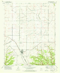
(30)- 1971 Map of Abbott Lake, 1973 Print
 1971 Abbott Lake1973 Print · USGSHarding and Colfax Counties are shown in the early seventies, capturing a landscape of high plains ranching and former rail corridors. Researchers can trace the Old Railroad Grade and locate family history at Johnson Cem near Abbott Lake.
 - 1971 Map of Beaver Canyon, 1975 Print
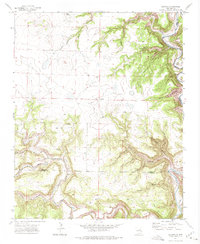
 1971 Beaver Canyon1975 Print · USGSThe Canadian River breaks across the high plains of Harding and Mora counties in the early 1970s. Trace old Jeep Trails and remote landmarks like the Cem and Upper Horseshoe Bend as they appeared before modern development.
 - 1971 Map of Alamito, 1975 Print
 1971 Alamito1975 Print · USGSNortheastern New Mexico ranchlands meet the deep river breaks of the High Plains in the early seventies. Genealogists and local historians can trace family-named landmarks like Cañon de los Nieves and Banco Redondo near the remote settlement of Alamito.
 - 1971 Map of Canon Las Cuevas, 1975 Print
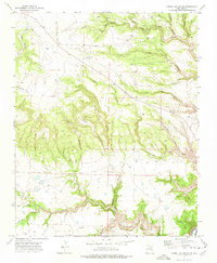 1971 Canon Las Cuevas1975 Print · USGSMora County ranching country is documented here in the early seventies, showcasing a landscape of deep canyons and high mesas. Genealogists and historians can locate isolated landmarks like the Thompson Windmill, a solitary Grave, and the winding Mills Canyon Road.
 - 1971 Map of Canon Encierro, 1975 Print
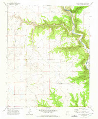
 1971 Canon Encierro1975 Print · USGSThe high canyon country of northeastern New Mexico is captured here in the early seventies, showing a landscape defined by the winding Canadian River. Researchers can locate isolated burial sites like Armenta Plaza Cem and trace old family landforms such as Valle Romero.
 - 1972 Map of Canon Colorado, 1975 Print
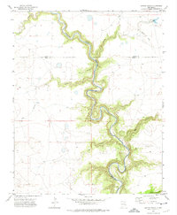
 1972 Canon Colorado1975 Print · USGSThe high plains of Mora County meet the deep canyons of the Canadian River in the early 1970s. Researchers can locate the Paises Cem and trace the remote routes of Mills Canyon Road near the Adobe and Monett settlements.
 - 1972 Map of Jaritas Ranch, 1975 Print
 1972 Jaritas Ranch1975 Print · USGSRanching life in northeastern New Mexico during the early seventies centers on the deep canyons of the Canadian River. Genealogists and historians can trace the Old Railroad Grade and remote landmarks like Jaritas Ranch and Dog Canyon.
 - 1972 Map of Mills West, 1975 Print
 1972 Mills West1975 Print · USGSHarding County ranchlands and the deep breaks of the Canadian River define this area during the early seventies. Genealogists and local historians can trace the Old Railroad Grade past Mills or locate the remote Mesteñito Cem.
 - 1973 Map of Bueyeros NE, 1977 Print
 1973 Bueyeros NE1977 Print · USGSHarding County ranching country is captured here in the early 1970s, showcasing a landscape of high escarpments and remote outposts. Researchers can locate the Culberthson Ranch, a local Cem, and the striking Cejita De Los Comancheros.
 - 1973 Map of Circle Bar Ranch, 1977 Print
 1973 Circle Bar Ranch1977 Print · USGSHarding County ranching country is documented here in the early seventies, showing a landscape of high-plains cattle operations and vital water points. Genealogists and historians can trace rangeland landmarks like the Circle Bar Ranch, Grandma Mitchell Windmill, and the Penitente Windmill.
 - 1973 Map of Indian Bathtub, 1977 Print
 1973 Indian Bathtub1977 Print · USGSHarding County ranching land in the early 1970s was a network of family wells and remote water holes. Genealogists and local historians can trace legacy sites like Cejita Cem, Lopez Well No 1, and the unique Indian Bathtub.
 - 1973 Map of Yates SE, 1977 Print
 1973 Yates SE1977 Print · USGSThe high plains of Harding and Union counties are shown in the early seventies, a landscape of ranching and energy. Researchers can locate the small settlement of Clavels, several Falls along Alamocita Creek, and an isolated rural Cem.
 - 1973 Map of Mosquero, 1977 Print
 1973 Mosquero1977 Print · USGSThe village of Mosquero sits at the junction of the high plains and canyon country in the early seventies. Genealogists and local historians can trace legacy land markers like the Pablo Montoya grant, Mosquero Cem, and the settlement at Daniel.
 - 1973 Map of Sabino, 1978 Print
 1973 Sabino1978 Print · USGSHarding County, New Mexico, is shown here in the early 1970s as a landscape of deep canyons and isolated high-plains settlements. Genealogists and historians can trace the foundations of local life through rural sites like Old Sabino Camp, Trujillo Cem, and Garcia Cem.
 - 1973 Map of Minnie Butte, 1978 Print
 1973 Minnie Butte1978 Print · USGSNortheast New Mexico ranching country remains captured here in the early seventies, spanning the border of Union and Harding counties. Genealogists and local historians can trace the Miera Ch Cem, find the Miera settlement, and locate rural landmarks like Jeffrey and Minnie Butte.
 - 1973 Map of Bueyeros, 1978 Print
 1973 Bueyeros1978 Print · USGSNortheastern New Mexico's high plains meet the breaks of the Ute Creek valley in the 1970s. Researchers can locate the small community of Bueyeros, a local Cemetery, and specialized Carbon Dioxide Gas Wells set against the backdrop of Mesa Quitaras.
 - 1973 Map of Albert, 1978 Print
 1973 Albert1978 Print · USGSHarding County ranching and early carbon dioxide exploration are captured here in the early seventies. Trace local family history through the Albert Academy, rural Cem sites, and the small settlement at Albert PO.
 - 1973 Map of Arroyo Del Alamo, 1978 Print
 1973 Arroyo Del Alamo1978 Print · USGSHarding County in the early seventies reveals a landscape of isolated ranch camps and emerging energy exploration. Family historians and researchers can trace the location of David Cem, Bar T Cross Camp, and many reliable water sources like Tejano Spring.
 - 1973 Map of Valencia Spring, 1978 Print
 1973 Valencia Spring1978 Print · USGSHarding County ranching country is documented here in the early 1970s as the landscape adapted to modern transport while remaining tied to its vital springs. Researchers can trace remote sites like Carrizo Camp, find the Carrizo Cemetery, and locate water sources like Valencia Spring.
 - 1974 Map of Roy, 1977 Print
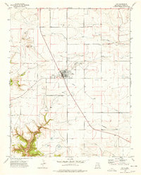 1974 Roy1977 Print · USGSHarding County life in the mid-seventies centers on the high plains town of Roy, where the community's agricultural and social infrastructure is clearly mapped. Genealogists and historians can trace local landmarks like the Cem, County Fairground, and the canyons of La Cinta Canyon to the south.
 - 1974 Map of Kansas Valley, 1977 Print
 1974 Kansas Valley1977 Print · USGSThe open ranchlands of Harding County appear in detail here during the mid-1970s. Researchers can trace the essential water infrastructure of the high plains through family-named landmarks like Jackson Windmill, Slusher Windmill, and the drainage of Carrizo Creek.
 - 1974 Map of Kansas Valley Lake, 1978 Print
 1974 Kansas Valley Lake1978 Print · USGSHarding County ranching country is captured here in the mid-1970s, showing a landscape defined by water management and isolated landmarks. Researchers can trace family-named features like Johnson Cem, Weisdorfer Draw, and the curiously named Starvation Windmill.
 - 1974 Map of Mills East, 1978 Print
 1974 Mills East1978 Print · USGSHarding County ranching and rail history come alive in this mid-seventies survey of the high plains. Researchers can trace family-named landmarks and infrastructure like the Mills Cem, the Old RR Grade, and the Rigoni Landing Strips.
 - 1974 Map of Spear Hills, 1978 Print
 1974 Spear Hills1978 Print · USGSThe ranching country of the New Mexico high plains comes into focus in the mid-1970s, as fences and wells define the landscape. Researchers can trace rural settlement patterns through family-named landmarks like Franks Place Well, Searite Well, and the small community at Edna.
 - 1974 Map of Divine Lake, 1978 Print
 1974 Divine Lake1978 Print · USGSNortheastern New Mexico's high ranching country is documented here in the mid-1970s at the meeting of three counties. Local history researchers can locate family-named landmarks like Sugarloaf Ranch and Mofax Cem, or trace water sources from Carrizo Creek to Gaines Well.
Showing maps 1-25 of 30
Top cities of Harding County
Frequently asked questions
- What are the different types of historical maps available for Harding County?
- What is the oldest map of Harding County?
- Where can I purchase historical maps of Harding County for my home or office?
- Where can I download high-res historical maps of Harding County?
- Are there historical topographic maps available for Harding County?
- Is there historical aerial imagery available for Harding County?
- Where are historical maps of Harding County sourced from?