1940s Maps of Luna County, New Mexico
Explore 4 historic maps of Luna County from the 1940s. These maps offer a rare glimpse into what life looked like during the 1940s — showing old roads, neighborhoods, homes, and landmarks that have changed or disappeared over time.
Whether you're researching your family's past, planning a metal detecting trip, or studying how Luna County's landscape evolved across the 1940s, these high-resolution maps are a powerful tool for exploring the history of this region.
- Focus on a specific era: All maps on this page are from the 1940s, giving you a focused view of this time period.
- See what’s changed: Compare century-old streets, trails, and buildings to today's modern landscape using overlays and satellite layers.
- Research with precision: Use these maps for genealogy, historical research, land use analysis, or educational projects.
- View, download, or print: Maps are fully viewable online in high resolution, and can be downloaded or printed for your own records.
Start exploring Luna County's history through authentic maps from the 1940s. This is your window into the past.
Luna County, NM maps
(4)- 1943 Map of Hermanas
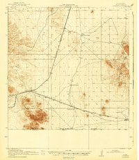 1943 Hermanas1943 Print · USGSThe high desert of Luna County is seen here during the mid-century, anchored by the border crossing and railroad at Hermanas. Genealogists and historians can locate early family outposts like Dogtown Ranch, White House Ranch, and Cox Ranch.
 - 1947 Map of Faywood Station, 1966 Print
 1947 Faywood Station1966 Print · USGSHigh desert ranching and rail infrastructure dominate the landscape of Grant and Luna counties in the late 1940s. Trace the diagonal path of the Atchison Topeka and Santa Fe past Faywood Station and the oasis at Warm Springs.2 unique versions available
 - 1949 Map of Whitewater
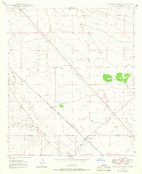
 1949 Whitewater1949 Print · USGSSouthwest New Mexico's high desert reveals its mid-century rail and ranching character just after the war. You can trace the transition between the active Atchison Topeka and Santa Fe and its abandoned grade near Whitewater and Hogback Mountain.2 unique versions available
 - 1949 Map of Faywood Station
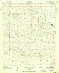
 1949 Faywood Station1949 Print · USGSThe high desert of New Mexico comes into focus during the late 1940s as a landscape of railroads and vital water sources. Trace the path of the Atchison Topeka and Santa Fe to the lonely outpost at Faywood Station and the oasis at Warm Springs.
End of results
Showing maps 1-4 of 4
Top cities of Luna County
Frequently asked questions
- What are the different types of historical maps available for Luna County?
- What is the oldest map of Luna County?
- Where can I purchase historical maps of Luna County for my home or office?
- Where can I download high-res historical maps of Luna County?
- Are there historical topographic maps available for Luna County?
- Is there historical aerial imagery available for Luna County?
- Where are historical maps of Luna County sourced from?