Old Maps of Luna County, New Mexico for Genealogy
Trace your family roots with 387 historic maps of Luna County. These high-res maps reveal old neighborhoods, homesites, landmarks, and streets — helping you uncover where your ancestors lived and how the area evolved over time.
- Explore historic neighborhoods: Identify where your relatives may have lived in the 1800s or 1900s.
- Compare maps over time: Trace the changes in streets, buildings, and landmarks for multi-generational research.
- Perfect for genealogy & ancestry research: Used by family historians and researchers to map out lineage and migration.
These maps are an incredible resource for exploring your personal connection to Luna County's past.
Luna County, NM maps
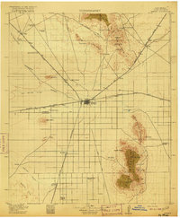
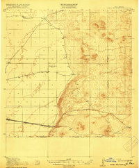
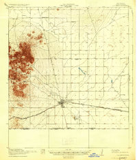
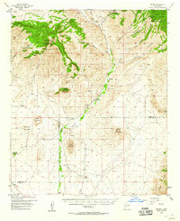
(387)- 1899 Map of Deming
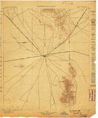 1899 Deming1899 Print · USGSRailroads converge at the desert hub of Deming before the turn of the century, revealing a landscape of frontier outposts and isolated water tanks. Genealogists and historians can trace rail-side stops like Tunis and Florida or the site of historic Fort Cummings.2 unique versions available
 - 1909 Map of Silver City
 1909 Silver City1909 Print · USGSSilver City and the surrounding mining districts are shown at their industrial peak before the First World War. Researchers can trace early railroad spurs to camps like Santa Rita and Fierro, or locate the expansive Fort Bayard Military Reservation.2 unique versions available
 - 1915 Map of Deming
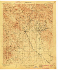
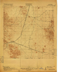
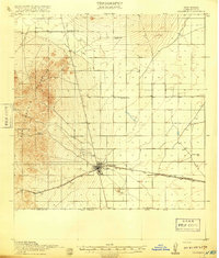
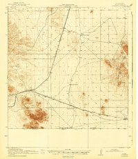
 1915 Deming1915 Print · USGSDeming and the surrounding high desert of Luna County were a critical crossroads of Southwestern rail and wagon traffic at the start of the twentieth century. Genealogists can locate family holdings like the 76 Ranch and early social hubs including Midway Iola P O and Tunis School.4 unique versions available
 - 1917 Map of Hermanas
 1917 Hermanas1917 Print · USGSSouthern New Mexico was a critical frontier at the time of the Great War, defined by cattle ranching and international border security. Researchers can trace the path of the El Paso and Southwestern Road and locate remote outposts like Dogtown Ranch, Mahoney, and Hermanas.
 - 1917 Map of Camel Mountain
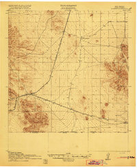
 1917 Camel Mountain1917 Print · USGSThe high desert along the New Mexico-Mexico border comes into focus during the early twentieth century. Genealogists and historians can trace isolated homesteads such as Engle and Minor Ranch and the railroad siding at Arena along the El Paso and Southwestern line.2 unique versions available
 - 1917 Map of Columbus, 1920 Print
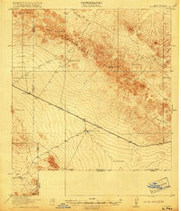
 1917 Columbus1920 Print · USGSThe high desert of southern Luna County comes alive in this late-1910s survey of the international border region near Columbus. Researchers can trace the rail corridor of the El Paso and Southwestern and locate remote landmarks like Stephenson Ranch and the Boundary Gate.3 unique versions available
 - 1918 Map of Columbus
 1918 Columbus1918 Print · USGSThe New Mexico borderlands come alive in this survey of the high desert during a period of intense military and rail activity. Genealogists and historians can trace family outposts from Stephenson Ranch to Waterloo, while following the El Paso and Southwestern rail line as it nears the United States Mexico Boundary Line.2 unique versions available
 - 1918 Map of Hermanas
 1918 Hermanas1918 Print · USGSThis Luna County borderland is shown just as the ranching and railroad era reached its height along the Mexican border. Genealogists and historians can trace the early cattle operations of Dogtown Ranch and Hoppy Ranch or follow the tracks of the El Paso and Southwestern Road.
 - 1918 Map of Victorio
 1918 Victorio1918 Print · USGSThe New Mexico borderlands during the Great War era reveal a landscape of isolated ranching outposts and international mining operations. Researchers can locate family landmarks like Bud Williams Ranch and trace the historic El Paso and Southwestern rail line.3 unique versions available
 - 1920 Map of Columbus, 1931 Print
 1920 Columbus1931 Print · USGSThe New Mexico borderlands come into focus in the years following the border raids, centered on the strategic railroad town of Columbus. Family historians can trace early ranching life at Stephenson Ranch or locate vanished rural outposts like Waterloo and Mayfield School.3 unique versions available
 - 1943 Map of Hermanas
 1943 Hermanas1943 Print · USGSThe high desert of Luna County is seen here during the mid-century, anchored by the border crossing and railroad at Hermanas. Genealogists and historians can locate early family outposts like Dogtown Ranch, White House Ranch, and Cox Ranch.
 - 1947 Map of Faywood Station, 1966 Print
 1947 Faywood Station1966 Print · USGSHigh desert ranching and rail infrastructure dominate the landscape of Grant and Luna counties in the late 1940s. Trace the diagonal path of the Atchison Topeka and Santa Fe past Faywood Station and the oasis at Warm Springs.2 unique versions available
 - 1949 Map of Whitewater
 1949 Whitewater1949 Print · USGSSouthwest New Mexico's high desert reveals its mid-century rail and ranching character just after the war. You can trace the transition between the active Atchison Topeka and Santa Fe and its abandoned grade near Whitewater and Hogback Mountain.2 unique versions available
 - 1949 Map of Faywood Station
 1949 Faywood Station1949 Print · USGSThe high desert of New Mexico comes into focus during the late 1940s as a landscape of railroads and vital water sources. Trace the path of the Atchison Topeka and Santa Fe to the lonely outpost at Faywood Station and the oasis at Warm Springs.
 - 1953 Map of El Paso
 1953 El Paso1953 Print · USGSEl Paso and the border region are shown here in the early fifties, documenting a landscape of shared river life and rising military presence. Genealogists and historians can trace rail-tied communities like Smeltertown, San Elizario, and the grounds of Fort Bliss.
 - 1954 Map of Silver City, 1967 Print
 1954 Silver City1967 Print · USGSSoutheast Arizona and southwest New Mexico meet in this mid-century survey of the high desert and mountain mining districts. Local researchers can trace the rail lines through Lordsburg, the silver operations at Ash Peak Mines, and the limits of Fort Bayard Military Reservation.4 unique versions available
 - 1955 Map of Douglas
 1955 Douglas1955 Print · USGSThe Arizona and New Mexico borderlands come into focus in the mid-1950s, highlighting the mining and ranching hubs of the Desert Southwest. Genealogists and historians can trace the foundations of Bisbee, the operations at Hachita Mine, and rural landmarks like the Double Adobe School.2 unique versions available
 - 1955 Map of Las Cruces, 1963 Print
 1955 Las Cruces1963 Print · USGSSouthern New Mexico comes into focus during the mid-fifties, showing the growth of Las Cruces alongside major military and scientific installations. Genealogists and historians can trace the Southern Pacific tracks through small rail towns like Cambray and Afton, or locate family sites near Hatch and Deming.3 unique versions available
 - 1956 Map of Dwyer, 1958 Print
 1956 Dwyer1958 Print · USGSThe Mimbres River valley was a vital corridor of ranching and early mining in the 1950s. Genealogists and historians can trace family roots through the Dwyer (Faywood PO) settlement, San Jose Ch, and the high-country Big Mill.2 unique versions available
 - 1958 Map of Las Cruces
 1958 Las Cruces1958 Print · USGSSouthern New Mexico in the late fifties was a landscape of rapid scientific and military growth centered on the Rio Grande. Local historians can trace the development of Las Cruces, the campus of New Mexico A and M College, and remote rail sidings like Aden Siding.
 - 1958 Map of Silver City
 1958 Silver City1958 Print · USGSSouthwestern New Mexico and eastern Arizona appear here in the mid-1950s, a period of intensive mining and rail activity. Trace the routes of the Southern Pacific RR through Lordsburg or locate historic operations at the Chino Mine and Santa Rita.
 - 1959 Map of Douglas, 1968 Print
 1959 Douglas1968 Print · USGSSoutheast Arizona and southwest New Mexico meet at the border in the late fifties, showcasing a high-desert landscape defined by industrial copper mining and ranching. Genealogists and historians can trace the foundations of Bisbee, locate the Lavender Pit, and follow the Southern Pacific line through Douglas.4 unique versions available
 - 1959 Map of El Paso, 1968 Print
 1959 El Paso1968 Print · USGSEl Paso and the international borderlands come alive in this mid-century survey of the Chihuahuan Desert. Genealogists and historians can trace rail-side settlements like Columbus and Fabens, locate the sprawling Fort Bliss, and explore the geologically unique Kilbourne Hole.2 unique versions available
 - 1961 Map of Douglas
 1961 Douglas1961 Print · USGSThe Arizona-Mexico borderlands come into focus at mid-century, detailing the vital mining and ranching hubs of Cochise County and southwest New Mexico. Genealogists and historians can trace the Southern Pacific Railroad through Bisbee and Douglas, or locate early sites like the Old Hachita Mine and Rucker School.
 - 1961 Map of Nutt, 1964 Print
 1961 Nutt1964 Print · USGSThe high desert at the meeting of Sierra, Dona Ana, and Luna counties is captured here in the early sixties as the rail-and-ranch economy shaped the landscape. Trace family history at North Cem or Duncan Ranch, and follow the old Atchison Topeka and Santa Fe line past Nutt.2 unique versions available
Showing maps 1-25 of 387
Top cities of Luna County
Frequently asked questions
- What are the different types of historical maps available for Luna County?
- What is the oldest map of Luna County?
- Where can I purchase historical maps of Luna County for my home or office?
- Where can I download high-res historical maps of Luna County?
- Are there historical topographic maps available for Luna County?
- Is there historical aerial imagery available for Luna County?
- Where are historical maps of Luna County sourced from?